1980s Maps of Shaniko, Oregon
Explore 4 historic maps of Shaniko from the 1980s. These maps offer a rare glimpse into what life looked like during the 1980s — showing old roads, neighborhoods, homes, and landmarks that have changed or disappeared over time.
Whether you're researching your family's past, planning a metal detecting trip, or studying how Shaniko's landscape evolved across the 1980s, these high-resolution maps are a powerful tool for exploring the history of this region.
- Focus on a specific era: All maps on this page are from the 1980s, giving you a focused view of this time period.
- See what’s changed: Compare century-old streets, trails, and buildings to today's modern landscape using overlays and satellite layers.
- Research with precision: Use these maps for genealogy, historical research, land use analysis, or educational projects.
- View, download, or print: Maps are fully viewable online in high resolution, and can be downloaded or printed for your own records.
Start exploring Shaniko's history through authentic maps from the 1980s. This is your window into the past.
Shaniko, OR maps
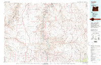
(4)- 1981 Map of Stephenson Mountain, 1997 Print
 1981 Stephenson Mountain1997 Print · USGSThe high-desert ranching and mining heart of North Central Oregon is captured here in the early eighties. Genealogists and historians can trace old settlements and mineral prospects from Shaniko to the Oregon King Mine and the John Day River canyon.
 - 1981 Map of Condon, 1997 Print
 1981 Condon1997 Print · USGSNorth-central Oregon in the early eighties reveals a vast plateau landscape defined by the deep canyons of the John Day and Deschutes rivers. Researchers can trace the rural legacy of the region through small hubs like Condon, Fossil, and the Old Railroad Grade.2 unique versions available
 - 1987 Map of Antelope, 1988 Print
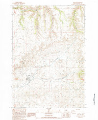 1987 Antelope1988 Print · USGSAntelope is shown during the late 1980s, situated at the meeting point of high-desert canyons and vital watercourses. Genealogists and local historians can trace the town layout, the nearby settlement of Cold Camp, and local infrastructure like the Antelope Levee.
 - 1987 Map of Shaniko Summit, 1988 Print
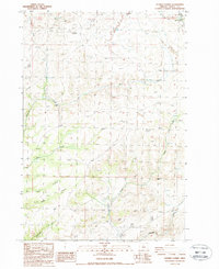 1987 Shaniko Summit1988 Print · USGSWasco County high-desert ranching and canyon lands are captured here in the late twentieth century. Researchers can trace land holdings and natural landmarks like Rooper Ranch, Courthouse Rock, and the historic town site of Shaniko.
End of results
Showing maps 1-4 of 4
Top cities near Shaniko
Frequently asked questions
- What are the different types of historical maps available for Shaniko?
- What is the oldest map of Shaniko?
- Where can I purchase historical maps of Shaniko for my home or office?
- Where can I download high-res historical maps of Shaniko?
- Are there historical topographic maps available for Shaniko?
- Is there historical aerial imagery available for Shaniko?
- Where are historical maps of Shaniko sourced from?