1970s Maps of Shaniko, Oregon
Explore 2 historic maps of Shaniko from the 1970s. These maps offer a rare glimpse into what life looked like during the 1970s — showing old roads, neighborhoods, homes, and landmarks that have changed or disappeared over time.
Whether you're researching your family's past, planning a metal detecting trip, or studying how Shaniko's landscape evolved across the 1970s, these high-resolution maps are a powerful tool for exploring the history of this region.
- Focus on a specific era: All maps on this page are from the 1970s, giving you a focused view of this time period.
- See what’s changed: Compare century-old streets, trails, and buildings to today's modern landscape using overlays and satellite layers.
- Research with precision: Use these maps for genealogy, historical research, land use analysis, or educational projects.
- View, download, or print: Maps are fully viewable online in high resolution, and can be downloaded or printed for your own records.
Start exploring Shaniko's history through authentic maps from the 1970s. This is your window into the past.
Shaniko, OR maps
(2)- 1970 Map of Macken Canyon, 1973 Print
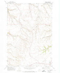
 1970 Macken Canyon1973 Print · USGSThe high desert plateaus along the Wasco and Sherman County line appear here in the early seventies, defined by deep canyons and seasonal springs. Researchers can trace the path of an Old Railroad Grade and locate agricultural landmarks like the lone Grain Elevator and Macken Springs.
 - 1971 Map of Shaniko, 1974 Print
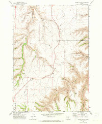
 1971 Shaniko1974 Print · USGSShaniko was an essential hub for Wasco County ranchers and travelers in the early 1970s. Local historians can trace the paths of Bakeoven Road and Jeep Trails to find landmarks like the Hinton-Ward Ranch, the Cem, and Nachter Butte.
End of results
Showing maps 1-2 of 2
Top cities near Shaniko
Frequently asked questions
- What are the different types of historical maps available for Shaniko?
- What is the oldest map of Shaniko?
- Where can I purchase historical maps of Shaniko for my home or office?
- Where can I download high-res historical maps of Shaniko?
- Are there historical topographic maps available for Shaniko?
- Is there historical aerial imagery available for Shaniko?
- Where are historical maps of Shaniko sourced from?