1940s Maps of Straban Township, Pennsylvania
Explore 6 historic maps of Straban Township from the 1940s. These maps offer a rare glimpse into what life looked like during the 1940s — showing old roads, neighborhoods, homes, and landmarks that have changed or disappeared over time.
Whether you're researching your family's past, planning a metal detecting trip, or studying how Straban Township's landscape evolved across the 1940s, these high-resolution maps are a powerful tool for exploring the history of this region.
- Focus on a specific era: All maps on this page are from the 1940s, giving you a focused view of this time period.
- See what’s changed: Compare century-old streets, trails, and buildings to today's modern landscape using overlays and satellite layers.
- Research with precision: Use these maps for genealogy, historical research, land use analysis, or educational projects.
- View, download, or print: Maps are fully viewable online in high resolution, and can be downloaded or printed for your own records.
Start exploring Straban Township's history through authentic maps from the 1940s. This is your window into the past.
Straban Township, PA maps
(6)- 1942 Map of Gettysburg, 1944 Print
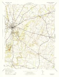
 1942 Gettysburg1944 Print · USGSGettysburg and its surrounding borderlands are shown in great detail during the early 1940s, capturing the region's dense network of rural schools and mills. Genealogists can trace family-named landmarks such as Galt Kump PO, Hafers Mill, and Philips Delight Sch.
 - 1944 Map of Gettysburg
 1944 Gettysburg1944 Print · USGSGettysburg and its surrounding townships appear here in the 1940s, providing a clear look at the battlefield and rural Adams County. Genealogists and historians can trace the terrain of Devils Den, identify small schools like Boyd School, and locate the Hoffman Orphanage.
 - 1944 Map of Mc Sherrystown
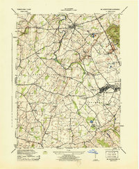 1944 Mc Sherrystown1944 Print · USGSAdams County at the height of the mid-forties reveals a landscape defined by small boroughs, limestone quarries, and rural schoolhouses. Genealogists can trace family locations near Mc Sherrystown, St Joseph Academy, and the rail junction at Berlin Jct.4 unique versions available
 - 1944 Map of Biglerville
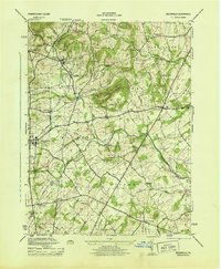 1944 Biglerville1944 Print · USGSAdams County’s orchard country and rail corridors are preserved here at the height of the mid-century fruit packing era. Genealogists and historians can trace family locations near Rock Chapel School, the H G Baugher Fruit Packing Co, and old rail stops like Bendersville Sta.5 unique versions available
 - 1944 Map of Hampton
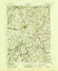 1944 Hampton1944 Print · USGSAdams County townships like Huntington and Straban appear here during the mid-1940s, showing a landscape of small farms and family-named schools. You can trace old property lines and local landmarks from Round Hill School to the banks of Conewago Creek.5 unique versions available
 - 1948 Map of Baltimore
 1948 Baltimore1948 Print · USGSMaryland and Pennsylvania crossroads are captured in the late 1940s, showing a landscape defined by historic rail lines and major military installations. Genealogists can trace family connections in Gettysburg, Westminster, and near the U.S. Naval Academy in Annapolis.2 unique versions available
End of results
Showing maps 1-6 of 6
Top cities near Straban Township
- Hanover historical maps
- Parkville historical maps
- Gettysburg historical maps
- West Manheim Township historical maps
- Taneytown historical maps
- Littlestown historical maps
See more
Top neighborhoods of Straban Township
- Newchester historical maps
- The Pines historical maps
- Guldens historical maps
- Shrivers Corners historical maps
Frequently asked questions
- What are the different types of historical maps available for Straban Township?
- What is the oldest map of Straban Township?
- Where can I purchase historical maps of Straban Township for my home or office?
- Where can I download high-res historical maps of Straban Township?
- Are there historical topographic maps available for Straban Township?
- Is there historical aerial imagery available for Straban Township?
- Where are historical maps of Straban Township sourced from?