1990s Maps of Straban Township, Pennsylvania
Explore 5 historic maps of Straban Township from the 1990s. These maps offer a rare glimpse into what life looked like during the 1990s — showing old roads, neighborhoods, homes, and landmarks that have changed or disappeared over time.
Whether you're researching your family's past, planning a metal detecting trip, or studying how Straban Township's landscape evolved across the 1990s, these high-resolution maps are a powerful tool for exploring the history of this region.
- Focus on a specific era: All maps on this page are from the 1990s, giving you a focused view of this time period.
- See what’s changed: Compare century-old streets, trails, and buildings to today's modern landscape using overlays and satellite layers.
- Research with precision: Use these maps for genealogy, historical research, land use analysis, or educational projects.
- View, download, or print: Maps are fully viewable online in high resolution, and can be downloaded or printed for your own records.
Start exploring Straban Township's history through authentic maps from the 1990s. This is your window into the past.
Straban Township, PA maps
(5)- 1990 Map of Mc Sherrystown, 1995 Print
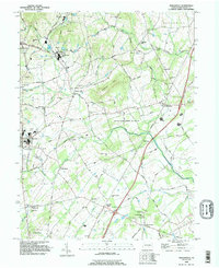
 1990 Mc Sherrystown1995 Print · USGSThe Adams County countryside surrounding McSherrystown and New Oxford in the early nineties reveals a blend of farming, quarrying, and historic crossroads. Genealogists can locate family landmarks like Hostetters Meeting House, Low Dutch Cem, and the St Joseph Academy.
 - 1990 Map of Hampton, 1995 Print
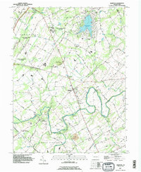 1990 Hampton1995 Print · USGSAdams County’s rural landscape is captured here in the early nineties, showcasing the area's transition between agricultural tradition and modern development. Genealogists can locate family sites near New Chester, St Johns Ch, and the many cemeteries dotting the banks of Conewago Creek.
 - 1990 Map of Biglerville, 1995 Print
 1990 Biglerville1995 Print · USGSThe orchard country of Adams County is captured here in the early nineties, showing a landscape of established villages and rising hills. Genealogists and historians can trace family locations near Rock Chapel, find the Bendersville Sta rail point, or locate old sites like Limerick Mill.
 - 1990 Map of Gettysburg, 1995 Print
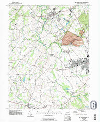
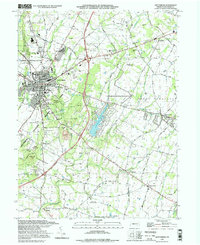
 1990 Gettysburg1995 Print · USGSGettysburg and its surrounding townships appear here in the 1990s, Balancing its legacy as a memorial site with modern growth. Historians can trace landmark sites like Devils Den and Spanglers Spring alongside the Gettysburg Railroad and Hoffman Orphanage.
 - 1994 Map of Gettysburg, 1998 Print
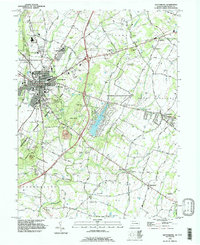
 1994 Gettysburg1998 Print · USGSGettysburg and its surrounding townships appear here in the mid-nineties, balancing a preserved Civil War landscape with a growing modern community. Researchers can trace historic landmarks from Devils Den and Culps Hill to the Hoffman Orphanage and the Gettysburg Railroad.
End of results
Showing maps 1-5 of 5
Top cities near Straban Township
- Hanover historical maps
- Parkville historical maps
- Gettysburg historical maps
- West Manheim Township historical maps
- Taneytown historical maps
- Littlestown historical maps
See more
Top neighborhoods of Straban Township
- Newchester historical maps
- The Pines historical maps
- Guldens historical maps
- Shrivers Corners historical maps
Frequently asked questions
- What are the different types of historical maps available for Straban Township?
- What is the oldest map of Straban Township?
- Where can I purchase historical maps of Straban Township for my home or office?
- Where can I download high-res historical maps of Straban Township?
- Are there historical topographic maps available for Straban Township?
- Is there historical aerial imagery available for Straban Township?
- Where are historical maps of Straban Township sourced from?