1990s Maps of Armstrong County, Pennsylvania
Explore 9 historic maps of Armstrong County from the 1990s. These maps offer a rare glimpse into what life looked like during the 1990s — showing old roads, neighborhoods, homes, and landmarks that have changed or disappeared over time.
Whether you're researching your family's past, planning a metal detecting trip, or studying how Armstrong County's landscape evolved across the 1990s, these high-resolution maps are a powerful tool for exploring the history of this region.
- Focus on a specific era: All maps on this page are from the 1990s, giving you a focused view of this time period.
- See what’s changed: Compare century-old streets, trails, and buildings to today's modern landscape using overlays and satellite layers.
- Research with precision: Use these maps for genealogy, historical research, land use analysis, or educational projects.
- View, download, or print: Maps are fully viewable online in high resolution, and can be downloaded or printed for your own records.
Start exploring Armstrong County's history through authentic maps from the 1990s. This is your window into the past.
Armstrong County, PA maps
(9)- 1993 Map of Freeport
 1993 Freeport1993 Print · USGSThe confluence of the Allegheny and Kiskiminetas Rivers defines the industrial landscape of southwestern Pennsylvania in the early nineties. Researchers can trace the riverfront rail lines of CONRAIL, find old family burial grounds like Mud Church Cem, and locate the historic Garvers Ferry site.
 - 1993 Map of East Brady
 1993 East Brady1993 Print · USGSThe Allegheny River corridor in the early nineties reveals a landscape shaped by river transport and deep-vein mining. Researchers can trace family roots at St Eusebius Cem, locate the Sugarcreek Sch, or explore riverside hamlets like Wattersonville and Philipston.
 - 1993 Map of Vandergrift
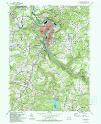 1993 Vandergrift1993 Print · USGSThe Kiskiminetas River valley comes alive in the early nineties, showing the industrial density of Vandergrift and its neighboring boroughs. Genealogists and local historians can trace family locations near the Saints Cosmas & Damian Shrine, identify burial sites at Apollo Cem, or locate the historic Fort Hand Historical Marker.
 - 1993 Map of Worthington
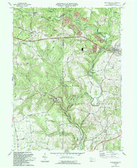 1993 Worthington1993 Print · USGSArmstrong and Butler counties are captured here in the early nineties as rural communities and light industry meet. Genealogists can trace family names at Slate Lick, Fenelton, and St Johns Ch or follow the historic Buffalo Mills along the creek.
 - 1993 Map of Kittanning
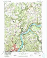
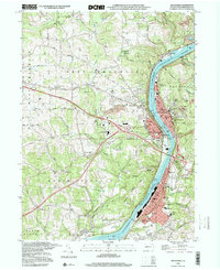
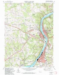 1993 Kittanning1993 Print · USGSArmstrong County in the 1990s was a landscape shaped by the Allegheny River and a legacy of industry. Genealogists and historians can trace family roots through numerous sites like Lawnheaven Cem, Wick City, and the St Pauls Monastery.
 - 1998 Map of Avonmore, 1999 Print
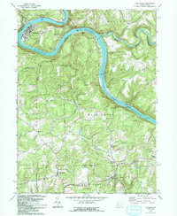
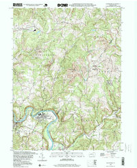 1998 Avonmore1999 Print · USGSThe loop of the Kiskiminetas River defines this landscape in the late nineties, where coal-rich townships meet the river's bend. Genealogists and historians can trace the foundations of local life through the Spring Church, West View Cem, and the Elders Ridge Joint High Sch.
 - 1998 Map of Vandergrift, 2000 Print
 1998 Vandergrift2000 Print · USGSThe industrial corridor of the Kiskiminetas River is shown in great detail during the late 1990s as it winds past Vandergrift and Apollo. Researchers can locate specific sites like the Fort Hand Historical Marker, Pleasant Hill Cemetery, and the Saints Cosmas & Damian Shrine.
 - 1998 Map of Freeport, 2000 Print
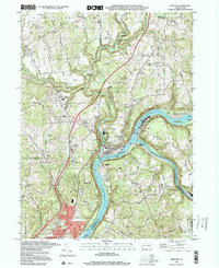 1998 Freeport2000 Print · USGSThe confluence of the Allegheny and Kiskiminetas rivers at the end of the century shows a landscape of deep rail history and industrial riverfronts. Trace family roots at Mount Airy Cemetery or locate old valley crossings like Garvers Ferry and Butler Junction.
 - 1998 Map of Kittanning, 2000 Print
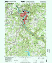
 1998 Kittanning2000 Print · USGSArmstrong County’s riverfront industrial corridor is captured here at the end of the century, showing the tight-knit settlements along the Allegheny. Researchers can trace local roots through St Pauls Monastery, Dog Town, and Holy Trinity Cem.
End of results
Showing maps 1-9 of 9
Top cities of Armstrong County
- Kittanning historical maps
- Ford City historical maps
- North Buffalo Township historical maps
- Leechburg historical maps
- Freeport historical maps
- West Kittanning historical maps
See more
Frequently asked questions
- What are the different types of historical maps available for Armstrong County?
- What is the oldest map of Armstrong County?
- Where can I purchase historical maps of Armstrong County for my home or office?
- Where can I download high-res historical maps of Armstrong County?
- Are there historical topographic maps available for Armstrong County?
- Is there historical aerial imagery available for Armstrong County?
- Where are historical maps of Armstrong County sourced from?