Old Maps of Beaver County, Pennsylvania for Genealogy
Trace your family roots with 73 historic maps of Beaver County. These high-res maps reveal old neighborhoods, homesites, landmarks, and streets — helping you uncover where your ancestors lived and how the area evolved over time.
- Explore historic neighborhoods: Identify where your relatives may have lived in the 1800s or 1900s.
- Compare maps over time: Trace the changes in streets, buildings, and landmarks for multi-generational research.
- Perfect for genealogy & ancestry research: Used by family historians and researchers to map out lineage and migration.
These maps are an incredible resource for exploring your personal connection to Beaver County's past.
Beaver County, PA maps
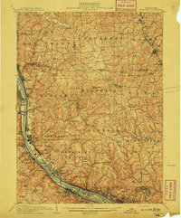
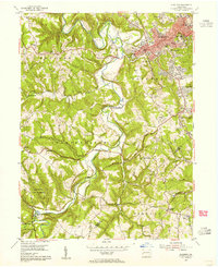
(73)- 1901 Map of Beaver, 1958 Print
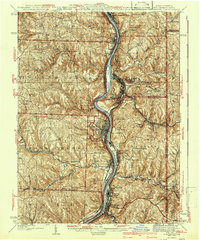
 1901 Beaver1958 Print · USGSThe industrial river valleys of Beaver County at the dawn of the twentieth century are captured here in meticulous detail. Researchers can trace the development of Beaver Falls and Rochester or locate riverside landmarks like Baker's Landing and Dam No. 6.
 - 1902 Map of New Castle, 1956 Print
 1902 New Castle1956 Print · USGSLawrence and Beaver counties were industrial powerhouses at the turn of the century, defined by a massive intersection of river and rail. Researchers can trace the complex rail networks of the Pennsylvania RR and find historic hubs like New Castle, Ellwood City, and New Galilee.
 - 1904 Map of Newcastle
 1904 Newcastle1904 Print · USGSLawrence and Beaver Counties are captured at a peak of industrial expansion during the early 1900s, when the river valleys were heavy with rail traffic. Genealogists and historians can trace the early footprints of Newcastle, the remote Thompson Run Mines, and the vanished Irish Ripple Newport PO.6 unique versions available
 - 1904 Map of Wellsville
 1904 Wellsville1904 Print · USGSThe tri-state border region along the OHIO RIVER is captured here during the peak of its rail-and-river expansion. Genealogists can trace family footprints in Wellsville or find early rural landmarks like Grimm's Bridge and Cannon's Mill.3 unique versions available
 - 1904 Map of Steubenville
 1904 Steubenville1904 Print · USGSThe industrial heart of the Ohio River Valley comes to life in this early 1900s survey of the tri-state border region. Genealogists and historians can trace the early footprints of Steubenville, the rail junctions at Mingo Junction, and river crossings like Middle Ferry.5 unique versions available
 - 1904 Map of Beaver
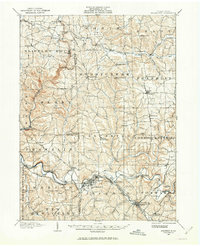
 1904 Beaver1904 Print · USGSBeaver County at the opening of the twentieth century shows a landscape defined by the bustling industrial corridors of the Ohio River. Genealogists can trace family roots through riverfront settlements like Monaca, Shippingport, and Freedom, or locate early transport hubs such as Cooks Ferry.6 unique versions available
 - 1904 Map of Burgettstown, 1958 Print
 1904 Burgettstown1958 Print · USGSWashington County and its neighbors are documented at the turn of the century as the coal and rail industries began reshaping the landscape. Researchers can trace early family sites and infrastructure from Pattersons Mill to the Francis Mine and the North Star Tyre P O.
 - 1906 Map of Burgettstown
 1906 Burgettstown1906 Print · USGSWestern Pennsylvania’s coal and rail landscape comes into focus at the dawn of the twentieth century. Researchers can trace historic family landmarks and industrial sites like Francis Mine, Pattersons Mill, and the North Star Tyre P O.5 unique versions available
 - 1906 Map of Sewickley, 1960 Print
 1906 Sewickley1960 Print · USGSWestern Pennsylvania’s river-and-rail corridor is captured here at the start of the century, showing the industrial development along the Ohio River. Researchers can trace early infrastructure like Dam No 4 or locate landmarks such as the Camp Meeting Grounds and Parks Quarries.
 - 1907 Map of Columbiana, 1958 Print
 1907 Columbiana1958 Print · USGSColumbiana County at the turn of the century was a bustling corridor of coal, rail, and community life. Genealogists can trace family names at Subrosa School and Mt Zion Church, or locate defunct stops on the Pennsylvania System.
 - 1908 Map of Sewickley
 1908 Sewickley1908 Print · USGSThe industrial corridor of the Ohio River valley is captured here in the early twentieth century, showing a landscape defined by steam-era transport and valley settlements. Researchers can trace the riverfront rail networks of the Pennsylvania System and locate historic landmarks like Aliquippa Park and the Campmeeting Grounds.7 unique versions available
 - 1908 Map of Zelienople, 1963 Print
 1908 Zelienople1963 Print · USGSButler County and parts of Lawrence and Beaver Counties are shown in the first decade of the 1900s, when the region's river-and-rail economy was in full swing. Genealogists and historians can trace family roots at McConnells Mill, locate schools like Tollgate School, or explore the early streets of Zelienople and Harmony.
 - 1909 Map of Columbiana, 1937 Print
 1909 Columbiana1937 Print · USGSThe Ohio-Pennsylvania borderlands are captured here during the peak of the rail era, showing a landscape defined by industry and rural education. Researchers can trace the path of the Pennsylvania System through East Palestine or locate local landmarks like Coalmines and the Subrosa School.2 unique versions available
 - 1910 Map of Zelienople
 1910 Zelienople1910 Print · USGSWestern Pennsylvania in the early twentieth century is a landscape of thriving creek-side towns and intersecting rail lines. Genealogists can trace family roots through numerous rural landmarks like McConnells Mill, Zion Church, and the many country schoolhouses including American School.5 unique versions available
 - 1935 Map of Steubenville, 1958 Print
 1935 Steubenville1958 Print · USGSThe industrial heart of the Ohio River valley comes to life in this mid-century survey of the Ohio, West Virginia, and Pennsylvania borders. Genealogists and historians can trace the early footprints of Weirton, Steubenville, and smaller stops like Zalia and Reeds Mills.
 - 1937 Map of Wellsville, 1960 Print
 1937 Wellsville1960 Print · USGSThe Ohio River valley thrives as a Tri-State industrial hub in the years before the Second World War. Researchers can trace the riverfront rail lines of the Pennsylvania RR and locate vanished local landmarks like Pughtown PO and Nessly Chapel.
 - 1942 Map of Steubenville
 1942 Steubenville1942 Print · USGSThe industrial corridor of the upper Ohio River comes to life here during the early 1940s. Genealogists can trace family roots through the streets of Steubenville and Weirton, or locate rural landmarks like Jefferson Sch and New Alexandria Sta.2 unique versions available
 - 1944 Map of Wellsville
 1944 Wellsville1944 Print · USGSThe industrial heart of the Ohio River valley comes to life in the 1940s, showing the bustling riverfronts of Wellsville and East Liverpool. Researchers can trace the Pennsylvania RR lines and find local landmarks like Grimms Bridge and Pughtown PO.2 unique versions available
 - 1951 Map of Canton
 1951 Canton1951 Print · USGSThe industrial heartland of Ohio and Pennsylvania reached its mid-century peak during this era of heavy rail and river transit. Genealogists and historians can trace the development of steel towns like Aliquippa and Weirton alongside the Ohio River and major lines of the Pennsylvania RR.
 - 1953 Map of Canton
 1953 Canton1953 Print · USGSThe industrial heartland of Ohio and Pennsylvania is captured at its mid-century peak in this detailed regional survey. Genealogists and historians can trace the vast rail networks of the Pennsylvania RR and find local landmarks like Nimisila Reservoir and Tappan Reservoir.
 - 1953 Map of Ambridge, 1955 Print
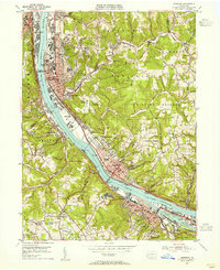 1953 Ambridge1955 Print · USGSThe Ohio River valley in the early fifties is captured here at a peak of industrial and rail activity. Local historians can trace the grounds of Old Economy, locate the Dashields Dam, and find vanished landmarks like Stoops Ferry.
 - 1953 Map of Beaver, 1955 Print
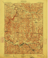
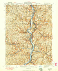
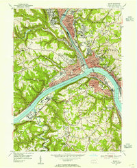 1953 Beaver1955 Print · USGSThe industrial river valleys of Pennsylvania are captured here in the early fifties as the rail and steel economy thrived. Researchers can trace family roots through numerous sites like St Cecilias Cem, Beaver High Sch, and the Conway Yard.4 unique versions available
 - 1953 Map of Baden, 1955 Print
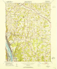 1953 Baden1955 Print · USGSThe industrial riverfronts and rural uplands of Beaver County meet in the early 1950s along the Ohio River. Researchers can trace the rail networks of the Pennsylvania and local landmarks like Mt Gallitzin Academy and Big Knob Grange.7 unique versions available
 - 1954 Map of Aliquippa, 1955 Print
 1954 Aliquippa1955 Print · USGSBeaver County’s industrial valleys and rural uplands meet in the mid-fifties, showing the growth of Aliquippa alongside established farming communities. Genealogists can trace family names through the John Anderson Memorial Cem, New Bethlehem Ch, and the rural crossroads of Gringo.6 unique versions available
 - 1954 Map of Hookstown, 1955 Print
 1954 Hookstown1955 Print · USGSBeaver County at the mid-century reveals a landscape of river-front industry and settled country ridges. Genealogists can trace the rural communities of Hookstown and Mechanicsburg via the Lincoln Highway to local landmarks like Mill Creek Ch and Reed Sch.5 unique versions available
Showing maps 1-25 of 73
Top cities of Beaver County
- Center Township historical maps
- Aliquippa historical maps
- Beaver Falls historical maps
- Economy historical maps
- Ambridge historical maps
- Monaca historical maps
See more
Frequently asked questions
- What are the different types of historical maps available for Beaver County?
- What is the oldest map of Beaver County?
- Where can I purchase historical maps of Beaver County for my home or office?
- Where can I download high-res historical maps of Beaver County?
- Are there historical topographic maps available for Beaver County?
- Is there historical aerial imagery available for Beaver County?
- Where are historical maps of Beaver County sourced from?