1940s Maps of Maxatawny Township, Pennsylvania
Explore 6 historic maps of Maxatawny Township from the 1940s. These maps offer a rare glimpse into what life looked like during the 1940s — showing old roads, neighborhoods, homes, and landmarks that have changed or disappeared over time.
Whether you're researching your family's past, planning a metal detecting trip, or studying how Maxatawny Township's landscape evolved across the 1940s, these high-resolution maps are a powerful tool for exploring the history of this region.
- Focus on a specific era: All maps on this page are from the 1940s, giving you a focused view of this time period.
- See what’s changed: Compare century-old streets, trails, and buildings to today's modern landscape using overlays and satellite layers.
- Research with precision: Use these maps for genealogy, historical research, land use analysis, or educational projects.
- View, download, or print: Maps are fully viewable online in high resolution, and can be downloaded or printed for your own records.
Start exploring Maxatawny Township's history through authentic maps from the 1940s. This is your window into the past.
Maxatawny Township, PA maps
(6)- 1942 Map of Allentown West
 1942 Allentown West1942 Print · USGSLehigh County during the early war years displays a landscape of industrial river towns and agrarian crossroads. Researchers can locate dozens of country schools like Snyder Sch, historic landmarks like Cedar Crest College, and the sprawling Trexler Game Preserve.3 unique versions available
 - 1943 Map of Manatawny
 1943 Manatawny1943 Print · USGSBerks County's rural townships are captured in detail during the early war years, showing a landscape of traditional farmsteads and small crossroads communities. Genealogists and historians can trace family locations near Hill Church, Landis Store, and along the Reading rail line.
 - 1944 Map of Reading
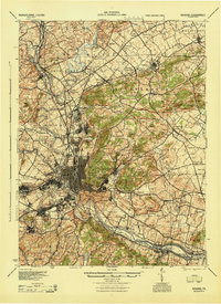 1944 Reading1944 Print · USGSReading and its surrounding Berks County townships appear here during the height of the mid-century industrial era. Genealogists and historians can trace family locations through dozens of named schools like Shirk Sch and Cedar top Sch, or locate ancestral sites at Oley Furnace and Charles Evans Cem.
 - 1944 Map of Newark, 1971 Print
 1944 Newark1971 Print · USGSThe industrial corridor from Philadelphia to New York was in a period of massive transition during the mid-forties. Genealogists and researchers can trace the rail lines of the Lehigh Valley RR, locate military installations like Picatinny Arsenal, and explore the early sprawl near Levittown.5 unique versions available
 - 1946 Map of Reading
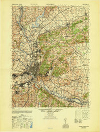 1946 Reading1946 Print · USGSBerks County's industrial and agricultural heartland is documented here just after the war, centered on the bustling hub of Reading. Genealogists and historians can trace family-named landmarks like Hecktown Sch, Friends Meeting House, and Van Reeds Mill.
 - 1949 Map of Newark
 1949 Newark1949 Print · USGSThe industrial corridor between Philadelphia and New York comes alive in this post-war survey. Genealogists and historians can trace the massive rail networks of the Reading Railroad and locate major installations like Fort Dix or Picatinny Arsenal.2 unique versions available
End of results
Showing maps 1-6 of 6
Top cities near Maxatawny Township
- Allentown historical maps
- Reading historical maps
- Muhlenberg Park historical maps
- Wyomissing historical maps
- New Hanover Township historical maps
- Longswamp Township historical maps
See more
Top neighborhoods of Maxatawny Township
- Hinterleiter historical maps
- Mill Creek Corner historical maps
- Bowers historical maps
- Eagle Point historical maps
- Schofer historical maps
- Five Points historical maps
See more
Frequently asked questions
- What are the different types of historical maps available for Maxatawny Township?
- What is the oldest map of Maxatawny Township?
- Where can I purchase historical maps of Maxatawny Township for my home or office?
- Where can I download high-res historical maps of Maxatawny Township?
- Are there historical topographic maps available for Maxatawny Township?
- Is there historical aerial imagery available for Maxatawny Township?
- Where are historical maps of Maxatawny Township sourced from?