1990s Maps of Maxatawny Township, Pennsylvania
Explore 4 historic maps of Maxatawny Township from the 1990s. These maps offer a rare glimpse into what life looked like during the 1990s — showing old roads, neighborhoods, homes, and landmarks that have changed or disappeared over time.
Whether you're researching your family's past, planning a metal detecting trip, or studying how Maxatawny Township's landscape evolved across the 1990s, these high-resolution maps are a powerful tool for exploring the history of this region.
- Focus on a specific era: All maps on this page are from the 1990s, giving you a focused view of this time period.
- See what’s changed: Compare century-old streets, trails, and buildings to today's modern landscape using overlays and satellite layers.
- Research with precision: Use these maps for genealogy, historical research, land use analysis, or educational projects.
- View, download, or print: Maps are fully viewable online in high resolution, and can be downloaded or printed for your own records.
Start exploring Maxatawny Township's history through authentic maps from the 1990s. This is your window into the past.
Maxatawny Township, PA maps
(4)- 1997 Map of Kutztown, 1999 Print
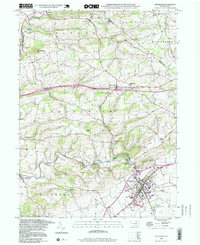 1997 Kutztown1999 Print · USGSKutztown and the surrounding Berks County farmlands are captured here in the late twentieth century. Researchers can trace the legacy of local education and faith at Kutztown State Teachers College, Moselem Ch, and the Old Order Ch.
 - 1999 Map of Topton, 2001 Print
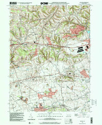 1999 Topton2001 Print · USGSThe Berks and Lehigh county line comes alive in the late nineties, documenting a landscape of established farmsteads and rural boroughs. Genealogists can trace family roots through historic sites like Shamrock Station, St Pauls Church, and Leather Corner Post.
 - 1999 Map of Fleetwood, 2001 Print
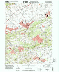 1999 Fleetwood2001 Print · USGSBerks County at the end of the millennium retains its distinct pattern of rural schoolhouses and furnace hamlets. Genealogists can locate family landmarks like Lesher Cem, Dreibelbis Sch, and the historic industrial site at Oley Furnace.
 - 1999 Map of Manatawny, 2002 Print
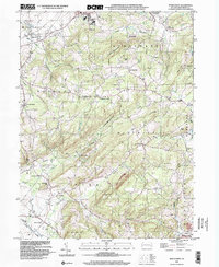 1999 Manatawny2002 Print · USGSBerks County's rural townships are documented here during the late twentieth century, showing a landscape of ridgelines and small valleys. Researchers can locate family landmarks like Mountain Marys Grave, Hill Church, and the village of Landis Store.
End of results
Showing maps 1-4 of 4
Top cities near Maxatawny Township
- Allentown historical maps
- Reading historical maps
- Muhlenberg Park historical maps
- Wyomissing historical maps
- New Hanover Township historical maps
- Longswamp Township historical maps
See more
Top neighborhoods of Maxatawny Township
- Hinterleiter historical maps
- Mill Creek Corner historical maps
- Bowers historical maps
- Eagle Point historical maps
- Schofer historical maps
- Five Points historical maps
See more
Frequently asked questions
- What are the different types of historical maps available for Maxatawny Township?
- What is the oldest map of Maxatawny Township?
- Where can I purchase historical maps of Maxatawny Township for my home or office?
- Where can I download high-res historical maps of Maxatawny Township?
- Are there historical topographic maps available for Maxatawny Township?
- Is there historical aerial imagery available for Maxatawny Township?
- Where are historical maps of Maxatawny Township sourced from?