1960s Maps of Blair County, Pennsylvania
Explore 19 historic maps of Blair County from the 1960s. These maps offer a rare glimpse into what life looked like during the 1960s — showing old roads, neighborhoods, homes, and landmarks that have changed or disappeared over time.
Whether you're researching your family's past, planning a metal detecting trip, or studying how Blair County's landscape evolved across the 1960s, these high-resolution maps are a powerful tool for exploring the history of this region.
- Focus on a specific era: All maps on this page are from the 1960s, giving you a focused view of this time period.
- See what’s changed: Compare century-old streets, trails, and buildings to today's modern landscape using overlays and satellite layers.
- Research with precision: Use these maps for genealogy, historical research, land use analysis, or educational projects.
- View, download, or print: Maps are fully viewable online in high resolution, and can be downloaded or printed for your own records.
Start exploring Blair County's history through authentic maps from the 1960s. This is your window into the past.
Blair County, PA maps
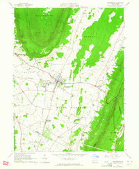
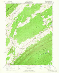
(19)- 1961 Map of Ashville, 1963 Print
 1961 Ashville1963 Print · USGSThe Allegheny Front in the early sixties was a landscape defined by the Pennsylvania Railroad and the coal mining industry. Genealogists and local historians can trace family roots through the clusters of churches and cemeteries at Ashville, Spindley City, and Coupon.3 unique versions available
 - 1963 Map of Martinsburg, 1964 Print
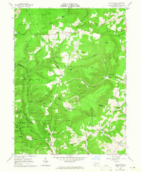
 1963 Martinsburg1964 Print · USGSThe valleys and ridges of Blair County are captured here in the early sixties, showing a landscape of small farms and crossroads settlements. Genealogists can trace family names at the Detwiler Cem or Nicodemus Cem and locate landmarks like Central High Sch.3 unique versions available
 - 1963 Map of Entriken, 1964 Print
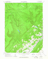
 1963 Entriken1964 Print · USGSHuntsville's river valleys and ridgelines are captured here in the early sixties, showing the Raystown Branch Juniata River before major reservoir changes. Genealogists can locate family names at Brumbaugh Cem and community hubs like Salems Ch and Lincoln Grange Hall.5 unique versions available
 - 1963 Map of Tipton, 1965 Print
 1963 Tipton1965 Print · USGSThe Little Juniata River valley near Tyrone was a bustling transit corridor in the early 1960s. Researchers can trace the Pennsylvania railroad line through Grazierville and Tipton, or locate historic sites like the Fox Cem and a Covered Bridge.3 unique versions available
 - 1963 Map of Spruce Creek, 1965 Print
 1963 Spruce Creek1965 Print · USGSBlair and Huntingdon counties in the early sixties show a landscape shaped by narrow valleys and the legacy of the iron industry. Genealogists and historians can trace the foundations of Etna Furnace, locate the St John Cem, and follow the old rail lines through Union Furnace.4 unique versions available
 - 1963 Map of Hollidaysburg, 1965 Print
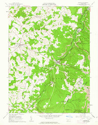
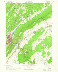
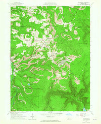
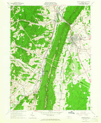
 1963 Hollidaysburg1965 Print · USGSBlair County’s mid-century industrial and suburban growth is on full display during this era of rail and road expansion. Researchers can trace institutional landmarks like Hollidaysburg State Hospital and iconic engineering feats such as the Horseshoe Curve.5 unique versions available
 - 1963 Map of Cresson, 1965 Print
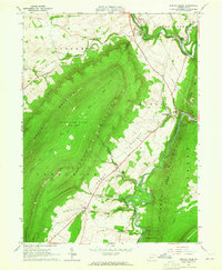
 1963 Cresson1965 Print · USGSThe Allegheny Front was a beehive of coal mining and rail engineering in the early sixties. Genealogists and historians can trace family roots at St Aloysius Ch, locate the grounds of the Lawrence Flick State Hospital, or follow the Pennsylvania railroad tracks through Tunnel Hill.6 unique versions available
 - 1963 Map of Tyrone, 1965 Print
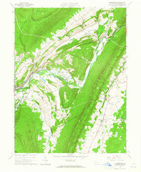
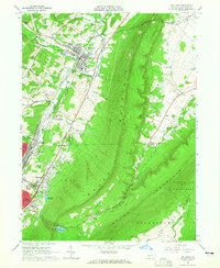
 1963 Tyrone1965 Print · USGSIn the early 1960s, the industrial corridor along the Little Juniata River was a hub of transit and production. Trace the rail lines and old roads through Tyrone, Warriors Mark, and Birmingham, or locate family landmarks like Baughman Cem and Grier Sch.4 unique versions available
 - 1963 Map of Altoona, 1965 Print
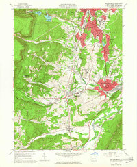
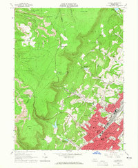 1963 Altoona1965 Print · USGSAltoona and its mountain suburbs are captured here in the early sixties, showing the city's transition from a rail industrial center to a regional academic and civic hub. Researchers can trace family roots through numerous parish schools and cemeteries or locate defunct mountain settlements like Wopsononock and Highland Fling.6 unique versions available
 - 1963 Map of Blue Knob, 1965 Print
 1963 Blue Knob1965 Print · USGSThe high ridges of the Allegheny Front come into sharp focus in the early sixties as recreational spaces like Blue Knob State Park expand alongside traditional mountain settlements. Genealogists can trace family landmarks like Stiefler Corner and the Lost Cox Children Monument among the hollows of Bobs Creek.4 unique versions available
 - 1963 Map of Blandburg, 1965 Print
 1963 Blandburg1965 Print · USGSThe coal and rail landscape of the Allegheny Front comes to life in the early 1960s, showing the intersection of industry and rural life. Trace family roots at Roseland Ch and Cambria Mills Cem, or locate mining heritage through the Tipple and Strip Mines near Blandburg.4 unique versions available
 - 1963 Map of Frankstown, 1965 Print
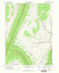
 1963 Frankstown1965 Print · USGSBlair County in the early sixties shows a landscape where mountain ridges channel river life and industrial extraction. You can trace the remnants of an old railroad grade or locate ancestral sites like Eight Square Chapel and Royer Cem.4 unique versions available
 - 1963 Map of Franklinville, 1965 Print
 1963 Franklinville1965 Print · USGSCentral Pennsylvania’s industrial and agricultural valleys are captured here in the early sixties. Researchers can trace the heritage of Pennsylvania Furnace and locate landmark sites like Indian Caverns and Warriors Mark Airport.3 unique versions available
 - 1963 Map of Williamsburg, 1965 Print
 1963 Williamsburg1965 Print · USGSThe valleys of Blair and Huntingdon Counties are captured here in the early sixties, showing a landscape of deep-rooted settlements and railroad corridors. Genealogists can trace family names at Snively Cem, Biddle Cem, and the crossing at Brumhaugh Crossing.5 unique versions available
 - 1963 Map of Roaring Spring, 1965 Print
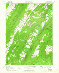
 1963 Roaring Spring1965 Print · USGSThe valleys between DUNNING MOUNTAIN and SHORT MOUNTAIN were centers of industry and community in the early sixties. Researchers can trace family sites from Bakers Summit to Roaring Spring, locating Stowberger Cem, Albright Ch, and numerous local Quarries.4 unique versions available
 - 1963 Map of Bellwood, 1965 Print
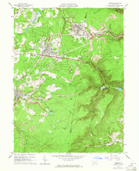
 1963 Bellwood1965 Print · USGSBlair County’s industrial and rail heart beats along the Little Juniata River during the early sixties. Genealogists and local historians can trace the foundations of Bellwood and East Altoona, alongside landmarks like Blair Mem Park (Cem) and the Pennsylvania Railroad.4 unique versions available
 - 1964 Map of Pittsburgh
 1964 Pittsburgh1964 Print · USGSWestern Pennsylvania in the late fifties and early sixties shows a landscape of powerful river industries and expanding highways. Genealogists and historians can trace the rail corridors of the Pennsylvania RR through industrial hubs like Johnstown, Altoona, and Nanty Glo.
 - 1968 Map of New Enterprise, 1970 Print
 1968 New Enterprise1970 Print · USGSMorrison Cove in the late sixties remains a landscape of tightly-knit valley settlements and steep ridges. Researchers can trace family history at Potter Creek Cem or locate community landmarks like New Enterprise and the St Marks-Union Ch.3 unique versions available
 - 1968 Map of Hopewell, 1970 Print
 1968 Hopewell1970 Print · USGSThe Raystown Branch Juniata River corridor is shown in detail during the late sixties, capturing the industrial and rural character of Bedford County. Local researchers can trace the H & B T M RR line through Hopewell and locate family landmarks like Smith Sch and St Lukes Cem.3 unique versions available
End of results
Showing maps 1-19 of 19
Top cities of Blair County
- Altoona historical maps
- Frankstown Township historical maps
- Hollidaysburg historical maps
- Tyrone historical maps
- Roaring Spring historical maps
- Martinsburg historical maps
See more
Frequently asked questions
- What are the different types of historical maps available for Blair County?
- What is the oldest map of Blair County?
- Where can I purchase historical maps of Blair County for my home or office?
- Where can I download high-res historical maps of Blair County?
- Are there historical topographic maps available for Blair County?
- Is there historical aerial imagery available for Blair County?
- Where are historical maps of Blair County sourced from?