1990s Maps of Blair County, Pennsylvania
Explore 5 historic maps of Blair County from the 1990s. These maps offer a rare glimpse into what life looked like during the 1990s — showing old roads, neighborhoods, homes, and landmarks that have changed or disappeared over time.
Whether you're researching your family's past, planning a metal detecting trip, or studying how Blair County's landscape evolved across the 1990s, these high-resolution maps are a powerful tool for exploring the history of this region.
- Focus on a specific era: All maps on this page are from the 1990s, giving you a focused view of this time period.
- See what’s changed: Compare century-old streets, trails, and buildings to today's modern landscape using overlays and satellite layers.
- Research with precision: Use these maps for genealogy, historical research, land use analysis, or educational projects.
- View, download, or print: Maps are fully viewable online in high resolution, and can be downloaded or printed for your own records.
Start exploring Blair County's history through authentic maps from the 1990s. This is your window into the past.
Blair County, PA maps
(5)- 1993 Map of Altoona, 1998 Print
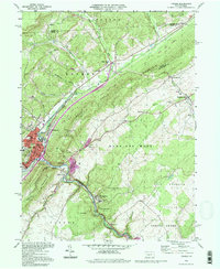
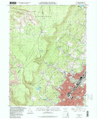 1993 Altoona1998 Print · USGSAltoona and the steep Allegheny Front are captured here in the 1990s as the city expanded its residential footprint into the surrounding hills. Genealogists and local historians can trace legacy neighborhoods and institutions like Agudath Achim Cem, Logan Sch, and Grandview Cemetery.
 - 1994 Map of Franklinville, 1997 Print
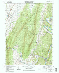
 1994 Franklinville1997 Print · USGSThe valleys of Central Pennsylvania near Pennsylvania Furnace and Huntingdon Furnace are captured here in the 1990s. Genealogists and historians can trace old homesteads, rural landmarks like Indian Caverns, and the Old Halfmoon Railroad Grade.
 - 1994 Map of Frankstown, 1997 Print
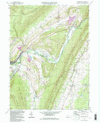 1994 Frankstown1997 Print · USGSThe Juniata River valley in Blair County comes alive in the mid-1990s, showing a landscape of deep-rooted rural settlements and mountain ridges. Researchers can trace family history at Royer Cem, locate the Township Sch, and follow the Penn Central Frankstown Branch railroad.
 - 1994 Map of Hopewell, 1997 Print
 1994 Hopewell1997 Print · USGSThe valleys and ridges of Bedford County are captured here in the mid-1990s, centered on the river settlements of the Juniata. Researchers can locate dozens of ancestral sites, including Replogle Cem, Smith Sch, and the riverside community of Stonerstown.
 - 1994 Map of Tyrone, 1997 Print
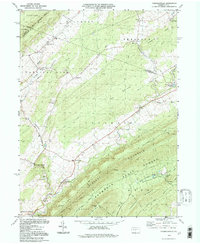
 1994 Tyrone1997 Print · USGSThe rail and mountain landscape of Blair and Huntingdon counties comes alive in this mid-nineties survey of a vital Pennsylvania corridor. Researchers can trace family history at Eastlawn Cem or locate old industrial hamlets like Tyrone Forge and Ironville.
End of results
Showing maps 1-5 of 5
Top cities of Blair County
- Altoona historical maps
- Frankstown Township historical maps
- Hollidaysburg historical maps
- Tyrone historical maps
- Roaring Spring historical maps
- Martinsburg historical maps
See more
Frequently asked questions
- What are the different types of historical maps available for Blair County?
- What is the oldest map of Blair County?
- Where can I purchase historical maps of Blair County for my home or office?
- Where can I download high-res historical maps of Blair County?
- Are there historical topographic maps available for Blair County?
- Is there historical aerial imagery available for Blair County?
- Where are historical maps of Blair County sourced from?