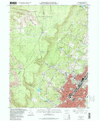
1993 Map of Altoona
USGS Topo · Published 1998About this map
The dense urban grid of Altoona and its immediate suburbs, including Wehnwood and Fairview, dominate the southeastern valley floor in this early 1990s record. To the northwest, the terrain rises sharply toward the Allegheny Front, where high-altitude sites like Wopsononock and Highland Fling overlook a landscape transitioning into protected forest. The map reflects a long history of industrial land use, clearly marking numerous areas as Reclaimed Strip Mine alongside active and former strip mines near Dean and Dougherty. Educational and community anchors are prominent, from the Penn State University (Altoona Campus) to the Jaffa Mosque and Mercy Hospital. Water management for the growing city is evidenced by a network of reservoirs tucked into the gaps of the plateau, including Mill Run Reservoir and Homer Gap Reservoirs.
Find a feature on this map
93 named features on this map. Tap any name to fly to it.
Don’t see what you’re looking for? This feature index may not catch every label — zoom into the map to look around manually.
Map Details
Editions of this 1993 Altoona Map
This is the sole edition of this map. No revisions or reprints were ever made.
Other maps of this area

1902 · Ebensburg
USGS Topo · 1:62,500

1902 · Patton
USGS Topo · 1:62,500

1902 · Hollidaysburg
USGS Topo · 1:62,500

1903 · Hollidaysburg
USGS Topo · 1:62,500

1904 · Patton
USGS Topo · 1:62,500

1904 · Ebensburg
USGS Topo · 1:62,500

1920 · Altoona
USGS Topo · 1:62,500

1922 · Altoona
USGS Topo · 1:62,500

1943 · Punxsutawney
USGS Topo · 1:125,000

1953 · Pittsburgh
USGS Topo · 1:250,000