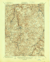
1902 Map of Patton
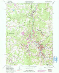
USGS Topo · Published 1955About this map
Patton sits at the heart of this survey of the Allegheny Mountains, where early 20th-century industry followed the winding course of Chest Creek. The map documents a landscape defined by its extractive economy and religious settlement patterns, with the Pennsylvania R R (Chest Creek Division) threading through narrow valleys to serve coal and timber outposts. Small communities such as St Bonifacius, St Augustine, and St Lawrence suggest the cultural roots of the area's residents, while Thomas Mills and Eckenrode Mill mark early commercial centers along the water. To the south, the terrain steepens significantly toward the crest of the mountains, noted by distinct geological breaks like Kittanning Gap and Burgoons Gap. This survey captures the region just as the Cambria and Clearfield R R established a vital link between the hilltop towns of Carrolltown and Loretto and the rail hubs of the Susquehanna valley.
Find a feature on this map
79 named features on this map. Tap any name to fly to it.
Don’t see what you’re looking for? This feature index may not catch every label — zoom into the map to look around manually.
Map Details
Editions of this 1902 Patton Map
This is the sole edition of this map. No revisions or reprints were ever made.
Historical Maps of Ebensburg Through Time
6 maps found