1960s Maps of Bradford County, Pennsylvania
Explore 25 historic maps of Bradford County from the 1960s. These maps offer a rare glimpse into what life looked like during the 1960s — showing old roads, neighborhoods, homes, and landmarks that have changed or disappeared over time.
Whether you're researching your family's past, planning a metal detecting trip, or studying how Bradford County's landscape evolved across the 1960s, these high-resolution maps are a powerful tool for exploring the history of this region.
- Focus on a specific era: All maps on this page are from the 1960s, giving you a focused view of this time period.
- See what’s changed: Compare century-old streets, trails, and buildings to today's modern landscape using overlays and satellite layers.
- Research with precision: Use these maps for genealogy, historical research, land use analysis, or educational projects.
- View, download, or print: Maps are fully viewable online in high resolution, and can be downloaded or printed for your own records.
Start exploring Bradford County's history through authentic maps from the 1960s. This is your window into the past.
Bradford County, PA maps
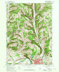
(25)- 1960 Map of Williamsport
 1960 Williamsport1960 Print · USGSNorth-central Pennsylvania in the mid-twentieth century was a vital corridor of rail and river industry stretching from the New York line to the coal regions. Genealogists can trace the rail networks of the Pennsylvania RR and Lehigh Valley RR connecting towns like Williamsport, Towanda, and Lock Haven.
 - 1962 Map of Williamsport, 1966 Print
 1962 Williamsport1966 Print · USGSNorth-central Pennsylvania was a landscape of industrial river hubs and vast state woodlands in the early sixties. Researchers can trace the path of the Pennsylvania Railroad through Williamsport and explore the remote reaches of Bucktail State Park.5 unique versions available
 - 1962 Map of Elmira, 1969 Print
 1962 Elmira1969 Print · USGSThe Finger Lakes region and Southern Tier are captured here during a period of industrial maturity and highway expansion. Researchers can trace the path of the Erie Canal, the footprint of the Seneca Army Depot, and legacy rail lines through Elmira and Ithaca.4 unique versions available
 - 1965 Map of Elmira
 1965 Elmira1965 Print · USGSThe Finger Lakes and Southern Tier regions are captured in the mid-sixties, showcasing a landscape of deep glacial valleys and heavy rail infrastructure. Trace old railroad corridors like the Pennsylvania RR or visit landmarks like Letchworth State Park and the Seneca Army Depot.
 - 1965 Map of Williamsport
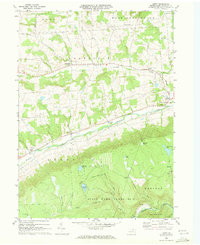
 1965 Williamsport1965 Print · USGSNorth-central Pennsylvania in the mid-1960s is defined by the industrial river towns and vast timberlands of the Allegheny Plateau. Researchers can trace historic rail lines like the Erie Lackawanna and Reading as they thread through Williamsport, Lock Haven, and Jersey Shore.
 - 1966 Map of Williamsport
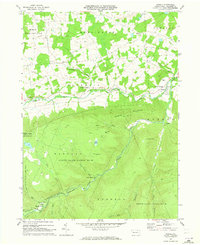
 1966 Williamsport1966 Print · USGSThe Susquehanna Valley was a hub of transit and industry in the mid-seventies, where the river's West Branch connected major college towns and timberlands. Researchers can trace historical rail lines like the Reading or locate regional landmarks from Jersey Shore to Ricketts Glen State Park.
 - 1967 Map of Towanda, 1971 Print
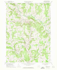
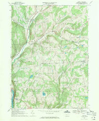
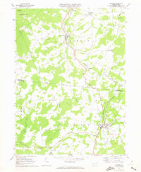
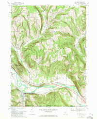
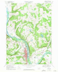 1967 Towanda1971 Print · USGSThe Susquehanna River valley and the borough of Towanda are captured in the late sixties, showing the area's transition into a modern regional hub. Researchers can trace old family sites at Sheshequin Valley Cem, the rail infrastructure of the Lehigh Valley, and landmarks like Lake Wesauking.2 unique versions available
 - 1967 Map of Windham, 1971 Print
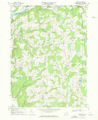
 1967 Windham1971 Print · USGSBradford County near the New York border remained a landscape of scattered creek-side settlements and upland farms in the late sixties. Genealogists and local historians can locate many rural landmarks, including the Windham Sch, Orwell Valley Cem, and Bixby Corner.2 unique versions available
 - 1967 Map of Le Raysville, 1971 Print
 1967 Le Raysville1971 Print · USGSThe rolling uplands of Bradford and Susquehanna counties come to life in this late 1960s survey. Genealogists and researchers can trace family landmarks at Stone House Corner, Centerville Cem, and the village of Le Raysville.2 unique versions available
 - 1967 Map of Little Meadows, 1971 Print
 1967 Little Meadows1971 Print · USGSUpper Susquehanna and Bradford Counties are shown in the late sixties as a network of quiet upland hamlets and creek-side farms. Genealogists can locate family landmarks like St Thomas Ch, Township Sch, and the Coburn-Dewing Cem in this rural landscape.3 unique versions available
 - 1967 Map of Rome, 1971 Print
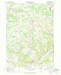
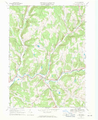
 1967 Rome1971 Print · USGSThe uplands of Bradford County are captured in the late sixties, showing the rural network of settlements and cemeteries before modern expansion. You can trace family roots through the Mercur Cem and Keene Summit Ch or follow the Lehigh Valley RR along the Susquehanna River.3 unique versions available
 - 1967 Map of Litchfield, 1971 Print
 1967 Litchfield1971 Print · USGSBradford County’s northern highlands meet the New York border in the late sixties, where upland farms and small hamlets define the landscape. Researchers can trace rural lineages through the Township Sch and local burial sites like Orange Hill Cem and Bumpville Cem.2 unique versions available
 - 1967 Map of Lawton, 1971 Print
 1967 Lawton1971 Print · USGSSusquehanna County in the late sixties reveals a network of small upland settlements and valley farms along the Wyalusing Creek. Researchers can locate historic rural burial grounds like Stedwell Cem and East Rush Cem or trace old property lines near Birchardville.3 unique versions available
 - 1969 Map of Elmira
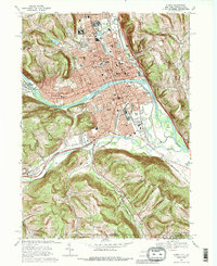 1969 Elmira1969 Print · USGSElmira and the Chemung River valley are shown at a peak of mid-century industrial and civic development. Researchers can trace family sites at Woodlawn National Cem, locate the Elmira Reformatory, or explore neighborhoods near Elmira Heights.3 unique versions available
 - 1969 Map of Waverly, 1971 Print
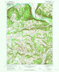
 1969 Waverly1971 Print · USGSThe river and rail corridors of the New York-Pennsylvania border are captured here in the late sixties as the village of WAVERLY thrives. Researchers can trace the legacy of the Lehigh Valley railroad or locate local landmarks like the St John of the Cross Monastery and Hicks Cem.3 unique versions available
 - 1969 Map of Seeley Creek, 1971 Print
 1969 Seeley Creek1971 Print · USGSThe Chemung River valley at the close of the sixties shows a landscape of growing residential developments and deep-rooted rural outposts. Researchers can trace family history through sites like Webb Mills, Dutch Hill Cem, and the prominent Mount Saviour Monastery.3 unique versions available
 - 1969 Map of Grover, 1972 Print
 1969 Grover1972 Print · USGSLycoming and Bradford counties are captured in the late sixties, showing a landscape shaped by narrow valleys and deep forests. Trace the Penn Central rail line through Grover or locate the remote mountain settlements of Masten, Ellenton, and Wheelerville.
 - 1969 Map of Ralston, 1972 Print
 1969 Ralston1972 Print · USGSNorthern Lycoming County was a land of timber and transit in the late sixties, where the Lycoming Creek valley funneled rail and road traffic. Genealogists can trace family lines in valley hamlets like Roaring Branch, Ralston, and Leolyn, or locate former Strip Mine operations.3 unique versions available
 - 1969 Map of Monroeton, 1973 Print
 1969 Monroeton1973 Print · USGSBradford County’s southern townships were defined by the winding valley of the Lehigh Valley railroad in the late sixties. Genealogists and local historians can locate rural burial grounds like Cole Cem and small settlements like Kellogg and Uhdey.4 unique versions available
 - 1969 Map of Colley, 1973 Print
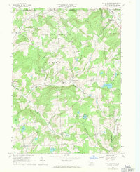
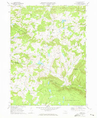 1969 Colley1973 Print · USGSThe Bradford and Sullivan County line runs through this highland territory in the late sixties, where small mountain hamlets and conservation lands define the landscape. Researchers can trace family roots through sites like St Francis Church and the crossroads at Kinsley Corners.2 unique versions available
 - 1969 Map of Dushore, 1973 Print
 1969 Dushore1973 Print · USGSThe highland communities of Sullivan and Bradford Counties are captured here in the late sixties as the mountain economy balanced timber, rail, and local industry. Researchers can locate family landmarks like Laddsburg, the Mt Tabor Cem, and the Lehigh Valley rail corridor.3 unique versions available
 - 1969 Map of Leroy, 1973 Print
 1969 Leroy1973 Print · USGSBradford County’s rural valleys and rugged highlands are captured here in the late sixties as traditional agriculture met expanding state conservation lands. Genealogists and local historians can locate family landmarks at Granville Center, West Franklin, and the old mining and lumbering sites of Barclay and Laquin.2 unique versions available
 - 1969 Map of Powell, 1973 Print
 1969 Powell1973 Print · USGSBradford County’s southern reaches are documented here in the late sixties, showing the valley communities along Towanda Creek. Local historians can trace family locations near the Monroe Franklin Sch, the Powell Cem, and the old Barclay Station.3 unique versions available
 - 1969 Map of Wyalusing, 1973 Print
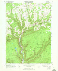
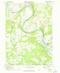 1969 Wyalusing1973 Print · USGSThe Susquehanna River dominates this Bradford County landscape in the 1960s, winding past historic riverfront settlements and railroad lines. You can trace the Lehigh Valley rail route, locate the French Asylum Ch, or explore the river crossing at Homets Ferry.
 - 1969 Map of Wellsburg, 1984 Print
 1969 Wellsburg1984 Print · USGSThe Chemung River valley in the late sixties reveals a landscape shaped by rail transport and upland farming. Genealogists can trace family names through landmarks like Wacombers Corners, the Riverside Cem, and the village of Wellsburg.
End of results
Showing maps 1-25 of 25
Top cities of Bradford County
- Sayre historical maps
- Athens historical maps
- Towanda historical maps
- Wysox Township historical maps
- Canton historical maps
- Troy historical maps
See more
Frequently asked questions
- What are the different types of historical maps available for Bradford County?
- What is the oldest map of Bradford County?
- Where can I purchase historical maps of Bradford County for my home or office?
- Where can I download high-res historical maps of Bradford County?
- Are there historical topographic maps available for Bradford County?
- Is there historical aerial imagery available for Bradford County?
- Where are historical maps of Bradford County sourced from?