1970s Maps of Bradford County, Pennsylvania
Explore 5 historic maps of Bradford County from the 1970s. These maps offer a rare glimpse into what life looked like during the 1970s — showing old roads, neighborhoods, homes, and landmarks that have changed or disappeared over time.
Whether you're researching your family's past, planning a metal detecting trip, or studying how Bradford County's landscape evolved across the 1970s, these high-resolution maps are a powerful tool for exploring the history of this region.
- Focus on a specific era: All maps on this page are from the 1970s, giving you a focused view of this time period.
- See what’s changed: Compare century-old streets, trails, and buildings to today's modern landscape using overlays and satellite layers.
- Research with precision: Use these maps for genealogy, historical research, land use analysis, or educational projects.
- View, download, or print: Maps are fully viewable online in high resolution, and can be downloaded or printed for your own records.
Start exploring Bradford County's history through authentic maps from the 1970s. This is your window into the past.
Bradford County, PA maps
(5)- 1970 Map of Gleason, 1972 Print
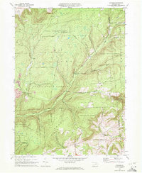 1970 Gleason1972 Print · USGSThe northern Pennsylvania highlands near the Tioga and Bradford County line are captured here in the early 1970s. Local researchers can trace family landmarks like Gleason and Allen, or locate the North Union Cem and the nearby North Union Ch.4 unique versions available
 - 1970 Map of Shunk, 1973 Print
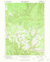 1970 Shunk1973 Print · USGSSullivan and Bradford Counties are shown here during the early 1970s, a period of quiet rural life and expanding state forest conservation. Researchers can locate remote settlements like Shunk and Minerville, or find family landmarks such as the Elkland Meetinghouse and Camp Brule.3 unique versions available
 - 1970 Map of Canton, 1973 Print
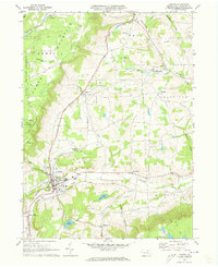 1970 Canton1973 Print · USGSBradford County’s rugged valley and rail corridor are captured here during the early seventies. Genealogists and local historians can trace the foundations of Canton and Granville Summit, or locate family sites like St Michaels Cem and the Beech Flats settlement.2 unique versions available
 - 1970 Map of Overton, 1973 Print
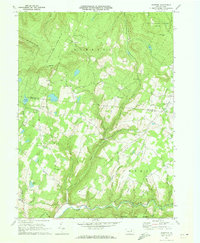 1970 Overton1973 Print · USGSSullivan and Bradford counties in the early 1970s showcase a high-elevation world of remote crossroads and upland farms. Trace family roots and local history through rural anchors like Peters Ch, the Greenwood Cem, and the village of Campbellville.2 unique versions available
 - 1977 Map of Ralston, 1979 Print
 1977 Ralston1979 Print · USGSLycoming County at the end of the 1970s reveals a landscape defined by deep valleys and upland farms. Family historians and researchers can trace the precise 1977 layout of Ralston, Roaring Branch, and the rural fields near Ogdensburg.
End of results
Showing maps 1-5 of 5
Top cities of Bradford County
- Sayre historical maps
- Athens historical maps
- Towanda historical maps
- Wysox Township historical maps
- Canton historical maps
- Troy historical maps
See more
Frequently asked questions
- What are the different types of historical maps available for Bradford County?
- What is the oldest map of Bradford County?
- Where can I purchase historical maps of Bradford County for my home or office?
- Where can I download high-res historical maps of Bradford County?
- Are there historical topographic maps available for Bradford County?
- Is there historical aerial imagery available for Bradford County?
- Where are historical maps of Bradford County sourced from?