1950s Maps of Plumstead Township, Pennsylvania
Explore 6 historic maps of Plumstead Township from the 1950s. These maps offer a rare glimpse into what life looked like during the 1950s — showing old roads, neighborhoods, homes, and landmarks that have changed or disappeared over time.
Whether you're researching your family's past, planning a metal detecting trip, or studying how Plumstead Township's landscape evolved across the 1950s, these high-resolution maps are a powerful tool for exploring the history of this region.
- Focus on a specific era: All maps on this page are from the 1950s, giving you a focused view of this time period.
- See what’s changed: Compare century-old streets, trails, and buildings to today's modern landscape using overlays and satellite layers.
- Research with precision: Use these maps for genealogy, historical research, land use analysis, or educational projects.
- View, download, or print: Maps are fully viewable online in high resolution, and can be downloaded or printed for your own records.
Start exploring Plumstead Township's history through authentic maps from the 1950s. This is your window into the past.
Plumstead Township, PA maps
(6)- 1953 Map of Buckingham, 1954 Print
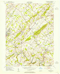 1953 Buckingham1954 Print · USGSBucks County at mid-century remains a landscape of rolling townships and rural crossroads connected by the Reading Railroad. Genealogists and local historians can trace the foundations of DOYLESTOWN and Buckingham through landmarks like the Buckingham Valley Mill, Bycot Sta, and Mt Gilead Ch.7 unique versions available
 - 1953 Map of Doylestown, 1954 Print
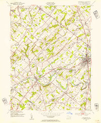 1953 Doylestown1954 Print · USGSBucks County in the early fifties shows a landscape of growing boroughs and deep-rooted rural townships. Researchers can trace ancestral locations through numerous named schoolhouses and local institutions like the National Agricultural College and Beulah Chapel.6 unique versions available
 - 1955 Map of Lumberville, 1956 Print
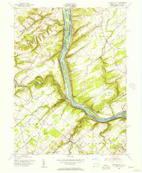 1955 Lumberville1956 Print · USGSThe Delaware River valley comes alive in the mid-1950s, showing the intricate network of the Delaware Division Canal and Pennsylvania Railroad bordering Pennsylvania and New Jersey. Genealogists can trace family footprints at Wismer PO, the Brick Church, and rural schoolhouses like Rocky Ridge Sch.6 unique versions available
 - 1956 Map of Newark
 1956 Newark1956 Print · USGSThe industrial heart of the Mid-Atlantic is captured here at the dawn of the highway era, tracing the dense corridors between Newark and Philadelphia. Genealogists and local historians can map the rail networks of the Reading RR or locate mid-century military life at Fort Dix Military Reservation.2 unique versions available
 - 1957 Map of Newark
 1957 Newark1957 Print · USGSThe industrial and military heart of the Mid-Atlantic is mapped during its post-war suburban boom. Genealogists and historians can trace the intricate rail corridors of the Reading Railroad and locate key landmarks from Princeton University to Fort Hancock.
 - 1957 Map of Bedminster, 1958 Print
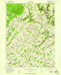 1957 Bedminster1958 Print · USGSBucks County settlements and rolling farmlands are captured here in the late fifties as rural life centered on historic crossroads. Genealogists and historians can trace family locations near the Irish Meeting House, Kellers Church, and the distinctive hamlet of Elephant.5 unique versions available
End of results
Showing maps 1-6 of 6
Top cities near Plumstead Township
- Bethlehem historical maps
- Middletown Township historical maps
- Warminster Township historical maps
- Lower Makefield Township historical maps
- Horsham Township historical maps
- Raritan Township historical maps
See more
Top neighborhoods of Plumstead Township
- Danboro historical maps
- Griers Corner historical maps
- Wismer Post Office historical maps
- Gardenville historical maps
- Dyerstown historical maps
- Plumsteadville historical maps
See more
Frequently asked questions
- What are the different types of historical maps available for Plumstead Township?
- What is the oldest map of Plumstead Township?
- Where can I purchase historical maps of Plumstead Township for my home or office?
- Where can I download high-res historical maps of Plumstead Township?
- Are there historical topographic maps available for Plumstead Township?
- Is there historical aerial imagery available for Plumstead Township?
- Where are historical maps of Plumstead Township sourced from?