1900-1909 Maps of Cambria County, Pennsylvania
Explore 9 historic maps of Cambria County from 1900-1909. These maps offer a rare glimpse into what life looked like during the 1900s — showing old roads, neighborhoods, homes, and landmarks that have changed or disappeared over time.
Whether you're researching your family's past, planning a metal detecting trip, or studying how Cambria County's landscape evolved across the 1900s, these high-resolution maps are a powerful tool for exploring the history of this region.
- Focus on a specific era: All maps on this page are from the 1900s, giving you a focused view of this time period.
- See what’s changed: Compare century-old streets, trails, and buildings to today's modern landscape using overlays and satellite layers.
- Research with precision: Use these maps for genealogy, historical research, land use analysis, or educational projects.
- View, download, or print: Maps are fully viewable online in high resolution, and can be downloaded or printed for your own records.
Start exploring Cambria County's history through authentic maps from the 1900s. This is your window into the past.
Cambria County, PA maps
(9)- 1902 Map of Ebensburg, 1954 Print
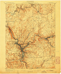
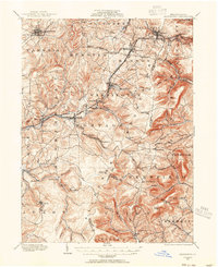 1902 Ebensburg1954 Print · USGSCambria County at the dawn of the twentieth century was a landscape of intensive rail infrastructure and mountain mining towns. Researchers can trace the Pennsylvania RR lines and find detailed footprints for settlements like Ebensburg, Cresson, and the high peak at Blue Knob.
 - 1902 Map of Patton, 1955 Print
 1902 Patton1955 Print · USGSThe northern Cambria County coal and timber country is captured here at the turn of the century, as mountain railroads reached their peak influence. Researchers can trace historic industrial sites like Eckenrode Mill and early settlements including St Bonifacius and Patton.
 - 1902 Map of Barnesboro, 1956 Print
 1902 Barnesboro1956 Print · USGSIndiana and Cambria counties are documented here at a peak of rail and coal development. Genealogists and historians can trace family roots through numerous small settlements like Possum Glory and Nicktown or follow the Pennsylvania RR through the bustling streets of Barnesboro.
 - 1904 Map of Barnesboro
 1904 Barnesboro1904 Print · USGSNorthwestern Cambria County was a hub of river and rail activity at the turn of the century, as the coal industry took hold. Genealogists can trace family names and small settlements from Barnesboro and Cherrytree to remote outposts like Strongstown and Nolo.5 unique versions available
 - 1904 Map of Patton
 1904 Patton1904 Print · USGSCambria County at the start of the century is a network of rail lines and coal settlements, anchored by the growth of Patton. Genealogists can trace family roots through historic sites like St Bonifacius, Chest Springs, and the industrial Mitchell Mines.5 unique versions available
 - 1904 Map of Ebensburg
 1904 Ebensburg1904 Print · USGSCambria County's industrial heartland is captured during the era of steam and steel, when the Pennsylvania RR crested the Allegheny Front. Genealogists and historians can trace the early layouts of Ebensburg, Lilly, and Gallitzin, or locate rural landmarks like Mt Hope Church.7 unique versions available
 - 1904 Map of Johnstown, 1954 Print
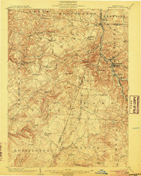
 1904 Johnstown1954 Print · USGSJohnstown and the Cambria County coalfields are shown in detail during their industrial peak in the early twentieth century. Researchers can trace ancestral neighborhoods like Morrellville and Franklin, or locate historic landmarks such as the Old Portage RR Tunnel and Grandview Cemetery.2 unique versions available
 - 1907 Map of Johnstown
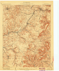
 1907 Johnstown1907 Print · USGSJohnstown and the surrounding coal valleys are captured here at the height of their industrial expansion in the early twentieth century. Researchers can trace the path of the Pennsylvania RR and find vanished local landmarks like Expedit PO and the Old Portage RR Tunnel.6 unique versions available
 - 1908 Map of Bedford, 1958 Print
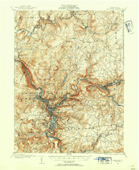
 1908 Bedford1958 Print · USGSBedford County at the turn of the century reveals a landscape of ridge-top schools and valley mill towns connected by early rail. Genealogists can trace family roots through numerous sites like Ryan Mill, Eight Square School, and Ogleton Felix PO.
End of results
Showing maps 1-9 of 9
Top cities of Cambria County
- Johnstown historical maps
- Franklin historical maps
- Westmont historical maps
- Northern Cambria historical maps
- Ebensburg historical maps
- Stonycreek Township historical maps
See more
Frequently asked questions
- What are the different types of historical maps available for Cambria County?
- What is the oldest map of Cambria County?
- Where can I purchase historical maps of Cambria County for my home or office?
- Where can I download high-res historical maps of Cambria County?
- Are there historical topographic maps available for Cambria County?
- Is there historical aerial imagery available for Cambria County?
- Where are historical maps of Cambria County sourced from?