1990s Maps of Cambria County, Pennsylvania
Explore 6 historic maps of Cambria County from the 1990s. These maps offer a rare glimpse into what life looked like during the 1990s — showing old roads, neighborhoods, homes, and landmarks that have changed or disappeared over time.
Whether you're researching your family's past, planning a metal detecting trip, or studying how Cambria County's landscape evolved across the 1990s, these high-resolution maps are a powerful tool for exploring the history of this region.
- Focus on a specific era: All maps on this page are from the 1990s, giving you a focused view of this time period.
- See what’s changed: Compare century-old streets, trails, and buildings to today's modern landscape using overlays and satellite layers.
- Research with precision: Use these maps for genealogy, historical research, land use analysis, or educational projects.
- View, download, or print: Maps are fully viewable online in high resolution, and can be downloaded or printed for your own records.
Start exploring Cambria County's history through authentic maps from the 1990s. This is your window into the past.
Cambria County, PA maps
(6)- 1993 Map of Altoona, 1998 Print
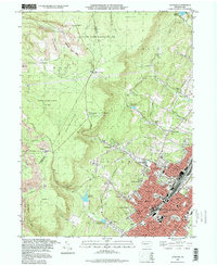 1993 Altoona1998 Print · USGSAltoona and the steep Allegheny Front are captured here in the 1990s as the city expanded its residential footprint into the surrounding hills. Genealogists and local historians can trace legacy neighborhoods and institutions like Agudath Achim Cem, Logan Sch, and Grandview Cemetery.
 - 1993 Map of Geistown, 1999 Print
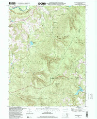
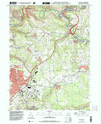 1993 Geistown1999 Print · USGSCambria County in the early nineties reveals a landscape defined by industrial history and the legacy of the Great Flood. Trace family roots at Richland Cemetery or explore landmarks like the Staple Bend Tunnel and South Fork.
 - 1998 Map of Vintondale, 1999 Print
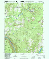 1998 Vintondale1999 Print · USGSIn the late nineties, the area around Vintondale and Wehrum remains defined by its deep mining heritage and the winding Blacklick Creek. Genealogists and historians can locate family landmarks like Memorial Ch and Delano Sch, or trace the old CONRAIL line and the Gallitzin Trail.
 - 1998 Map of Coalport, 1999 Print
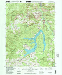 1998 Coalport1999 Print · USGSThe Clearfield and Cambria county borderlands are shown here in the late nineties, centered on the waters of Glendale Lake. Researchers can trace the legacy of local industry and transport through the Blain Run Railroad, an old railroad grade, and Coalport.
 - 1998 Map of Windber, 1999 Print
 1998 Windber1999 Print · USGSThe coal country of Somerset and Cambria counties is shown here during a period of landscape reclamation in the late nineties. Genealogists and historians can locate family landmarks like the Spaulding Sch, the Old Shade Furnace, and numerous local parishes including St Anthony Ch.
 - 1998 Map of Rachelwood, 2000 Print
 1998 Rachelwood2000 Print · USGSThe Westmoreland and Cambria county line area in the late nineties showcases a landscape of protected highlands and mountain reservoirs. Researchers can trace historic industrial sites like Baldwin Furnace and community anchors such as Legat Cem and Rachelwood.
End of results
Showing maps 1-6 of 6
Top cities of Cambria County
- Johnstown historical maps
- Franklin historical maps
- Westmont historical maps
- Northern Cambria historical maps
- Ebensburg historical maps
- Stonycreek Township historical maps
See more
Frequently asked questions
- What are the different types of historical maps available for Cambria County?
- What is the oldest map of Cambria County?
- Where can I purchase historical maps of Cambria County for my home or office?
- Where can I download high-res historical maps of Cambria County?
- Are there historical topographic maps available for Cambria County?
- Is there historical aerial imagery available for Cambria County?
- Where are historical maps of Cambria County sourced from?