1960s Maps of Ferguson Township, Pennsylvania
Explore 8 historic maps of Ferguson Township from the 1960s. These maps offer a rare glimpse into what life looked like during the 1960s — showing old roads, neighborhoods, homes, and landmarks that have changed or disappeared over time.
Whether you're researching your family's past, planning a metal detecting trip, or studying how Ferguson Township's landscape evolved across the 1960s, these high-resolution maps are a powerful tool for exploring the history of this region.
- Focus on a specific era: All maps on this page are from the 1960s, giving you a focused view of this time period.
- See what’s changed: Compare century-old streets, trails, and buildings to today's modern landscape using overlays and satellite layers.
- Research with precision: Use these maps for genealogy, historical research, land use analysis, or educational projects.
- View, download, or print: Maps are fully viewable online in high resolution, and can be downloaded or printed for your own records.
Start exploring Ferguson Township's history through authentic maps from the 1960s. This is your window into the past.
Ferguson Township, PA maps
(8)- 1961 Map of Harrisburg
 1961 Harrisburg1961 Print · USGSCentral Pennsylvania is shown at a mid-century peak of industrial and military activity, from the Susquehanna water gaps to the fertile Dutch Country. Genealogists and historians can trace the rail corridors of the Pennsylvania RR and find landmarks like Carlisle Barracks or the Anthracite Coal Fields.2 unique versions available
 - 1962 Map of State College, 1964 Print
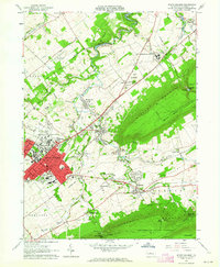 1962 State College1964 Print · USGSState College and the Penn State campus are shown in the early sixties during a period of significant collegiate and local growth. Researchers can trace historic campus buildings like Old Main or locate outlying villages such as Boalsburg and Linden Hall.5 unique versions available
 - 1962 Map of Julian, 1965 Print
 1962 Julian1965 Print · USGSCentre County centers on the growth of State College and The Pennsylvania State University in the early sixties. Researchers can find old transportation routes like the Old Railroad Grade and local landmarks including Pine Hall and the State College Air Depot.5 unique versions available
 - 1963 Map of Mc Alevys Fort, 1965 Print
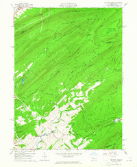 1963 Mc Alevys Fort1965 Print · USGSNorth of Huntingdon in the mid-1960s, this area shows a landscape defined by prominent ridges and early industrial sites. Researchers can trace local genealogy at McAlevys Fort or find historic locations like the Jackson-Miller Sch and Greenwood Furnace.4 unique versions available
 - 1963 Map of Franklinville, 1965 Print
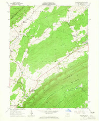 1963 Franklinville1965 Print · USGSCentral Pennsylvania’s industrial and agricultural valleys are captured here in the early sixties. Researchers can trace the heritage of Pennsylvania Furnace and locate landmark sites like Indian Caverns and Warriors Mark Airport.3 unique versions available
 - 1963 Map of Pine Grove Mills, 1965 Print
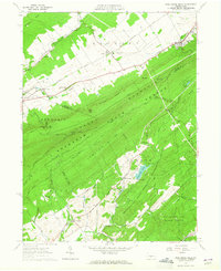 1963 Pine Grove Mills1965 Print · USGSThe ridges of central Pennsylvania define this early 1960s landscape, where university experimental forests meet historic furnace settlements. Genealogists and researchers can trace the valley communities of Pine Grove Mills and Neffs Mills or locate local landmarks like the Pennsylvania Furnace Cem and Monroe Furnace.4 unique versions available
 - 1964 Map of Pittsburgh
 1964 Pittsburgh1964 Print · USGSWestern Pennsylvania in the late fifties and early sixties shows a landscape of powerful river industries and expanding highways. Genealogists and historians can trace the rail corridors of the Pennsylvania RR through industrial hubs like Johnstown, Altoona, and Nanty Glo.
 - 1964 Map of Harrisburg
 1964 Harrisburg1964 Print · USGSCentral Pennsylvania in the mid-fifties reveals a landscape shaped by ridge-and-valley geology and critical Cold War infrastructure. Researchers can trace the massive Indiantown Gap Military Reservation or the rail corridors of the Pennsylvania RR and Reading RR.
End of results
Showing maps 1-8 of 8
Top cities near Ferguson Township
- State College historical maps
- Bellefonte historical maps
- Boalsburg historical maps
- Pleasant Gap historical maps
- Menno Township historical maps
- Houserville historical maps
See more
Top neighborhoods of Ferguson Township
- The Meadows historical maps
- Musser historical maps
- Ramblewood historical maps
- Ramblewood historical maps
- Ramblewood historical maps
- Rockspring historical maps
See more
Frequently asked questions
- What are the different types of historical maps available for Ferguson Township?
- What is the oldest map of Ferguson Township?
- Where can I purchase historical maps of Ferguson Township for my home or office?
- Where can I download high-res historical maps of Ferguson Township?
- Are there historical topographic maps available for Ferguson Township?
- Is there historical aerial imagery available for Ferguson Township?
- Where are historical maps of Ferguson Township sourced from?