1970s Maps of Old Fort, Potter Township
Explore 1 historic maps of Old Fort from the 1970s. These maps offer a rare glimpse into what life looked like during the 1970s — showing old roads, neighborhoods, homes, and landmarks that have changed or disappeared over time.
Whether you're researching your family's past, planning a metal detecting trip, or studying how Old Fort's landscape evolved across the 1970s, these high-resolution maps are a powerful tool for exploring the history of this region.
- Focus on a specific era: All maps on this page are from the 1970s, giving you a focused view of this time period.
- See what’s changed: Compare century-old streets, trails, and buildings to today's modern landscape using overlays and satellite layers.
- Research with precision: Use these maps for genealogy, historical research, land use analysis, or educational projects.
- View, download, or print: Maps are fully viewable online in high resolution, and can be downloaded or printed for your own records.
Start exploring Old Fort's history through authentic maps from the 1970s. This is your window into the past.
Old Fort, Potter Township maps
(1)- 1977 Map of Centre Hall, 1979 Print
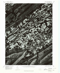 1977 Centre Hall1979 Print · USGSThe strip-cropped fields of the Penn Valley dominate the landscape in the late seventies, bordered by the steep ridges of Mount Nittany. Genealogists and local historians can trace the rural layouts of Centre Hall, Potters Mills, and the banks of Sinking Creek.
End of results
Showing maps 1-1 of 1
Top cities near Old Fort
- State College historical maps
- Lewistown historical maps
- Bellefonte historical maps
- Granville Township historical maps
- Boalsburg historical maps
- Decatur Township historical maps
See more
Frequently asked questions
- What are the different types of historical maps available for Old Fort?
- What is the oldest map of Old Fort?
- Where can I purchase historical maps of Old Fort for my home or office?
- Where can I download high-res historical maps of Old Fort?
- Are there historical topographic maps available for Old Fort?
- Is there historical aerial imagery available for Old Fort?
- Where are historical maps of Old Fort sourced from?