1940s Maps of Chester County, Pennsylvania
Explore 15 historic maps of Chester County from the 1940s. These maps offer a rare glimpse into what life looked like during the 1940s — showing old roads, neighborhoods, homes, and landmarks that have changed or disappeared over time.
Whether you're researching your family's past, planning a metal detecting trip, or studying how Chester County's landscape evolved across the 1940s, these high-resolution maps are a powerful tool for exploring the history of this region.
- Focus on a specific era: All maps on this page are from the 1940s, giving you a focused view of this time period.
- See what’s changed: Compare century-old streets, trails, and buildings to today's modern landscape using overlays and satellite layers.
- Research with precision: Use these maps for genealogy, historical research, land use analysis, or educational projects.
- View, download, or print: Maps are fully viewable online in high resolution, and can be downloaded or printed for your own records.
Start exploring Chester County's history through authentic maps from the 1940s. This is your window into the past.
Chester County, PA maps
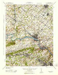
(15)- 1941 Map of Honeybrook
 1941 Honeybrook1941 Print · USGSSoutheastern Pennsylvania at the onset of the Second World War shows a landscape of established farm communities and the newly cut path of the Pennsylvania Turnpike. Researchers can locate numerous local landmarks such as Silver Hill School, Stone Church, and the rail stops along the Reading Lines.
 - 1942 Map of Norristown
 1942 Norristown1942 Print · USGSSoutheastern Pennsylvania at the onset of World War II shows a landscape of busy industrial river towns and expanding rail suburbs. Genealogists and historians can trace the early transit networks connecting Norristown, Doylestown, and the riverfront at New Hope.
 - 1942 Map of Camden
 1942 Camden1942 Print · USGSThe Philadelphia and Camden metropolitan corridor is captured here at the height of the Second World War. Genealogists and historians can trace rail networks like the Reading R.R. and locate communities from Swedesboro to Merchantville.
 - 1942 Map of Havre De Grace
 1942 Havre De Grace1942 Print · USGSThe Susquehanna riverfront and Mason-Dixon borderlands are captured here in the early 1940s, just as modern infrastructure began to reshape the region. Genealogists can trace family roots through landmarks like Smith Chapel, Lees Mill, and the Brookview Cem near Rising Sun.4 unique versions available
 - 1942 Map of Elkton
 1942 Elkton1942 Print · USGSElkton and the tristate borderlands of Maryland, Delaware, and Pennsylvania are captured here just before the mid-century expansion. Genealogists can trace family names and landmarks like Old Frenchtown Wharf, St Johns Ch, and the historic Tangent Stone.4 unique versions available
 - 1943 Map of Coatesville
 1943 Coatesville1943 Print · USGSChester County's industrial and rural landscape is shown in detail during the early 1940s, centered on the rail-driven growth of the Octoraro and Brandywine valleys. Family historians can trace ancestral roots through small hamlets and transit points like Derbydown PO, Doe Run Sta, and Sadsburyville.
 - 1943 Map of West Chester
 1943 West Chester1943 Print · USGSChester County during the early years of the war shows a landscape of established borough centers and winding creek valleys. Genealogists and historians can trace the rail-and-river network through West Chester, Brandywine Creek, and early industrial sites like Dutton Mill.
 - 1943 Map of Quarryville
 1943 Quarryville1943 Print · USGSSouthern Lancaster County is captured in detail during the early forties, showcasing a landscape of tight-knit rural townships and rail-connected villages. Genealogists can trace family footprints across numerous local sites like Nickel Mines, Conners Mill, and North Star School.
 - 1943 Map of Norristown
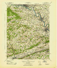
 1943 Norristown1943 Print · USGSMontgomery County in the early 1940s is a thriving network of rail-side industrial hubs and established borough centers. Genealogists and local historians can trace the development of Norristown and Lansdale or locate landmarks like the Eastern State Penitentiary.
 - 1943 Map of Phoenixville
 1943 Phoenixville1943 Print · USGSSoutheastern Pennsylvania during the early war years shows a landscape defined by the winding Schuylkill River and heavy rail traffic. Genealogists and historians can trace the early Pennsylvania Turnpike and explore historic locales like Fricks Lock and Nantmeal Village.
 - 1944 Map of Newark, 1971 Print
 1944 Newark1971 Print · USGSThe industrial corridor from Philadelphia to New York was in a period of massive transition during the mid-forties. Genealogists and researchers can trace the rail lines of the Lehigh Valley RR, locate military installations like Picatinny Arsenal, and explore the early sprawl near Levittown.5 unique versions available
 - 1945 Map of Media
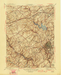 1945 Media1945 Print · USGSDelaware County is captured here in the mid-1940s, a period when traditional country estates and institutional campuses began meeting suburban expansion. Researchers can trace historic family landmarks like Tyler Arboretum, find old school sites like Sleighton Farm School, and locate the mills of Glen Riddle.2 unique versions available
 - 1946 Map of Wilmington, 1948 Print
 1946 Wilmington1948 Print · USGSThe Delaware Valley and Jersey Shore emerge in this mid-century portrait of a region defined by river commerce and seaside growth. Genealogists and historians can trace the rail networks of the Pennsylvania Railroad, locate early airfields like Dover Airpark, and find river defenses at Fort Delaware.2 unique versions available
 - 1948 Map of Baltimore
 1948 Baltimore1948 Print · USGSMaryland and Pennsylvania crossroads are captured in the late 1940s, showing a landscape defined by historic rail lines and major military installations. Genealogists can trace family connections in Gettysburg, Westminster, and near the U.S. Naval Academy in Annapolis.2 unique versions available
 - 1949 Map of Newark
 1949 Newark1949 Print · USGSThe industrial corridor between Philadelphia and New York comes alive in this post-war survey. Genealogists and historians can trace the massive rail networks of the Reading Railroad and locate major installations like Fort Dix or Picatinny Arsenal.2 unique versions available
End of results
Showing maps 1-15 of 15
Top cities of Chester County
- West Goshen Township historical maps
- West Chester historical maps
- Phoenixville historical maps
- Coatesville historical maps
- Caln Township historical maps
- New Garden Township historical maps
See more
Frequently asked questions
- What are the different types of historical maps available for Chester County?
- What is the oldest map of Chester County?
- Where can I purchase historical maps of Chester County for my home or office?
- Where can I download high-res historical maps of Chester County?
- Are there historical topographic maps available for Chester County?
- Is there historical aerial imagery available for Chester County?
- Where are historical maps of Chester County sourced from?