1950s Maps of Chester County, Pennsylvania
Explore 34 historic maps of Chester County from the 1950s. These maps offer a rare glimpse into what life looked like during the 1950s — showing old roads, neighborhoods, homes, and landmarks that have changed or disappeared over time.
Whether you're researching your family's past, planning a metal detecting trip, or studying how Chester County's landscape evolved across the 1950s, these high-resolution maps are a powerful tool for exploring the history of this region.
- Focus on a specific era: All maps on this page are from the 1950s, giving you a focused view of this time period.
- See what’s changed: Compare century-old streets, trails, and buildings to today's modern landscape using overlays and satellite layers.
- Research with precision: Use these maps for genealogy, historical research, land use analysis, or educational projects.
- View, download, or print: Maps are fully viewable online in high resolution, and can be downloaded or printed for your own records.
Start exploring Chester County's history through authentic maps from the 1950s. This is your window into the past.
Chester County, PA maps
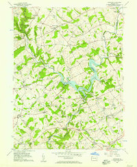
(34)- 1951 Map of Collegeville, 1953 Print
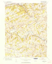
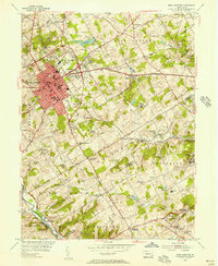
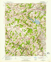
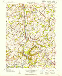 1951 Collegeville1953 Print · USGSMontgomery County was a landscape of historic institutional grounds and creek-side villages in the early fifties. Local historians can trace the footprint of Ursinus College, locate the Eastern State Penitentiary, and find old schools like Henry R Boyer Sch.2 unique versions available
 - 1952 Map of Valley Forge, 1953 Print
 1952 Valley Forge1953 Print · USGSThe Main Line and Valley Forge area are captured here during the early fifties suburban expansion. Genealogists and researchers can trace local landmarks like Washington Memorial Chapel, the School for Blind, and the Norbertine Monastery.3 unique versions available
 - 1952 Map of Norristown, 1954 Print
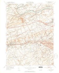
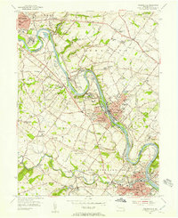
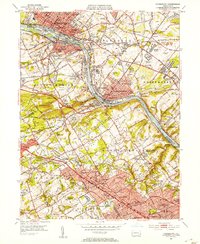 1952 Norristown1954 Print · USGSMontgomery County's river towns and Main Line colleges are captured in the early fifties during a period of rapid suburbanization. Trace the development of Villanova College and Bryn Mawr College or locate the old Patco Airport and Barbadoes Island.2 unique versions available
 - 1953 Map of Bay View, 1954 Print
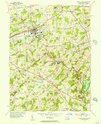
 1953 Bay View1954 Print · USGSThe Pennsylvania-Maryland border country is captured here in the early 1950s, showing the rural communities split by the Mason and Dixon Line. Researchers can locate several community hubs, including the Union Sch, Boulden Chapel, and the Pleasant Hill Lookout Tower.8 unique versions available
 - 1953 Map of Unionville, 1954 Print
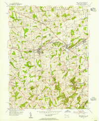
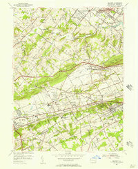
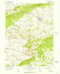
 1953 Unionville1954 Print · USGSChester County's rural character remains prominent in the early fifties, where the winding East Branch Brandywine Creek meets historic villages. Researchers can trace family sites near Saverys Mill, find the Embreeville State Hospital, and locate old schoolhouses like Copeland Sch.4 unique versions available
 - 1953 Map of Conowingo Dam, 1954 Print
 1953 Conowingo Dam1954 Print · USGSThe Cecil and Harford County borderlands are caught in a period of industrial transition during the 1950s. Genealogists and researchers can trace family landmarks like Darlington Cem, old schools at New Valley Sch, and the rail lines serving Conowingo Sta.6 unique versions available
 - 1953 Map of Newark West, 1954 Print
 1953 Newark West1954 Print · USGSThe tristate borderlands of Maryland, Pennsylvania, and Delaware appear here in the early fifties as the University of Delaware and Newark began their modern expansion. Local historians can trace the Mason and Dixon Line across the landscape, past historic sites like Welsh Tract Ch Cem and Elk Mills.6 unique versions available
 - 1953 Map of Rising Sun, 1954 Print
 1953 Rising Sun1954 Print · USGSNorthern Cecil County comes to life in the early fifties, following the historic Mason and Dixon Line into Pennsylvania. Genealogists can trace family names at West Nottingham Cem, Richards Oak, and the Brookview Chapel.6 unique versions available
 - 1953 Map of West Grove, 1955 Print
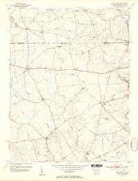
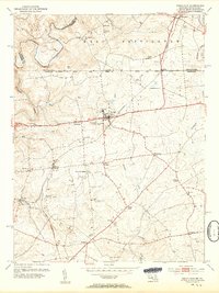
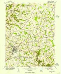
 1953 West Grove1955 Print · USGSSouthern Chester County thrived as a rail and agricultural hub in the early fifties, where the Pennsylvania railroad linked growing boroughs. Researchers can trace historic local institutions like the New London Academy, St Marys Cem, and the rural Maple Grove Sch.5 unique versions available
 - 1953 Map of Oxford, 1955 Print
 1953 Oxford1955 Print · USGSChester County's rural townships and academic centers are captured here in the early fifties. Researchers can locate numerous family-named landmarks and institutions like Lincoln University, Faggs Manor, and the Chestnut Grove Sch.4 unique versions available
 - 1953 Map of Parkesburg, 1955 Print
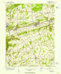 1953 Parkesburg1955 Print · USGSChester County's rail-and-valley landscape is captured here in the early fifties, showing the busy industrial corridor of the Pennsylvania Railroad. Trace old family sites near Sadsbury Meeting House or the rural crossroads of Cochranville.5 unique versions available
 - 1953 Map of Coatesville, 1956 Print
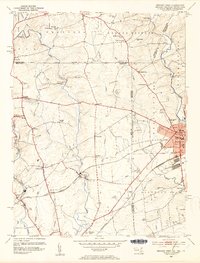
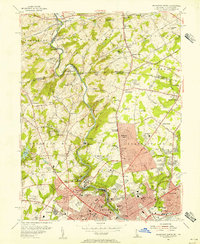
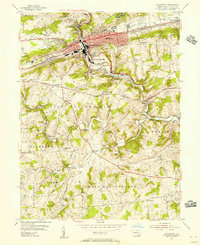 1953 Coatesville1956 Print · USGSChester County's industrial and rural crossroads are meticulously documented in the 1950s as the Lincoln Highway and major rail lines fueled the growth of Coatesville. Genealogists and local researchers can locate family-named landmarks and institutions like St Malachi Ch, the Rainbow Sch, and the U S Veterans Hospital.6 unique versions available
 - 1954 Map of Baltimore
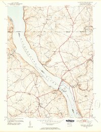
 1954 Baltimore1954 Print · USGSThe Mid-Atlantic region in the early fifties shows a landscape of growing suburban centers and heavy rail corridors. Trace mid-century transit networks and military landmarks from the Aberdeen Proving Ground to the Gettysburg National Military Park.
 - 1954 Map of West Chester, 1956 Print
 1954 West Chester1956 Print · USGSSoutheast Pennsylvania's rolling hills are captured in the mid-1950s as suburban expansion begins to blend with traditional crossroads. Genealogists can locate family landmarks such as Brinton, Green Mount Cem, and the Dante Orphanage while tracing the winding path of Chester Creek.4 unique versions available
 - 1954 Map of Kennett Square, 1956 Print
 1954 Kennett Square1956 Print · USGSThe Pennsylvania and Delaware borderlands are shown here in the mid-fifties as the region balanced its rural roots with industrial growth. Genealogists and historians can trace family locations through sites like Old Kennett Meetinghouse, Hockessin, and Yorklyn.6 unique versions available
 - 1954 Map of Wilmington North, 1956 Print
 1954 Wilmington North1956 Print · USGSNorthern Delaware and the Pennsylvania borderlands appear here in the mid-fifties, dominated by the legendary estates and facilities of the Du Pont family. Genealogists and local historians can trace the development of Fairfax and Centerville or locate landmarks like Guyencourt and the Alfred I Du Pont Institute.2 unique versions available
 - 1954 Map of Elverson, 1970 Print
 1954 Elverson1970 Print · USGSBerks and Chester counties are captured here in the mid-fifties, showing the intersection of colonial history and modern transit. Trace old family sites near Geigertown, Joanna Heights, and churches like Bethesda Ch or Ebenezer Ch.
 - 1955 Map of Wilmington
 1955 Wilmington1955 Print · USGSThe Delaware Valley and Jersey Shore are seen here during the mid-fifties era of rapid suburban expansion and highway development. You can trace the path of the New Jersey Turnpike, locate the Fort Dix Military Reservation, or explore the rail networks of the Pennsylvania Railroad.
 - 1955 Map of Media
 1955 Media1955 Print · USGSMid-century Delaware County was a landscape of significant private institutions and emerging suburbs just before the full suburban boom. Genealogists and researchers can trace local landmarks like Tyler Arboretum, the Williamson Trade School, and the historic rail junction at Wawa.2 unique versions available
 - 1955 Map of Malvern, 1957 Print
 1955 Malvern1957 Print · USGSChester County during the mid-fifties is captured here as suburban growth begins to meet established rail towns and historic valley farms. Genealogists and local historians can trace the footprint of Immaculata College, the Valley Forge Army Hospital, and early housing at General Warren Village.6 unique versions available
 - 1955 Map of Phoenixville, 1957 Print
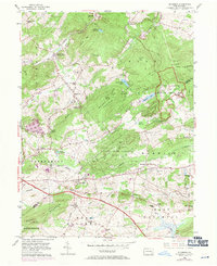
 1955 Phoenixville1957 Print · USGSPhoenixville and the surrounding townships are captured in the mid-1950s as they expanded along the winding Schuylkill River. Genealogists can trace family names through the Revolutionary Soldiers Cem, Mingo Cem, and landmarks like the Pennhurst State School.6 unique versions available
 - 1955 Map of Kirkwood, 1957 Print
 1955 Kirkwood1957 Print · USGSThe Lancaster and Chester County line comes alive in the mid-fifties, dominated by the waters of Octoraro Lake and the rural townships surrounding it. Researchers can trace ancestral locations at Colerain Cem Ch, Little Britain, and the Township Central Sch.4 unique versions available
 - 1955 Map of Honey Brook, 1957 Print
 1955 Honey Brook1957 Print · USGSChester and Lancaster counties are captured here in the mid-fifties, showing a landscape shaped by historic turnpikes and the wooded heights of Welsh Mountain. Researchers can trace old family-named landmarks and institutions like St Johns Church, Bridgeville Ch, and the Kings Highway Sch.6 unique versions available
 - 1956 Map of Baltimore
 1956 Baltimore1956 Print · USGSMid-century Maryland and Pennsylvania are captured here during a period of massive suburban and military growth across the Chesapeake region. Genealogists and historians can trace the rail corridors of the Baltimore & Ohio RR and locate landmarks like Fort McHenry or the Aberdeen Proving Ground.
 - 1956 Map of Newark
 1956 Newark1956 Print · USGSThe industrial heart of the Mid-Atlantic is captured here at the dawn of the highway era, tracing the dense corridors between Newark and Philadelphia. Genealogists and local historians can map the rail networks of the Reading RR or locate mid-century military life at Fort Dix Military Reservation.2 unique versions available
Showing maps 1-25 of 34
Top cities of Chester County
- West Goshen Township historical maps
- West Chester historical maps
- Phoenixville historical maps
- Coatesville historical maps
- Caln Township historical maps
- New Garden Township historical maps
See more
Frequently asked questions
- What are the different types of historical maps available for Chester County?
- What is the oldest map of Chester County?
- Where can I purchase historical maps of Chester County for my home or office?
- Where can I download high-res historical maps of Chester County?
- Are there historical topographic maps available for Chester County?
- Is there historical aerial imagery available for Chester County?
- Where are historical maps of Chester County sourced from?