Old Maps of West Nottingham Township, Pennsylvania for Hiking & Exploration
Hike through history with 48 historic maps of West Nottingham Township. Explore old trails, ghost towns, and forgotten backroads — perfect for outdoor adventurers and local explorers.
- Rediscover forgotten places: Map out old mining camps, roads, and footpaths that no longer exist on modern maps.
- Layer with modern tools: Combine with LiDAR or satellite views to plan hikes through historical terrain.
- Made for exploration: Popular among hikers, overlanders, and local history lovers.
Use these maps to find adventure and explore the hidden past of West Nottingham Township.
West Nottingham Township, PA maps
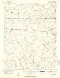
(48)- 1898 Map of Elkton
 1898 Elkton1898 Print · USGSMaryland's Upper Chesapeake shoreline and the Pennsylvania borderlands come alive in this survey of late-Victorian Cecil County. Genealogists and historians can trace the early waterfront at Elkton Landing, find the Pivot Bridge on the canal, and locate vanished rail stops at Singerly and Bacon Hill.
 - 1900 Map of Elkton
 1900 Elkton1900 Print · USGSMaryland's tidewater and rail corridors meet at the turn of the century in this detailed survey of Cecil County. Genealogists can trace family roots through old settlements like McClellandville and Singerly or locate ancestors near the Pivot Bridge.7 unique versions available
 - 1900 Map of Havre De Grace
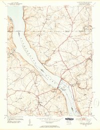
 1900 Havre De Grace1900 Print · USGSThe Susquehanna River valley at the turn of the century shows a landscape transitioning from the canal era to the railroad age. Genealogists and historians can trace defunct transport routes like the Tidewater Canal alongside active hubs like Rising Sun and Port Deposit.7 unique versions available
 - 1912 Map of Quarryville
 1912 Quarryville1912 Print · USGSLancaster County's agrarian and industrial character is frozen in time here, shortly after the 1910 survey. Researchers can trace the heavy influence of the rail network through Nickel Mines or locate rural landmarks like Wheatland Mills and Mechanic Grove.6 unique versions available
 - 1917 Map of Elkton
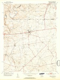
 1917 Elkton1917 Print · USGSNorthern Cecil County and the Delaware borderlands appear here in the era of rail and canal dominance. Genealogists can trace family names across Back Creek Neck or locate early settlements like Lewisville and Mechanic Valley.
 - 1942 Map of Havre De Grace
 1942 Havre De Grace1942 Print · USGSThe Susquehanna riverfront and Mason-Dixon borderlands are captured here in the early 1940s, just as modern infrastructure began to reshape the region. Genealogists can trace family roots through landmarks like Smith Chapel, Lees Mill, and the Brookview Cem near Rising Sun.4 unique versions available
 - 1942 Map of Elkton
 1942 Elkton1942 Print · USGSElkton and the tristate borderlands of Maryland, Delaware, and Pennsylvania are captured here just before the mid-century expansion. Genealogists can trace family names and landmarks like Old Frenchtown Wharf, St Johns Ch, and the historic Tangent Stone.4 unique versions available
 - 1943 Map of Quarryville
 1943 Quarryville1943 Print · USGSSouthern Lancaster County is captured in detail during the early forties, showcasing a landscape of tight-knit rural townships and rail-connected villages. Genealogists can trace family footprints across numerous local sites like Nickel Mines, Conners Mill, and North Star School.
 - 1946 Map of Wilmington, 1948 Print
 1946 Wilmington1948 Print · USGSThe Delaware Valley and Jersey Shore emerge in this mid-century portrait of a region defined by river commerce and seaside growth. Genealogists and historians can trace the rail networks of the Pennsylvania Railroad, locate early airfields like Dover Airpark, and find river defenses at Fort Delaware.2 unique versions available
 - 1948 Map of Baltimore
 1948 Baltimore1948 Print · USGSMaryland and Pennsylvania crossroads are captured in the late 1940s, showing a landscape defined by historic rail lines and major military installations. Genealogists can trace family connections in Gettysburg, Westminster, and near the U.S. Naval Academy in Annapolis.2 unique versions available
 - 1953 Map of Bay View, 1954 Print
 1953 Bay View1954 Print · USGSThe Pennsylvania-Maryland border country is captured here in the early 1950s, showing the rural communities split by the Mason and Dixon Line. Researchers can locate several community hubs, including the Union Sch, Boulden Chapel, and the Pleasant Hill Lookout Tower.8 unique versions available
 - 1953 Map of Conowingo Dam, 1954 Print
 1953 Conowingo Dam1954 Print · USGSThe Cecil and Harford County borderlands are caught in a period of industrial transition during the 1950s. Genealogists and researchers can trace family landmarks like Darlington Cem, old schools at New Valley Sch, and the rail lines serving Conowingo Sta.6 unique versions available
 - 1953 Map of Rising Sun, 1954 Print
 1953 Rising Sun1954 Print · USGSNorthern Cecil County comes to life in the early fifties, following the historic Mason and Dixon Line into Pennsylvania. Genealogists can trace family names at West Nottingham Cem, Richards Oak, and the Brookview Chapel.6 unique versions available
 - 1954 Map of Baltimore
 1954 Baltimore1954 Print · USGSThe Mid-Atlantic region in the early fifties shows a landscape of growing suburban centers and heavy rail corridors. Trace mid-century transit networks and military landmarks from the Aberdeen Proving Ground to the Gettysburg National Military Park.
 - 1955 Map of Wilmington
 1955 Wilmington1955 Print · USGSThe Delaware Valley and Jersey Shore are seen here during the mid-fifties era of rapid suburban expansion and highway development. You can trace the path of the New Jersey Turnpike, locate the Fort Dix Military Reservation, or explore the rail networks of the Pennsylvania Railroad.
 - 1955 Map of Kirkwood, 1957 Print
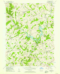 1955 Kirkwood1957 Print · USGSThe Lancaster and Chester County line comes alive in the mid-fifties, dominated by the waters of Octoraro Lake and the rural townships surrounding it. Researchers can trace ancestral locations at Colerain Cem Ch, Little Britain, and the Township Central Sch.4 unique versions available
 - 1956 Map of Baltimore
 1956 Baltimore1956 Print · USGSMid-century Maryland and Pennsylvania are captured here during a period of massive suburban and military growth across the Chesapeake region. Genealogists and historians can trace the rail corridors of the Baltimore & Ohio RR and locate landmarks like Fort McHenry or the Aberdeen Proving Ground.
 - 1957 Map of Wilmington
 1957 Wilmington1957 Print · USGSThe mid-Atlantic coastal plain comes alive in the mid-fifties as the New Jersey Turnpike and Garden State Parkway redefine travel. Researchers can trace the rail-to-road transition and find landmarks like Ship John Shoal Light and the Fort Dix Military Reservation.2 unique versions available
 - 1957 Map of Baltimore, 1964 Print
 1957 Baltimore1964 Print · USGSMaryland and Southern Pennsylvania are shown during the mid-century expansion of the Baltimore-Washington corridor. Researchers can trace the extensive rail lines of the Baltimore & Ohio RR and locate sites like Fort Detrick and Gettysburg National Military Park.5 unique versions available
 - 1959 Map of Wilmington
 1959 Wilmington1959 Print · USGSThe Delaware Valley and Jersey Shore are seen here in the late fifties, during a period of massive suburban and highway expansion. Researchers can trace mid-century infrastructure like the N J Turnpike or locate coastal landmarks from Barnegat Bay to the Maurice River.3 unique versions available
 - 1961 Map of Baltimore
 1961 Baltimore1961 Print · USGSMaryland and Pennsylvania are captured at a mid-century peak of industrial and military expansion. Genealogists and historians can trace rail corridors like the Western Maryland Ry or locate regional landmarks such as Camp Detrick and Kent Island.
 - 1966 Map of Wilmington, 1968 Print
 1966 Wilmington1968 Print · USGSThe Delaware Valley and Jersey Shore are seen here in the mid-1960s, documenting a landscape of dense industrial cities and emerging coastal resorts. Researchers can trace the sprawling rail networks of the Pennsylvania Railroad or locate landmarks like Fort Dix Military Reservation and Elk Neck State Park.4 unique versions available
 - 1972 Map of Wilmington, 1976 Print
 1972 Wilmington1976 Print · USGSThe Delaware Valley and Jersey Shore are seen here in the 1970s, showcasing the region's dense transport networks and vast state forests. Trace early coastal development near Atlantic City or locate rural landmarks like Mount Holly and Dover Air Force Base.2 unique versions available
 - 1983 Map of York, 1984 Print
 1983 York1984 Print · USGSSouth Central Pennsylvania and Northern Maryland meet along the Susquehanna during the early eighties. Genealogists and local historians can trace the transit networks of Conrail and Amtrak through towns like Red Lion and Seven Valleys.2 unique versions available
 - 1984 Map of Wilmington, 1986 Print
 1984 Wilmington1986 Print · USGSThe Delaware Valley in the mid-eighties was a powerhouse of transit and industry where Delaware, New Jersey, Pennsylvania, and Maryland meet. Researchers can trace the sprawling rail networks of SEPTA and PATCO or locate historic sites like Fort Delaware State Park and Valley Forge State Forest.2 unique versions available
Showing maps 1-25 of 48
Top cities near West Nottingham Township
- Elkton historical maps
- West Lampeter Township historical maps
- Aberdeen historical maps
- Havre de Grace historical maps
- Willow Street historical maps
- New London Township historical maps
See more
Top neighborhoods of West Nottingham Township
Frequently asked questions
- What are the different types of historical maps available for West Nottingham Township?
- What is the oldest map of West Nottingham Township?
- Where can I purchase historical maps of West Nottingham Township for my home or office?
- Where can I download high-res historical maps of West Nottingham Township?
- Are there historical topographic maps available for West Nottingham Township?
- Is there historical aerial imagery available for West Nottingham Township?
- Where are historical maps of West Nottingham Township sourced from?