1920s Maps of Pine Township, Pennsylvania
Explore 2 historic maps of Pine Township from the 1920s. These maps offer a rare glimpse into what life looked like during the 1920s — showing old roads, neighborhoods, homes, and landmarks that have changed or disappeared over time.
Whether you're researching your family's past, planning a metal detecting trip, or studying how Pine Township's landscape evolved across the 1920s, these high-resolution maps are a powerful tool for exploring the history of this region.
- Focus on a specific era: All maps on this page are from the 1920s, giving you a focused view of this time period.
- See what’s changed: Compare century-old streets, trails, and buildings to today's modern landscape using overlays and satellite layers.
- Research with precision: Use these maps for genealogy, historical research, land use analysis, or educational projects.
- View, download, or print: Maps are fully viewable online in high resolution, and can be downloaded or printed for your own records.
Start exploring Pine Township's history through authentic maps from the 1920s. This is your window into the past.
Pine Township, PA maps
(2)- 1929 Map of Clearfield
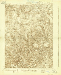 1929 Clearfield1929 Print · USGSThe riverfront and rail lines of central Pennsylvania come alive in this late 1920s survey of the West Branch Susquehanna River valley. Genealogists and historians can trace the foundations of local society through landmarks like the Leonard Waterford Sch and the rural crossroads of LeContes Mills.2 unique versions available
 - 1929 Map of Penfield, 1954 Print
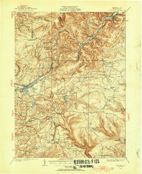 1929 Penfield1954 Print · USGSCentral Pennsylvania's rugged plateau and coal regions are mapped here in the late twenties, showing the intersection of major rail lines and isolated mountain communities. Genealogists can locate family landmarks like the Hoover Farm and several vanished rural schoolhouses including Hickory Sch and Laborde Sch.3 unique versions available
End of results
Showing maps 1-2 of 2
Top cities near Pine Township
- Sandy Township historical maps
- DuBois historical maps
- Clearfield historical maps
- Curwensville historical maps
- Goshen Township historical maps
- Grampian historical maps
See more
Top neighborhoods of Pine Township
Frequently asked questions
- What are the different types of historical maps available for Pine Township?
- What is the oldest map of Pine Township?
- Where can I purchase historical maps of Pine Township for my home or office?
- Where can I download high-res historical maps of Pine Township?
- Are there historical topographic maps available for Pine Township?
- Is there historical aerial imagery available for Pine Township?
- Where are historical maps of Pine Township sourced from?