1950s Maps of Pine Township, Pennsylvania
Explore 7 historic maps of Pine Township from the 1950s. These maps offer a rare glimpse into what life looked like during the 1950s — showing old roads, neighborhoods, homes, and landmarks that have changed or disappeared over time.
Whether you're researching your family's past, planning a metal detecting trip, or studying how Pine Township's landscape evolved across the 1950s, these high-resolution maps are a powerful tool for exploring the history of this region.
- Focus on a specific era: All maps on this page are from the 1950s, giving you a focused view of this time period.
- See what’s changed: Compare century-old streets, trails, and buildings to today's modern landscape using overlays and satellite layers.
- Research with precision: Use these maps for genealogy, historical research, land use analysis, or educational projects.
- View, download, or print: Maps are fully viewable online in high resolution, and can be downloaded or printed for your own records.
Start exploring Pine Township's history through authentic maps from the 1950s. This is your window into the past.
Pine Township, PA maps
(7)- 1957 Map of Warren, 1964 Print
 1957 Warren1964 Print · USGSThe northern Pennsylvania oil and timber country comes into focus in the mid-fifties, showing the region before modern highway expansions. Trace the industrial rail networks of the Pennsylvania RR and the early Allegheny River Reservoir near Warren and Oil City.4 unique versions available
 - 1958 Map of Warren
 1958 Warren1958 Print · USGSNorthern Pennsylvania’s timber and oil country is captured here during the late fifties, showing the interplay of industrial valleys and vast state forests. Genealogists can trace family connections across the Cornplanter Indian Reservation or through rail hubs like Oil City and Saint Marys.
 - 1959 Map of Warren
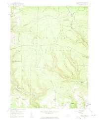
 1959 Warren1959 Print · USGSNorthern Pennsylvania's oil and timber country comes alive in this late-fifties study of the forest-clad plateaus. Trace the historic Cornplanter (Indian Reservation), the sprawling Oil Field, and the rail lines of the Pennsylvania RR.2 unique versions available
 - 1959 Map of Elliott Park, 1960 Print
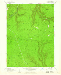
 1959 Elliott Park1960 Print · USGSThe Clearfield County high country is documented here in the late fifties as coal extraction and reforestation shaped the landscape. Genealogists and historians can trace family locations near Greenville, Pleasant Grove Ch, and numerous Strip Mines.5 unique versions available
 - 1959 Map of Huntley, 1960 Print
 1959 Huntley1960 Print · USGSThe high woods of Clearfield and Elk counties are captured here at the end of the 1950s, showing a land balanced between resource extraction and recreation. Researchers can trace early energy development at various Gas Well sites or locate landmarks like Panther Rocks and Parker Dam State Park.3 unique versions available
 - 1959 Map of Penfield, 1960 Print
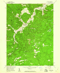 1959 Penfield1960 Print · USGSClearfield County is shown at a mid-century peak of resource extraction and forestry during the late 1950s. Genealogists and historians can trace rail-side settlements like Penfield and Winterburn, or locate family sites near the Mt Pleasant Cem and Laurel Run Cem.5 unique versions available
 - 1959 Map of Clearfield, 1961 Print
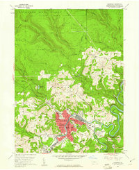 1959 Clearfield1961 Print · USGSClearfield and the Susquehanna River valley are captured here at a peak of industrial activity in the late fifties. Genealogists and historians can trace family-named sites like the Baney Settlement or locate records at Hillcrest Cem and St Francis Sch.5 unique versions available
End of results
Showing maps 1-7 of 7
Top cities near Pine Township
- Sandy Township historical maps
- DuBois historical maps
- Clearfield historical maps
- Curwensville historical maps
- Goshen Township historical maps
- Grampian historical maps
See more
Top neighborhoods of Pine Township
Frequently asked questions
- What are the different types of historical maps available for Pine Township?
- What is the oldest map of Pine Township?
- Where can I purchase historical maps of Pine Township for my home or office?
- Where can I download high-res historical maps of Pine Township?
- Are there historical topographic maps available for Pine Township?
- Is there historical aerial imagery available for Pine Township?
- Where are historical maps of Pine Township sourced from?