Old Maps of East Keating Township, Pennsylvania for Academic Research
Study the evolution of East Keating Township with 51 high-resolution historic maps. Whether you're teaching, researching, or modeling changes in land use, these maps provide essential visual documentation of urban, environmental, and geographic change.
- Analyze long-term change: Track patterns in development, transportation, and natural features.
- Ideal for environmental or urban studies: Support academic projects with primary historical map data.
- Use in the classroom or lab: Educators and researchers rely on these maps to bring historical context to life.
These maps are a powerful tool for teaching, research, and visualizing how East Keating Township has changed over the decades.
East Keating Township, PA maps
(51)- 1928 Map of Snow Shoe
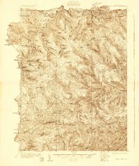 1928 Snow Shoe1928 Print · USGSCentre County's coal and timber country is documented here in the late 1920s, showing the intersection of heavy industry and wilderness. Researchers can locate active operations like Mine No 25, the village of Gillintown, and the remote Soldiers Home Camp.5 unique versions available
 - 1929 Map of Karthaus
 1929 Karthaus1929 Print · USGSThe West Branch Susquehanna River and its steep hollows defined life in Clearfield County during the late twenties. Researchers can trace the riverfront New York Central Railroad and find dozens of rural school sites like Fairview Sch and the community at Frenchville.3 unique versions available
 - 1931 Map of Show Shoe
 1931 Show Shoe1931 Print · USGSThe Pennsylvania coalfields and river valleys are captured here in the early 1930s, showing a rugged landscape defined by mountain camps and mining towns. Genealogists can trace family roots through industrial settlements like Clarence and Snow Shoe or locate old schools such as Cherry Run Sch.3 unique versions available
 - 1932 Map of Karthaus
 1932 Karthaus1932 Print · USGSThe Susquehanna’s West Branch winds through Clearfield and Centre Counties in the late 1920s, a landscape shaped by the rail and timber industries. Genealogists can trace family names through dozens of rural schools and churches like Mignot Sch and Fairview Ch.3 unique versions available
 - 1945 Map of Driftwood, 1953 Print
 1945 Driftwood1953 Print · USGSCameron County communities thrive along the river bends and rail lines at the end of World War II. Researchers can trace the dual rail paths of the Pennsylvania and Baltimore and Ohio railroads through Driftwood and locate the First Fork Sch.4 unique versions available
 - 1945 Map of Sinnemahoning, 1954 Print
 1945 Sinnemahoning1954 Print · USGSSinnemahoning and the surrounding river valleys are captured here at the height of the steam-to-diesel rail transition. Historians can trace the competing paths of the Pennsylvania and Baltimore and Ohio railroads through Jericho and past Miller Cem.5 unique versions available
 - 1946 Map of Renovo West, 1953 Print
 1946 Renovo West1953 Print · USGSClinton County's river valleys and ridgelines come alive in this mid-century survey of the Pennsylvania wilds. Trace the industrial footprint of the Pennsylvania RR through Renovo or find family history at Laurel Hill Cem and Summerson Cem.9 unique versions available
 - 1946 Map of Hammersley Fork, 1954 Print
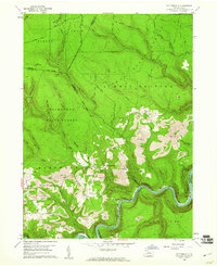
 1946 Hammersley Fork1954 Print · USGSThe deep valleys of north-central Pennsylvania appear just after the war as small creek-side settlements remain the primary nodes of local life. Genealogists can trace family names at Summerson Cem and McCoy Cem or locate the old Central Sch near Hammersley Fork.4 unique versions available
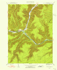
 - 1946 Map of Keating, 1954 Print
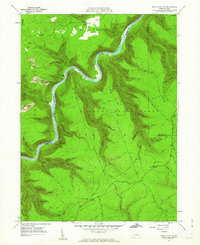
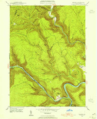 1946 Keating1954 Print · USGSClinton County’s deep river valleys and high ridges are shown just after the war, centered on the strategic rail junction at Keating. Genealogists and industrial historians can trace the New York Central line through the mountains and locate the settlement at Bitumen.4 unique versions available
 - 1947 Map of Sinnemahoning
 1947 Sinnemahoning1947 Print · USGSCameron and Clinton counties are depicted in the mid-1940s at a time when the railroad and river defined local life. Genealogists and historians can trace family locations near Sinnemahoning, Driftwood, and Miller Cem, or follow the Baltimore and Ohio line.2 unique versions available
 - 1948 Map of Keating
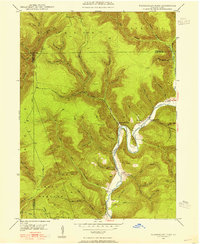
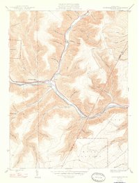
 1948 Keating1948 Print · USGSThe confluence of the Susquehanna and Sinnemahoning Creek appears in the late 1940s as a vital railroad corridor through the mountains. Genealogists and historians can trace the riverside rail stops at Keating and Wistar or the upland community of Bitumen.
 - 1948 Map of Hammersley Fork
 1948 Hammersley Fork1948 Print · USGSClinton and Potter counties appear here in the late 1940s, highlighting the rural communities nestled along the winding waters of Kettle Creek. Genealogists can locate family landmarks such as Summerson Cem, McCoy Cem, and the Central Sch.2 unique versions available
 - 1954 Map of Williamsport
 1954 Williamsport1954 Print · USGSNorth-central Pennsylvania in the mid-fifties is defined by the winding West Branch Susquehanna River and its industrial valley. Local historians can trace the massive Susquehanna Ordnance Depot and the extensive rail networks of the Pennsylvania Railroad.
 - 1957 Map of Warren, 1964 Print
 1957 Warren1964 Print · USGSThe northern Pennsylvania oil and timber country comes into focus in the mid-fifties, showing the region before modern highway expansions. Trace the industrial rail networks of the Pennsylvania RR and the early Allegheny River Reservoir near Warren and Oil City.4 unique versions available
 - 1958 Map of Warren
 1958 Warren1958 Print · USGSNorthern Pennsylvania’s timber and oil country is captured here during the late fifties, showing the interplay of industrial valleys and vast state forests. Genealogists can trace family connections across the Cornplanter Indian Reservation or through rail hubs like Oil City and Saint Marys.
 - 1959 Map of Warren
 1959 Warren1959 Print · USGSNorthern Pennsylvania's oil and timber country comes alive in this late-fifties study of the forest-clad plateaus. Trace the historic Cornplanter (Indian Reservation), the sprawling Oil Field, and the rail lines of the Pennsylvania RR.2 unique versions available
 - 1959 Map of Pottersdale, 1961 Print
 1959 Pottersdale1961 Print · USGSThe northern Pennsylvania coal and timber country is captured here during the late fifties, showing the industrial interface between state forests and coal extraction. Genealogists and historians can locate Oak Hill Ch, trace the New York Central along the river, and find rural settlements like Pottersdale and Belford.4 unique versions available
 - 1960 Map of Williamsport
 1960 Williamsport1960 Print · USGSNorth-central Pennsylvania in the mid-twentieth century was a vital corridor of rail and river industry stretching from the New York line to the coal regions. Genealogists can trace the rail networks of the Pennsylvania RR and Lehigh Valley RR connecting towns like Williamsport, Towanda, and Lock Haven.
 - 1960 Map of Snow Shoe NW, 1962 Print
 1960 Snow Shoe NW1962 Print · USGSThe West Branch of the Susquehanna winds through the high ridges of the Sproul State Forest at the start of the sixties. Genealogists and forest historians can trace the New York Central rail line, Nelson Cem, and the Panther Fire Tower.5 unique versions available
 - 1962 Map of Williamsport, 1966 Print
 1962 Williamsport1966 Print · USGSNorth-central Pennsylvania was a landscape of industrial river hubs and vast state woodlands in the early sixties. Researchers can trace the path of the Pennsylvania Railroad through Williamsport and explore the remote reaches of Bucktail State Park.5 unique versions available
 - 1965 Map of Williamsport
 1965 Williamsport1965 Print · USGSNorth-central Pennsylvania in the mid-1960s is defined by the industrial river towns and vast timberlands of the Allegheny Plateau. Researchers can trace historic rail lines like the Erie Lackawanna and Reading as they thread through Williamsport, Lock Haven, and Jersey Shore.
 - 1966 Map of Williamsport
 1966 Williamsport1966 Print · USGSThe Susquehanna Valley was a hub of transit and industry in the mid-seventies, where the river's West Branch connected major college towns and timberlands. Researchers can trace historical rail lines like the Reading or locate regional landmarks from Jersey Shore to Ricketts Glen State Park.
 - 1971 Map of Warren
 1971 Warren1971 Print · USGSNorth Central Pennsylvania is captured here in the early seventies, showing a landscape defined by industrial centers and massive state forests. Genealogists and historians can trace the rail lines of the Penn Central and Erie Lackawanna connecting towns like Warren, Kane, and Du Bois.
 - 1983 Map of Clearfield, 1984 Print
 1983 Clearfield1984 Print · USGSPennsylvania's coal and timber heartland is captured in the early eighties as industrial hubs like Du Bois and Saint Marys thrived among the state forests. Genealogists can locate family landmarks like Morningside Cemetery, the old works at Dagus Mines, and the rural community of Byrnedale.
 - 1984 Map of Williamsport West, 1985 Print
 1984 Williamsport West1985 Print · USGSCentral Pennsylvania in the mid-eighties was a landscape of dense state forests and industrious river towns along the West Branch Susquehanna River. Trace the rail lines of Conrail through Renovo or locate the historic grounds of Lock Haven State College.2 unique versions available
Showing maps 1-25 of 51
Top cities near East Keating Township
- Karthaus Township historical maps
- Leidy Township historical maps
- Wharton Township historical maps
- Driftwood historical maps
Top neighborhoods of East Keating Township
Frequently asked questions
- What are the different types of historical maps available for East Keating Township?
- What is the oldest map of East Keating Township?
- Where can I purchase historical maps of East Keating Township for my home or office?
- Where can I download high-res historical maps of East Keating Township?
- Are there historical topographic maps available for East Keating Township?
- Is there historical aerial imagery available for East Keating Township?
- Where are historical maps of East Keating Township sourced from?