1940s Maps of Hammersley Fork, Leidy Township
Explore 3 historic maps of Hammersley Fork from the 1940s. These maps offer a rare glimpse into what life looked like during the 1940s — showing old roads, neighborhoods, homes, and landmarks that have changed or disappeared over time.
Whether you're researching your family's past, planning a metal detecting trip, or studying how Hammersley Fork's landscape evolved across the 1940s, these high-resolution maps are a powerful tool for exploring the history of this region.
- Focus on a specific era: All maps on this page are from the 1940s, giving you a focused view of this time period.
- See what’s changed: Compare century-old streets, trails, and buildings to today's modern landscape using overlays and satellite layers.
- Research with precision: Use these maps for genealogy, historical research, land use analysis, or educational projects.
- View, download, or print: Maps are fully viewable online in high resolution, and can be downloaded or printed for your own records.
Start exploring Hammersley Fork's history through authentic maps from the 1940s. This is your window into the past.
Hammersley Fork, Leidy Township maps
(3)- 1946 Map of Renovo West, 1953 Print
 1946 Renovo West1953 Print · USGSClinton County's river valleys and ridgelines come alive in this mid-century survey of the Pennsylvania wilds. Trace the industrial footprint of the Pennsylvania RR through Renovo or find family history at Laurel Hill Cem and Summerson Cem.9 unique versions available
 - 1946 Map of Hammersley Fork, 1954 Print
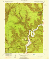 1946 Hammersley Fork1954 Print · USGSThe deep valleys of north-central Pennsylvania appear just after the war as small creek-side settlements remain the primary nodes of local life. Genealogists can trace family names at Summerson Cem and McCoy Cem or locate the old Central Sch near Hammersley Fork.4 unique versions available
 - 1948 Map of Hammersley Fork
 1948 Hammersley Fork1948 Print · USGSClinton and Potter counties appear here in the late 1940s, highlighting the rural communities nestled along the winding waters of Kettle Creek. Genealogists can locate family landmarks such as Summerson Cem, McCoy Cem, and the Central Sch.2 unique versions available
End of results
Showing maps 1-3 of 3
Top cities near Hammersley Fork
- Karthaus Township historical maps
- Austin historical maps
- South Renovo historical maps
- Leidy Township historical maps
- Abbott Township historical maps
- Wharton Township historical maps
See more
Frequently asked questions
- What are the different types of historical maps available for Hammersley Fork?
- What is the oldest map of Hammersley Fork?
- Where can I purchase historical maps of Hammersley Fork for my home or office?
- Where can I download high-res historical maps of Hammersley Fork?
- Are there historical topographic maps available for Hammersley Fork?
- Is there historical aerial imagery available for Hammersley Fork?
- Where are historical maps of Hammersley Fork sourced from?