1950s Maps of Hampden Township, Pennsylvania
Explore 8 historic maps of Hampden Township from the 1950s. These maps offer a rare glimpse into what life looked like during the 1950s — showing old roads, neighborhoods, homes, and landmarks that have changed or disappeared over time.
Whether you're researching your family's past, planning a metal detecting trip, or studying how Hampden Township's landscape evolved across the 1950s, these high-resolution maps are a powerful tool for exploring the history of this region.
- Focus on a specific era: All maps on this page are from the 1950s, giving you a focused view of this time period.
- See what’s changed: Compare century-old streets, trails, and buildings to today's modern landscape using overlays and satellite layers.
- Research with precision: Use these maps for genealogy, historical research, land use analysis, or educational projects.
- View, download, or print: Maps are fully viewable online in high resolution, and can be downloaded or printed for your own records.
Start exploring Hampden Township's history through authentic maps from the 1950s. This is your window into the past.
Hampden Township, PA maps
(8)- 1950 Map of Harrisburg, 1952 Print
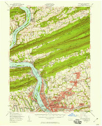
 1950 Harrisburg1952 Print · USGSMid-century Central Pennsylvania comes alive through its dense rail networks and river valley settlements during the post-war industrial era. Genealogists and historians can trace family roots through hubs like Harrisburg, locate Carlisle Barracks, or follow the Pennsylvania RR through the Lebanon Valley.
 - 1952 Map of Wertzville, 1958 Print
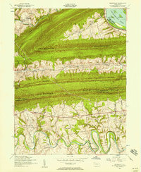 1952 Wertzville1958 Print · USGSPerry and Cumberland counties are shown here in the early 1950s, defined by the steep ridges of the Appalachians and the winding Conodoguinet Creek. Researchers can trace the mid-century landscape of Wertzville, find Hustons Mill, or follow the Appalachian Trail over Blue Mountain.4 unique versions available
 - 1952 Map of Mechanicsburg, 1958 Print
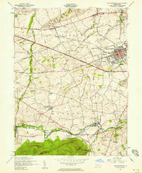 1952 Mechanicsburg1958 Print · USGSCumberland County at mid-century shows a landscape of historic crossroad villages and burgeoning military infrastructure. Trace the early routes of the Appalachian Trail and find family-named landmarks like Leidighs, Churchtown, and Hickorytown.6 unique versions available
 - 1952 Map of Carlisle, 1959 Print
 1952 Carlisle1959 Print · USGSCumberland County at the midpoint of the century shows a landscape defined by its historic military presence and the emerging Turnpike. Genealogists and hikers can trace the Appalachian Trail over Long Mountain or locate family sites at Churchtown and Deardorffs Mill.2 unique versions available
 - 1952 Map of New Bloomfield, 1959 Print
 1952 New Bloomfield1959 Print · USGSPerry County's ridge-and-valley landscape is captured here in the early 1950s, showing a region defined by river commerce and rural mountain life. Genealogists can trace family names through dozens of landmarks like Carson Long Institute, St Davids Ch, and Shermans Dale Sch.2 unique versions available
 - 1956 Map of New Cumberland, 1958 Print
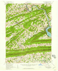
 1956 New Cumberland1958 Print · USGSMid-century development meets deep-rooted Pennsylvania history as the post-war expansion of Harrisburg reaches toward the rural townships of York County. Trace family roots and local landmarks from Eberlys Mill and the Quaker Meetinghouse Cem to the sprawling Harrisburg State Airport.3 unique versions available
 - 1956 Map of Harrisburg, 1958 Print
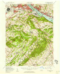
 1956 Harrisburg1958 Print · USGSThe Pennsylvania state capital and its surrounding mountain gaps are captured here in the mid-1950s as suburban expansion met the Susquehanna's industrial riverfront. Trace the path of the Stony Creek Railroad or locate family roots at Good Hope Mills and the Rutter Sch.6 unique versions available
 - 1957 Map of Harrisburg
 1957 Harrisburg1957 Print · USGSMid-century Central Pennsylvania comes into focus as a bustling network of rail, river, and mountain ridges. Genealogists and historians can trace the development of the State Capitol and surrounding hubs like Middletown, Columbia, and Pottsville.7 unique versions available
End of results
Showing maps 1-8 of 8
Top cities near Hampden Township
- Harrisburg historical maps
- Carlisle historical maps
- Colonial Park historical maps
- Progress historical maps
- New Cumberland historical maps
- Lower Allen historical maps
See more
Top neighborhoods of Hampden Township
- Peace Church historical maps
- Ridgeland historical maps
- Good Hope historical maps
- Good Hope Mill historical maps
- Oakwood Park historical maps
- Sporting Hill historical maps
See more
Frequently asked questions
- What are the different types of historical maps available for Hampden Township?
- What is the oldest map of Hampden Township?
- Where can I purchase historical maps of Hampden Township for my home or office?
- Where can I download high-res historical maps of Hampden Township?
- Are there historical topographic maps available for Hampden Township?
- Is there historical aerial imagery available for Hampden Township?
- Where are historical maps of Hampden Township sourced from?