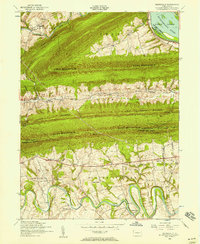
1952 Map of Wertzville
USGS Topo · Published 1958About this map
Cove Mountain and Blue Mountain dominate this landscape, creating a series of parallel valleys where small rural settlements like Wertzville and Donnellytown took root in the mid-20th century. The intricate meanders of Conodoguinet Creek in the south contrast sharply with the straight, steep ridges to the north, illustrating the geological character of the Ridge-and-Valley Appalachians.
Find a feature on this map
52 named features on this map. Tap any name to fly to it.
Don’t see what you’re looking for? This feature index may not catch every label — zoom into the map to look around manually.
Map Details
Editions of this 1952 Wertzville Map
4 editions found
Other maps of this area

1892 · Harrisburg
USGS Topo · 1:62,500

1899 · Harrisburg
USGS Topo · 1:62,500

1904 · Carlisle
USGS Topo · 1:62,500

1906 · New Cumberland
USGS Topo · 1:62,500

1907 · New Bloomfield
USGS Topo · 1:62,500

1924 · Harrisburg
USGS Topo · 1:62,500

1943 · New Cumberland
USGS Topo · 1:62,500

1943 · Harrisburg
USGS Topo · 1:62,500

1943 · New Bloomfield
USGS Topo · 1:62,500

1943 · Carlisle
USGS Topo · 1:62,500
Featured Places
- Middlesex Township, PA
- Penn Township, PA
- Dellville, Wheatfield Township
- Wertzville, Silver Spring Township
- Wheatfield Township, PA