1990s Maps of Fairview Township, Pennsylvania
Explore 2 historic maps of Fairview Township from the 1990s. These maps offer a rare glimpse into what life looked like during the 1990s — showing old roads, neighborhoods, homes, and landmarks that have changed or disappeared over time.
Whether you're researching your family's past, planning a metal detecting trip, or studying how Fairview Township's landscape evolved across the 1990s, these high-resolution maps are a powerful tool for exploring the history of this region.
- Focus on a specific era: All maps on this page are from the 1990s, giving you a focused view of this time period.
- See what’s changed: Compare century-old streets, trails, and buildings to today's modern landscape using overlays and satellite layers.
- Research with precision: Use these maps for genealogy, historical research, land use analysis, or educational projects.
- View, download, or print: Maps are fully viewable online in high resolution, and can be downloaded or printed for your own records.
Start exploring Fairview Township's history through authentic maps from the 1990s. This is your window into the past.
Fairview Township, PA maps
(2)- 1998 Map of Fairview, 1999 Print
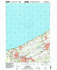 1998 Fairview1999 Print · USGSThe Lake Erie shoreline in the late nineties shows a well-established network of rail junctions and residential lakefront communities. Genealogists and historians can locate legacy institutions like the Divine Word Seminary, St Johns Cem, and Wallace Junction.
 - 1998 Map of Swanville, 1999 Print
 1998 Swanville1999 Print · USGSThe Lake Erie shoreline and the expanding suburbs of Erie are captured here in the late nineties as modern infrastructure began to reshape the landscape. Genealogists and local historians can locate Trinity Cem, Villa Maria Academy, and the early layout of Swanville.
End of results
Showing maps 1-2 of 2
Top cities near Fairview Township
- Erie historical maps
- Harborcreek Township historical maps
- Edinboro historical maps
- Lawrence Park Township historical maps
- Wesleyville historical maps
- Girard historical maps
See more
Top neighborhoods of Fairview Township
- Manchester Beach historical maps
- Sterrettania historical maps
- Avonia historical maps
- Green Acres historical maps
- Honey Tree Hollow historical maps
- The Homes of Pine Grove historical maps
See more
Frequently asked questions
- What are the different types of historical maps available for Fairview Township?
- What is the oldest map of Fairview Township?
- Where can I purchase historical maps of Fairview Township for my home or office?
- Where can I download high-res historical maps of Fairview Township?
- Are there historical topographic maps available for Fairview Township?
- Is there historical aerial imagery available for Fairview Township?
- Where are historical maps of Fairview Township sourced from?