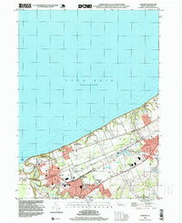
1998 Map of Fairview
USGS Topo · Published 1999About this map
Lake Erie defines the northern reaches of this Pennsylvania shoreline survey, where the waters of Elk Creek reach The Mouth near Lake City. The landscape is a corridor of transportation and institutional history, notably featuring the Divine Word Seminary and the County Infirmary. As of the late 1990s, the region's rail infrastructure remained a dominant element, with the Conrail and Norfolk And Western lines intersecting at significant transit points like Girard Junction and Wallace Junction. Settlement patterns follow the historic routes of Lake Road and Middle Road, connecting the residential hubs of Fairview and Avonia. For those researching local lineages, the map identifies key community sites including Rice Avenue Union High Sch and several burial grounds such as St Johns Cem and Fairview Cem.
Find a feature on this map
39 named features on this map. Tap any name to fly to it.
Don’t see what you’re looking for? This feature index may not catch every label — zoom into the map to look around manually.
Map Details
Editions of this 1998 Fairview Map
This is the sole edition of this map. No revisions or reprints were ever made.
Other maps of this area

1899 · Erie
USGS Topo · 1:62,500

1900 · Girard
USGS Topo · 1:62,500

1900 · Erie
USGS Topo · 1:62,500

1900 · Fairview
USGS Topo · 1:62,500

1923 · Cambridge Springs
USGS Topo · 1:62,500

1925 · Cambridge Springs
USGS Topo · 1:62,500

1943 · Cambridge Springs
USGS Topo · 1:62,500

1950 · Cleveland
USGS Topo · 1:250,000

1950 · Erie
USGS Topo · 1:250,000

1956 · Cleveland
USGS Topo · 1:250,000