Old Maps of Perry Township, Pennsylvania for Academic Research
Study the evolution of Perry Township with 25 high-resolution historic maps. Whether you're teaching, researching, or modeling changes in land use, these maps provide essential visual documentation of urban, environmental, and geographic change.
- Analyze long-term change: Track patterns in development, transportation, and natural features.
- Ideal for environmental or urban studies: Support academic projects with primary historical map data.
- Use in the classroom or lab: Educators and researchers rely on these maps to bring historical context to life.
These maps are a powerful tool for teaching, research, and visualizing how Perry Township has changed over the decades.
Perry Township, PA maps
(25)- 1902 Map of Brownsville
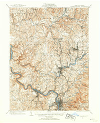
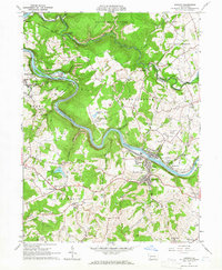
 1902 Brownsville1902 Print · USGSThe Monongahela Valley was a powerhouse of Pennsylvania industry at the start of the twentieth century, defined by its coal mines and river-front rail lines. Researchers can trace the heritage of the National Pike and locate vanished works at Vesta Mine or Coal Bluff.
 - 1902 Map of Connellsville
 1902 Connellsville1902 Print · USGSThe Pennsylvania coke region comes alive at the turn of the century as a labyrinth of coal mines and competing rail lines. Researchers can trace the industrial footprint of Star Mines, explore the river landings along the Youghiogheny River, and find old junctions like Bells Mills.5 unique versions available
 - 1906 Map of Brownsville
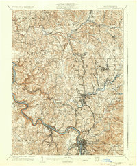
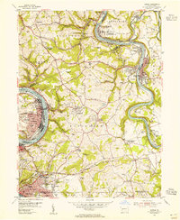
 1906 Brownsville1906 Print · USGSSouthwestern Pennsylvania’s river valleys were centers of industrial expansion when this survey was conducted. Genealogists can locate family homes and landmarks in riverfront towns like Monessen and Charleroi, or trace rural roots near Salem Church and Ginger Hill.4 unique versions available
 - 1931 Map of Brownsville, 1954 Print
 1931 Brownsville1954 Print · USGSThe industrial Monongahela and Youghiogheny river valleys are captured here in the early thirties, showcasing a landscape of coal mines and river locks. Genealogists can trace family homes near Vesta Mine, Sutersville, and rural landmarks like Salem Church.
 - 1931 Map of Connellsville, 1954 Print
 1931 Connellsville1954 Print · USGSSouthwestern Pennsylvania's coal and rail heartland is meticulously detailed here in the early thirties. Local researchers can trace the industrial footprint of Star Mines, the sprawling rail yards of Connellsville, and rural landmarks like Bryner Ch and Mud Sch.2 unique versions available
 - 1933 Map of Brownsville
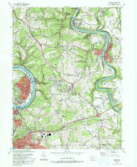
 1933 Brownsville1933 Print · USGSWestern Pennsylvania’s industrial heartland thrives along the river bends in the early thirties, where coal and rail define the landscape. Trace the expansion of river towns like Charleroi and Monessen, locate the Vesta Mine, or find rural landmarks like Mt Union Sch.2 unique versions available
 - 1936 Map of Connellsville
 1936 Connellsville1936 Print · USGSSouthwestern Pennsylvania during the mid-1930s reveals a landscape of industrial power and rural community along the Youghiogheny River. Genealogists and historians can trace family roots through numerous named schools like Jefferson Sch and Gault Sch, or locate former industrial hubs at Star Mines and the Fairgrounds.3 unique versions available
 - 1940 Map of Brownsville
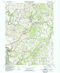
 1940 Brownsville1940 Print · USGSThe Monongahela and Youghiogheny river valleys were the industrial heart of Pennsylvania during this era of coal and steel. Genealogists and historians can trace the exact locations of Vesta Mine, Salem Church, and historic rural schools like Central Sch.
 - 1953 Map of Pittsburgh
 1953 Pittsburgh1953 Print · USGSWestern Pennsylvania's industrial landscape at the start of the fifties shows the steel and rail corridors between Pittsburgh and Altoona. Trace family roots in river towns like Tarentum or follow the Pennsylvania Turnpike across Laurel Hill.
 - 1954 Map of Pittsburgh
 1954 Pittsburgh1954 Print · USGSWestern Pennsylvania in the early fifties remains a powerhouse of heavy industry and vital transit corridors. Genealogists and historians can trace the rail-and-river network connecting Pittsburgh, Johnstown, and Altoona via the Pennsylvania RR and the Lincoln Highway.2 unique versions available
 - 1954 Map of Smithton, 1955 Print
 1954 Smithton1955 Print · USGSWestmoreland County at the height of its mid-century mining era shows a landscape of busy coal towns and river-fed industry. Genealogists can trace family roots through numerous local landmarks like St Timothys Cem, Cameron Sch, and the Hough Fricano Mine No 1 (Active).4 unique versions available
 - 1954 Map of Fayette City, 1955 Print
 1954 Fayette City1955 Print · USGSThe industrial river valleys of Fayette and Washington counties come alive in the mid-fifties. Trace family roots and coal history through Fayette City, Rowes Run, and old landmarks like Little Redstone Ch and the Colonial Dock.3 unique versions available
 - 1954 Map of Donora, 1955 Print
 1954 Donora1955 Print · USGSThe industrial heart of the Monongahela and Youghiogheny valleys is captured here during the mid-fifties. Researchers can trace coal operations at Ocean Mine and Coal Hollow Mine or locate family roots at Concord Pioneer Sch.4 unique versions available
 - 1958 Map of Pittsburgh
 1958 Pittsburgh1958 Print · USGSWestern Pennsylvania in the late fifties shows an industrial heartland defined by the confluence of the Allegheny River and Monongahela River. Researchers can trace the sprawling rail networks of the Pennsylvania RR and find established towns like Butler, Latrobe, and Windber.5 unique versions available
 - 1959 Map of Pittsburgh
 1959 Pittsburgh1959 Print · USGSWestern Pennsylvania in the late fifties is captured here at the height of its industrial era. Genealogists and historians can trace the riverfront growth of Pittsburgh, the rail works at Altoona, and the mountain gaps of Laurel Hill.
 - 1964 Map of Pittsburgh
 1964 Pittsburgh1964 Print · USGSWestern Pennsylvania in the late fifties and early sixties shows a landscape of powerful river industries and expanding highways. Genealogists and historians can trace the rail corridors of the Pennsylvania RR through industrial hubs like Johnstown, Altoona, and Nanty Glo.
 - 1964 Map of Dawson, 1965 Print
 1964 Dawson1965 Print · USGSFayette County’s industrial heart is revealed in the mid-sixties as coal and rail dominate the Youghiogheny River valley. Researchers can trace the heritage of local patch towns like Dawson, find the historic Alliance Furnace, or locate family plots at Bethel Cem.4 unique versions available
 - 1986 Map of Pittsburgh East
 1986 Pittsburgh East1986 Print · USGSWestern Pennsylvania in the mid-eighties shows a landscape defined by industrial rivers and rising mountain ridges. Trace the dense rail networks of CONRAIL and the Pittsburgh and Lake Erie RR connecting historic centers like Monessen, Jeannette, and Connellsville.3 unique versions available
 - 1993 Map of Donora
 1993 Donora1993 Print · USGSThe industrial river valleys of the Monongahela and Youghiogheny are captured in the early nineties as they balance legacy industry with growing suburbs. Genealogists can trace family roots through sites like Douglass Cem, Apples Mill Ch, and the Concord Pioneer Sch.2 unique versions available
 - 1994 Map of Smithton
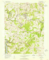
 1994 Smithton1994 Print · USGSWestmoreland County communities like Smithton and Yukon are shown at the close of the twentieth century, as regional infrastructure adapted to the Pennsylvania Turnpike. Researchers can locate family landmarks such as Seven Dolors Cem and Barren Run Sch.
 - 1997 Map of Smithton, 2000 Print
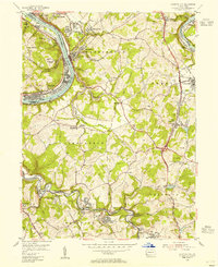
 1997 Smithton2000 Print · USGSWestmoreland County at the end of the nineties shows a landscape where the Youghiogheny River valley meets the infrastructure of the turnpike. Researchers can locate family landmarks like St Timothy Cem, the Barren Run Sch, and the borough of Smithton.
 - 2023 Map of Smithton, 2023 Print
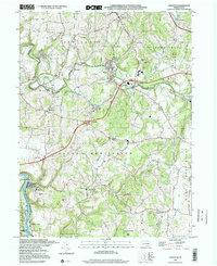
 2023 Smithton2023 Print · USGSWestmoreland County at the start of the 2020s shows a complex network of small settlements and riverfront communities along the Youghiogheny River. Genealogy researchers can trace family landmarks and rural congregations at Saint Paul Seanor Cem and Sewickley Presbyterian Church.
 - 2023 Map of Dawson, 2023 Print
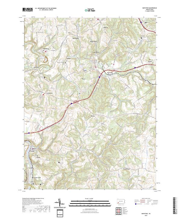
 2023 Dawson2023 Print · USGSThe Youghiogheny River corridor in Fayette County comes alive in this contemporary survey of its historic river towns and industrial roots. Researchers can trace genealogical ties at the Dickerson Family Cem or explore early industry at the Alliance Furnace and Kilndigging Hill.
 - 2023 Map of Fayette City, 2023 Print
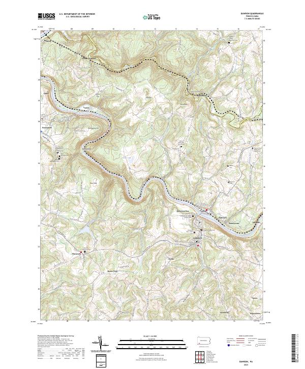
 2023 Fayette City2023 Print · USGSFayette and Washington counties meet along the Monongahela River valley during a period of modern transition. Local historians can trace numerous pioneer burial sites and family plots, including the Providence Meeting House Cem, Havely Cem, and the riverside rail corridor of the Wheeling-Pitts RR.
 - 2023 Map of Donora, 2023 Print
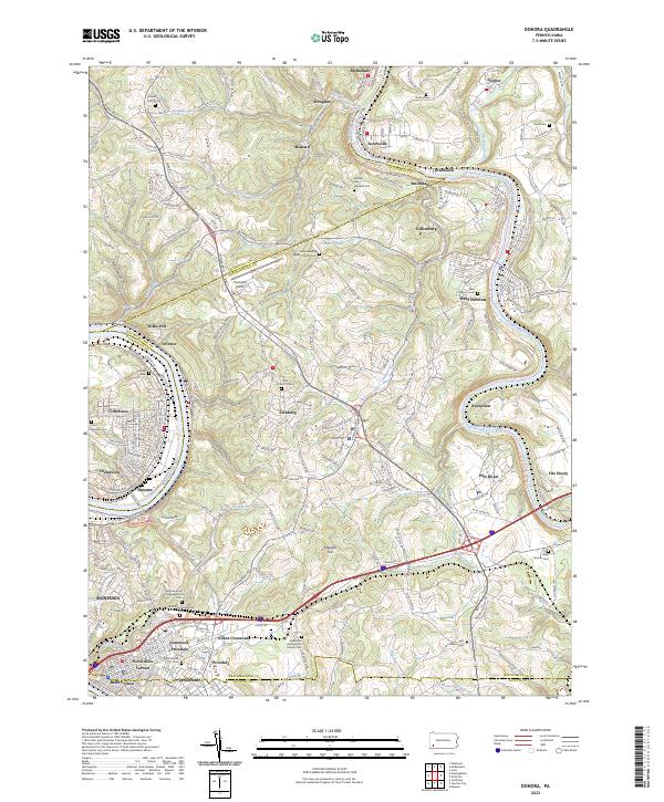 2023 Donora2023 Print · USGSThe industrial river valleys of Washington and Westmoreland counties are shown here in the early twenty-first century. Researchers can trace family sites at Round Hill Cem, the Plummer School, and many churches from Donora to West Newton.
End of results
Showing maps 1-25 of 25
Top cities near Perry Township
- Greensburg historical maps
- Uniontown historical maps
- Connellsville historical maps
- Monessen historical maps
- Clairton historical maps
- California historical maps
See more
Top neighborhoods of Perry Township
- Whitsett historical maps
- Kier historical maps
- Banning historical maps
- Star Junction historical maps
- Layton historical maps
- Wickhaven historical maps
See more
Frequently asked questions
- What are the different types of historical maps available for Perry Township?
- What is the oldest map of Perry Township?
- Where can I purchase historical maps of Perry Township for my home or office?
- Where can I download high-res historical maps of Perry Township?
- Are there historical topographic maps available for Perry Township?
- Is there historical aerial imagery available for Perry Township?
- Where are historical maps of Perry Township sourced from?