1940s Maps of Forest County, Pennsylvania
Explore 7 historic maps of Forest County from the 1940s. These maps offer a rare glimpse into what life looked like during the 1940s — showing old roads, neighborhoods, homes, and landmarks that have changed or disappeared over time.
Whether you're researching your family's past, planning a metal detecting trip, or studying how Forest County's landscape evolved across the 1940s, these high-resolution maps are a powerful tool for exploring the history of this region.
- Focus on a specific era: All maps on this page are from the 1940s, giving you a focused view of this time period.
- See what’s changed: Compare century-old streets, trails, and buildings to today's modern landscape using overlays and satellite layers.
- Research with precision: Use these maps for genealogy, historical research, land use analysis, or educational projects.
- View, download, or print: Maps are fully viewable online in high resolution, and can be downloaded or printed for your own records.
Start exploring Forest County's history through authentic maps from the 1940s. This is your window into the past.
Forest County, PA maps
(7)- 1940 Map of Hallton
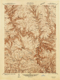 1940 Hallton1940 Print · USGSElk and Jefferson Counties appear here in the early 1940s, showing a landscape defined by the Clarion River valley and the growth of the Allegheny National Forest. Researchers can find old industrial sites and rural landmarks like the Empire Tunnel, St Tobias Cem, and the CCC Camp.3 unique versions available
 - 1941 Map of Sheffield
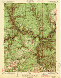
 1941 Sheffield1941 Print · USGSForest and Warren Counties are seen here during the early 1940s, a period when local logging and oil activities shaped the landscape. Researchers can trace the Tionesta Valley RR and find remote outposts like Pigeon PO or Seldom Seen Cors.2 unique versions available
 - 1941 Map of Marienville
 1941 Marienville1941 Print · USGSForest, Clarion, and Jefferson counties meet along the winding Clarion River in this pre-war survey of northern Pennsylvania's timberlands. Genealogists can locate numerous rural schoolhouses and social landmarks like Kahletown Hall, Greenwood Ch, and the Downey Cem.3 unique versions available
 - 1943 Map of Hallton
 1943 Hallton1943 Print · USGSThe Clarion River valley and surrounding plateau are captured here just before the mid-century, revealing a network of isolated settlements and forest industry. Researchers can find old sites like the CCC Camp near Croyland, the Empire Tunnel, and small rural schools including Lake City Sch.3 unique versions available
 - 1943 Map of Oil City, 1944 Print
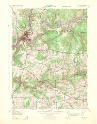 1943 Oil City1944 Print · USGSVenango County oil country is shown in detail during the early 1940s, centered on the industrial hub of Oil City. Genealogists can trace family names through dozens of rural schools like McCalmont Sch and churches such as St Marks Ch or Hoag Hill Ch.
 - 1946 Map of Tionesta
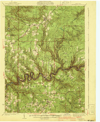
 1946 Tionesta1946 Print · USGSClarion and Forest Counties appear here in the 1940s, a period when rural schoolhouses and family-named hamlets still defined the interior ridges. Researchers can trace the Allegheny River and Clarion River or find specific landmarks like the Oil Field and Highland Township High Sch.
 - 1947 Map of Cherry Grove, 1972 Print
 1947 Cherry Grove1972 Print · USGSPotter County's high forest plateaus are captured here as they appeared in the late forties and early seventies. Researchers can trace the old Coudersport and Port Allegany Railroad and locate the Cherry Springs Fire Tower.
End of results
Showing maps 1-7 of 7
Top cities of Forest County
Frequently asked questions
- What are the different types of historical maps available for Forest County?
- What is the oldest map of Forest County?
- Where can I purchase historical maps of Forest County for my home or office?
- Where can I download high-res historical maps of Forest County?
- Are there historical topographic maps available for Forest County?
- Is there historical aerial imagery available for Forest County?
- Where are historical maps of Forest County sourced from?