1920s Maps of Forest County, Pennsylvania
Explore 6 historic maps of Forest County from the 1920s. These maps offer a rare glimpse into what life looked like during the 1920s — showing old roads, neighborhoods, homes, and landmarks that have changed or disappeared over time.
Whether you're researching your family's past, planning a metal detecting trip, or studying how Forest County's landscape evolved across the 1920s, these high-resolution maps are a powerful tool for exploring the history of this region.
- Focus on a specific era: All maps on this page are from the 1920s, giving you a focused view of this time period.
- See what’s changed: Compare century-old streets, trails, and buildings to today's modern landscape using overlays and satellite layers.
- Research with precision: Use these maps for genealogy, historical research, land use analysis, or educational projects.
- View, download, or print: Maps are fully viewable online in high resolution, and can be downloaded or printed for your own records.
Start exploring Forest County's history through authentic maps from the 1920s. This is your window into the past.
Forest County, PA maps
(6)- 1922 Map of Oil City
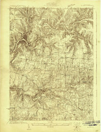 1922 Oil City1922 Print · USGSVenango County's river-driven economy and rural community structure are captured here in the early twenties, showing the intersection of heavy rail and upland farming. Researchers can trace family origins through numerous rural school sites like Rose School and old post offices at Cranberry PO or Davis Corners.2 unique versions available
 - 1922 Map of Tionesta, 1953 Print
 1922 Tionesta1953 Print · USGSNorthwestern Pennsylvania in the early twenties reveals a landscape defined by timber, the Allegheny River, and a dense network of country schools. Researchers can trace the legacy of small communities like Lucinda, Newmansville, and Fryburg alongside early railroad corridors.3 unique versions available
 - 1924 Map of Oil City
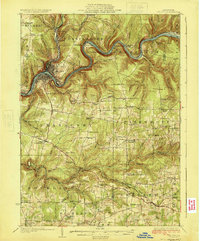 1924 Oil City1924 Print · USGSVenango County's industrial river valleys and rural plateaus are captured here in the early twenties as the oil economy shaped the land. Genealogists can trace family roots through numerous country schools and post offices like Cranberry PO, Monarch Park, and St Marks Church.4 unique versions available
 - 1924 Map of Tionesta
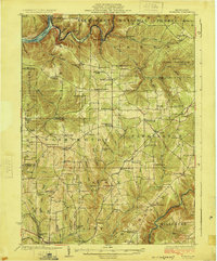 1924 Tionesta1924 Print · USGSThe northern Pennsylvania plateau comes alive in the early 1920s as the Allegheny National Forest was being established. Genealogists can trace hundreds of family-named landmarks and rural schoolhouses like Amsler School and Helen Furnace along the Baltimore and Ohio rail lines.4 unique versions available
 - 1927 Map of Tidioute
 1927 Tidioute1927 Print · USGSThe Allegheny River valley was a bustling corridor of rail and river industry in the late twenties. Genealogists can trace family footprints across dozens of local schoolhouses like Triumph Sch and rural hubs such as Endeavor or East Hickory.4 unique versions available
 - 1927 Map of Titusville, 1958 Print
 1927 Titusville1958 Print · USGSThe oil region of northwestern Pennsylvania is captured here in the late 1920s, centered on the industrial and rail hub of Titusville. Genealogists and researchers can locate the historic Drake Oil Well, dozens of country schools like Fink Ridge Sch, and the local Harrison Cem.3 unique versions available
End of results
Showing maps 1-6 of 6
Top cities of Forest County
Frequently asked questions
- What are the different types of historical maps available for Forest County?
- What is the oldest map of Forest County?
- Where can I purchase historical maps of Forest County for my home or office?
- Where can I download high-res historical maps of Forest County?
- Are there historical topographic maps available for Forest County?
- Is there historical aerial imagery available for Forest County?
- Where are historical maps of Forest County sourced from?