1960s Maps of Todd Township, Pennsylvania
Explore 5 historic maps of Todd Township from the 1960s. These maps offer a rare glimpse into what life looked like during the 1960s — showing old roads, neighborhoods, homes, and landmarks that have changed or disappeared over time.
Whether you're researching your family's past, planning a metal detecting trip, or studying how Todd Township's landscape evolved across the 1960s, these high-resolution maps are a powerful tool for exploring the history of this region.
- Focus on a specific era: All maps on this page are from the 1960s, giving you a focused view of this time period.
- See what’s changed: Compare century-old streets, trails, and buildings to today's modern landscape using overlays and satellite layers.
- Research with precision: Use these maps for genealogy, historical research, land use analysis, or educational projects.
- View, download, or print: Maps are fully viewable online in high resolution, and can be downloaded or printed for your own records.
Start exploring Todd Township's history through authentic maps from the 1960s. This is your window into the past.
Todd Township, PA maps
(5)- 1963 Map of Entriken, 1964 Print
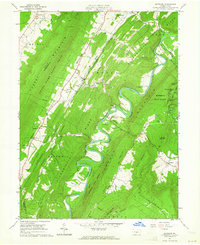 1963 Entriken1964 Print · USGSHuntsville's river valleys and ridgelines are captured here in the early sixties, showing the Raystown Branch Juniata River before major reservoir changes. Genealogists can locate family names at Brumbaugh Cem and community hubs like Salems Ch and Lincoln Grange Hall.5 unique versions available
 - 1963 Map of Cassville, 1965 Print
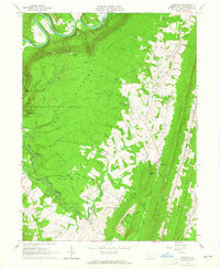 1963 Cassville1965 Print · USGSHuntingdon County ridge-and-valley country in the early 1960s shows a landscape of deep forests and small hill towns. Trace family roots at Sheridan Cem, find the Old Grade Railroad, or locate old landmarks like the Trough Creek Valley Sch and Todd Tabernacle.4 unique versions available
 - 1964 Map of Pittsburgh
 1964 Pittsburgh1964 Print · USGSWestern Pennsylvania in the late fifties and early sixties shows a landscape of powerful river industries and expanding highways. Genealogists and historians can trace the rail corridors of the Pennsylvania RR through industrial hubs like Johnstown, Altoona, and Nanty Glo.
 - 1968 Map of Saxton, 1970 Print
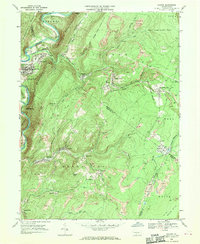 1968 Saxton1970 Print · USGSThe mining country of central Pennsylvania is documented here in the late sixties, where the Raystown Branch Juniata River meets a landscape of industry. Genealogists can trace family roots through settlements like Dudley and Broad Top City or find local burials at Grandview Cem.5 unique versions available
 - 1968 Map of Saltillo, 1970 Print
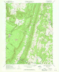 1968 Saltillo1970 Print · USGSThe coal and timber country of Huntingdon County is frozen in time here just before the close of the 1960s. Researchers can trace the legacy of industry and faith through locations like the Robertsdale mines, Eagle Foundry, and Calvary Ch.3 unique versions available
End of results
Showing maps 1-5 of 5
Top cities near Todd Township
- Frankstown Township historical maps
- Huntingdon historical maps
- Martinsburg historical maps
- Metal Township historical maps
- Williamsburg historical maps
- Saxton historical maps
See more
Top neighborhoods of Todd Township
- Paradise Furnace historical maps
- Salter historical maps
- Newburg historical maps
- Beavertown historical maps
- Joller historical maps
- Coles historical maps
See more
Frequently asked questions
- What are the different types of historical maps available for Todd Township?
- What is the oldest map of Todd Township?
- Where can I purchase historical maps of Todd Township for my home or office?
- Where can I download high-res historical maps of Todd Township?
- Are there historical topographic maps available for Todd Township?
- Is there historical aerial imagery available for Todd Township?
- Where are historical maps of Todd Township sourced from?