1990s Maps of Todd Township, Pennsylvania
Explore 2 historic maps of Todd Township from the 1990s. These maps offer a rare glimpse into what life looked like during the 1990s — showing old roads, neighborhoods, homes, and landmarks that have changed or disappeared over time.
Whether you're researching your family's past, planning a metal detecting trip, or studying how Todd Township's landscape evolved across the 1990s, these high-resolution maps are a powerful tool for exploring the history of this region.
- Focus on a specific era: All maps on this page are from the 1990s, giving you a focused view of this time period.
- See what’s changed: Compare century-old streets, trails, and buildings to today's modern landscape using overlays and satellite layers.
- Research with precision: Use these maps for genealogy, historical research, land use analysis, or educational projects.
- View, download, or print: Maps are fully viewable online in high resolution, and can be downloaded or printed for your own records.
Start exploring Todd Township's history through authentic maps from the 1990s. This is your window into the past.
Todd Township, PA maps
(2)- 1994 Map of Saltillo, 1997 Print
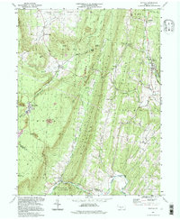 1994 Saltillo1997 Print · USGSThe borough of Saltillo and the mining-town heritage of Robertsdale are centered in this late-twentieth-century study of the Huntingdon and Fulton county border. Genealogists can trace family names at Cornelius Chapel or Mt Pleasant Cem and locate sites like Eagle Foundry.
 - 1994 Map of Cassville, 1997 Print
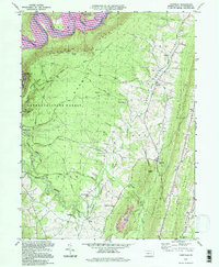 1994 Cassville1997 Print · USGSHuntingdon County at the mid-nineties shows a landscape of deep valleys and ridges between Raystown Lake and Sideling Hill. Researchers can trace local history through the Trough Creek Valley Sch and several country churches like Sheridan Ch.
End of results
Showing maps 1-2 of 2
Top cities near Todd Township
- Frankstown Township historical maps
- Huntingdon historical maps
- Martinsburg historical maps
- Metal Township historical maps
- Williamsburg historical maps
- Saxton historical maps
See more
Top neighborhoods of Todd Township
- Paradise Furnace historical maps
- Salter historical maps
- Newburg historical maps
- Beavertown historical maps
- Joller historical maps
- Coles historical maps
See more
Frequently asked questions
- What are the different types of historical maps available for Todd Township?
- What is the oldest map of Todd Township?
- Where can I purchase historical maps of Todd Township for my home or office?
- Where can I download high-res historical maps of Todd Township?
- Are there historical topographic maps available for Todd Township?
- Is there historical aerial imagery available for Todd Township?
- Where are historical maps of Todd Township sourced from?