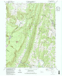
1994 Map of Saltillo
USGS Topo · Published 1997About this map
The borough of Saltillo sits at the foot of Jacks Mountain, serving as a focal point for this rural Huntingdon County landscape. This 1990s-era topographic view captures the deeply ridged terrain of south-central Pennsylvania, characterized by long, parallel elevations like Sideling Hill and Rocky Ridge. The settlement patterns here remain closely tied to the valleys and gaps, with small communities like Knightsville and Eagle Foundry dotting the lowlands. Extensive public lands, including State Game Lands No. 121 and portions of the Buchanan State Forest, dominate the high ground.
Find a feature on this map
53 named features on this map. Tap any name to fly to it.
Don’t see what you’re looking for? This feature index may not catch every label — zoom into the map to look around manually.
Map Details
Editions of this 1994 Saltillo Map
This is the sole edition of this map. No revisions or reprints were ever made.
Other maps of this area

1901 · Huntingdon
USGS Topo · 1:62,500

1904 · Huntingdon
USGS Topo · 1:62,500

1922 · Mt Union
USGS Topo · 1:48,000

1924 · Mt. Union
USGS Topo · 1:62,500

1930 · Broad Top
USGS Topo · 1:62,500

1933 · Broad Top
USGS Topo · 1:62,500

1939 · Orbisonia
USGS Topo · 1:62,500

1940 · Orbisonia
USGS Topo · 1:62,500

1944 · Orbisonia
USGS Topo · 1:62,500

1944 · Mt. Union
USGS Topo · 1:62,500