1990s Maps of Drumore Township, Pennsylvania
Explore 2 historic maps of Drumore Township from the 1990s. These maps offer a rare glimpse into what life looked like during the 1990s — showing old roads, neighborhoods, homes, and landmarks that have changed or disappeared over time.
Whether you're researching your family's past, planning a metal detecting trip, or studying how Drumore Township's landscape evolved across the 1990s, these high-resolution maps are a powerful tool for exploring the history of this region.
- Focus on a specific era: All maps on this page are from the 1990s, giving you a focused view of this time period.
- See what’s changed: Compare century-old streets, trails, and buildings to today's modern landscape using overlays and satellite layers.
- Research with precision: Use these maps for genealogy, historical research, land use analysis, or educational projects.
- View, download, or print: Maps are fully viewable online in high resolution, and can be downloaded or printed for your own records.
Start exploring Drumore Township's history through authentic maps from the 1990s. This is your window into the past.
Drumore Township, PA maps
(2)- 1992 Map of Quarryville, 1994 Print
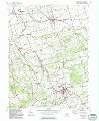 1992 Quarryville1994 Print · USGSCentral Lancaster County thrives as an agricultural and rail corridor during the late twentieth century. Genealogists can trace family roots through landmarks like Zion Ch and Ashland Sch, while the Strasburg RR remains a focal point of the local landscape.
 - 1999 Map of Wakefield, 2001 Print
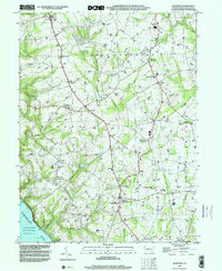 1999 Wakefield2001 Print · USGSThe southern Lancaster County countryside is captured here at the end of the twentieth century. Genealogists and historians can trace the region's deep roots through landmarks like the Fulton House, the Little Britain Ch, and old crossroads like Unicorn.
End of results
Showing maps 1-2 of 2
Top cities near Drumore Township
- Lancaster historical maps
- West Lampeter Township historical maps
- Willow Street historical maps
- Millersville historical maps
- Paradise Township historical maps
- Pequea historical maps
See more
Top neighborhoods of Drumore Township
- Buck historical maps
- Drumore Center historical maps
- Fairfield historical maps
- Furniss historical maps
- Hensel historical maps
- Benton historical maps
See more
Frequently asked questions
- What are the different types of historical maps available for Drumore Township?
- What is the oldest map of Drumore Township?
- Where can I purchase historical maps of Drumore Township for my home or office?
- Where can I download high-res historical maps of Drumore Township?
- Are there historical topographic maps available for Drumore Township?
- Is there historical aerial imagery available for Drumore Township?
- Where are historical maps of Drumore Township sourced from?