1940s Maps of Wright Township, Pennsylvania
Explore 5 historic maps of Wright Township from the 1940s. These maps offer a rare glimpse into what life looked like during the 1940s — showing old roads, neighborhoods, homes, and landmarks that have changed or disappeared over time.
Whether you're researching your family's past, planning a metal detecting trip, or studying how Wright Township's landscape evolved across the 1940s, these high-resolution maps are a powerful tool for exploring the history of this region.
- Focus on a specific era: All maps on this page are from the 1940s, giving you a focused view of this time period.
- See what’s changed: Compare century-old streets, trails, and buildings to today's modern landscape using overlays and satellite layers.
- Research with precision: Use these maps for genealogy, historical research, land use analysis, or educational projects.
- View, download, or print: Maps are fully viewable online in high resolution, and can be downloaded or printed for your own records.
Start exploring Wright Township's history through authentic maps from the 1940s. This is your window into the past.
Wright Township, PA maps
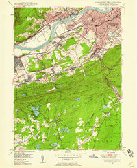
(5)- 1943 Map of Scranton
 1943 Scranton1943 Print · USGSNortheastern Pennsylvania’s coal and rail corridor comes to life in the 1940s, showcasing the dense urban industrial centers of the Wyoming Valley. Genealogists can locate family landmarks like the Fayette School and Locust Ridge School or trace the early paths of the DL & W and Erie railroads.
 - 1947 Map of Wilkes-Barre West, 1958 Print
 1947 Wilkes-Barre West1958 Print · USGSThe Wyoming Valley anthracite region thrives in the late 1940s, showing a landscape defined by massive coal operations and a dense rail network. Trace local family roots through sites like Shawnee Cem, Sugar Notch, and the neighborhood schools of Wilkes-Barre.6 unique versions available
 - 1947 Map of Wilkes-Barre East, 1959 Print
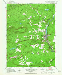
 1947 Wilkes-Barre East1959 Print · USGSWilkes-Barre and the eastern ridges of the Wyoming Valley are shown in the post-war era as the anthracite coal industry shaped the landscape. Genealogists can trace family connections at Georgetown, Laurel Run, and Holy Trinity Cem, or locate landmarks like Ochre Mill and Oliver Sch.7 unique versions available
 - 1947 Map of White Haven, 1966 Print
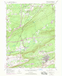
 1947 White Haven1966 Print · USGSThe Lehigh River valley in the late 1940s is a landscape defined by industry and rail, where coal mining and transportation intersect. Genealogists can trace family roots through settlements like White Haven and Tannery, or locate local landmarks like Ripple Sch and St Patrick Cem.4 unique versions available
 - 1948 Map of Freeland, 1969 Print
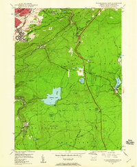
 1948 Freeland1969 Print · USGSLuzerne County's anthracite region is captured here during a period of industrial change after the war. Local historians can trace the development of Freeland and Upper Lehigh alongside the rail networks of the Central RR of New Jersey and the Lehigh Valley RR.3 unique versions available
End of results
Showing maps 1-5 of 5
Top cities near Wright Township
- Scranton historical maps
- Wilkes-Barre historical maps
- Hazleton historical maps
- Kingston historical maps
- Nanticoke historical maps
- Plains Township historical maps
See more
Top neighborhoods of Wright Township
- Wech Corners historical maps
- Albert historical maps
- Lindbergh historical maps
- Rippletown historical maps
- Rita historical maps
Frequently asked questions
- What are the different types of historical maps available for Wright Township?
- What is the oldest map of Wright Township?
- Where can I purchase historical maps of Wright Township for my home or office?
- Where can I download high-res historical maps of Wright Township?
- Are there historical topographic maps available for Wright Township?
- Is there historical aerial imagery available for Wright Township?
- Where are historical maps of Wright Township sourced from?