1990s Maps of Brown Township, Pennsylvania
Explore 6 historic maps of Brown Township from the 1990s. These maps offer a rare glimpse into what life looked like during the 1990s — showing old roads, neighborhoods, homes, and landmarks that have changed or disappeared over time.
Whether you're researching your family's past, planning a metal detecting trip, or studying how Brown Township's landscape evolved across the 1990s, these high-resolution maps are a powerful tool for exploring the history of this region.
- Focus on a specific era: All maps on this page are from the 1990s, giving you a focused view of this time period.
- See what’s changed: Compare century-old streets, trails, and buildings to today's modern landscape using overlays and satellite layers.
- Research with precision: Use these maps for genealogy, historical research, land use analysis, or educational projects.
- View, download, or print: Maps are fully viewable online in high resolution, and can be downloaded or printed for your own records.
Start exploring Brown Township's history through authentic maps from the 1990s. This is your window into the past.
Brown Township, PA maps
(6)- 1994 Map of Cedar Run, 1998 Print
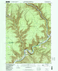 1994 Cedar Run1998 Print · USGSThe deep canyons of the Grand Canyon of Pennsylvania are captured here during the late twentieth century. Researchers can trace the river-level settlements of Blackwell and Cedar Run or locate high-country landmarks like Mine Hole Hill and Leetonia.
 - 1994 Map of Slate Run, 1999 Print
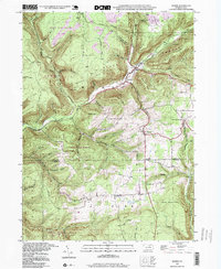
 1994 Slate Run1999 Print · USGSThe wilderness at the junction of Lycoming, Potter, and Clinton counties is captured here in the 1990s. Local researchers can trace the rugged topography of Pine Creek Gorge, the isolated settlement of Slate Run, and the high-elevation Pump Station Fire Tower.
 - 1994 Map of Cammal, 1999 Print
 1994 Cammal1999 Print · USGSLycoming County's deep river valleys and high plateaus are captured here in the 1990s, centered on the Pine Creek corridor. Genealogists and hikers can trace the Penn Central tracks past Cammal, Ross Siding, and remote clearings like Beulah Land.
 - 1994 Map of Morris, 1999 Print
 1994 Morris1999 Print · USGSThe Pennsylvania backcountry near the Tioga and Lycoming border is captured here in the 1990s, centered on the valley hamlets of Morris and Hoytville. Researchers can trace old mountain roads and local landmarks like Lewis Cem and the Crawford Fire Tower.
 - 1994 Map of Lee Fire Tower, 1999 Print
 1994 Lee Fire Tower1999 Print · USGSThe convergence of three state forests in the Pennsylvania highlands is documented in the mid-1990s, showing a land of deep hollows and timber ridges. Researchers can trace forest industrial history via the CLAY MINE, PIPELINE ROAD, and the landmark Lee Fire Tower.
 - 1994 Map of English Center, 1999 Print
 1994 English Center1999 Print · USGSLycoming County’s rugged northern highlands are captured here in the late twentieth century, showing a region defined by conservation lands and coal extraction. Genealogists and historians can locate the isolated Carsontown Cemetery and traces of mountain life in English Center or Brookside.
End of results
Showing maps 1-6 of 6
Top cities near Brown Township
- Morris Township historical maps
- Gaines Township historical maps
- Gallagher Township historical maps
- Abbott Township historical maps
- Duncan Township historical maps
- Stony Fork historical maps
Top neighborhoods of Brown Township
- Hilborn historical maps
- Beulah Land historical maps
- Slate Run historical maps
- Cedar Pines historical maps
- Cedar Run historical maps
Frequently asked questions
- What are the different types of historical maps available for Brown Township?
- What is the oldest map of Brown Township?
- Where can I purchase historical maps of Brown Township for my home or office?
- Where can I download high-res historical maps of Brown Township?
- Are there historical topographic maps available for Brown Township?
- Is there historical aerial imagery available for Brown Township?
- Where are historical maps of Brown Township sourced from?