1950s Maps of Mercer County, Pennsylvania
Explore 15 historic maps of Mercer County from the 1950s. These maps offer a rare glimpse into what life looked like during the 1950s — showing old roads, neighborhoods, homes, and landmarks that have changed or disappeared over time.
Whether you're researching your family's past, planning a metal detecting trip, or studying how Mercer County's landscape evolved across the 1950s, these high-resolution maps are a powerful tool for exploring the history of this region.
- Focus on a specific era: All maps on this page are from the 1950s, giving you a focused view of this time period.
- See what’s changed: Compare century-old streets, trails, and buildings to today's modern landscape using overlays and satellite layers.
- Research with precision: Use these maps for genealogy, historical research, land use analysis, or educational projects.
- View, download, or print: Maps are fully viewable online in high resolution, and can be downloaded or printed for your own records.
Start exploring Mercer County's history through authentic maps from the 1950s. This is your window into the past.
Mercer County, PA maps
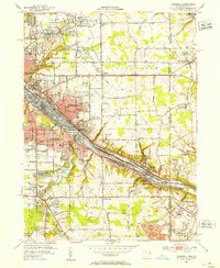
(15)- 1950 Map of Cleveland
 1950 Cleveland1950 Print · USGSCovers Mercer County, including Cleveland, Akron, and other nearby areas
 - 1951 Map of Campbell, 1953 Print
 1951 Campbell1953 Print · USGSThe Mahoning River valley in the early fifties shows a dense industrial corridor of rails and riverside towns on the Ohio-Pennsylvania line. Genealogists can trace family landmarks like White Sch, St Johns Cem, and Holy Rosary Cem.
 - 1954 Map of Sharon West, 1956 Print
 1954 Sharon West1956 Print · USGSThe industrial heart of the Ohio-Pennsylvania border comes alive in the mid-1950s, centered on the bustling rail hubs and river towns. Researchers can trace family history through the neighborhoods of Hubbard, locate the Slope Ch, or study the grounds of Oakwood Cem.
 - 1956 Map of Cleveland, 1967 Print
 1956 Cleveland1967 Print · USGSNortheast Ohio and Western Pennsylvania are shown at their industrial height during the mid-fifties, from the steel mills to the lakeshore. Researchers can trace the massive Ravenna Arsenal, the Ohio Turnpike, and vanished rail sidings of the B & O RR.3 unique versions available
 - 1957 Map of Warren, 1964 Print
 1957 Warren1964 Print · USGSThe northern Pennsylvania oil and timber country comes into focus in the mid-fifties, showing the region before modern highway expansions. Trace the industrial rail networks of the Pennsylvania RR and the early Allegheny River Reservoir near Warren and Oil City.4 unique versions available
 - 1958 Map of Warren
 1958 Warren1958 Print · USGSNorthern Pennsylvania’s timber and oil country is captured here during the late fifties, showing the interplay of industrial valleys and vast state forests. Genealogists can trace family connections across the Cornplanter Indian Reservation or through rail hubs like Oil City and Saint Marys.
 - 1958 Map of Sharpsville, 1959 Print
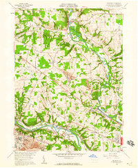
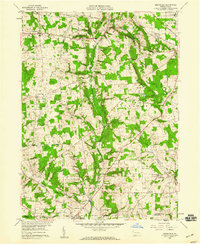
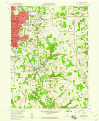
 1958 Sharpsville1959 Print · USGSMercer County's river valley and rail networks are captured here in the late fifties as suburban growth meets long-standing rural townships. Researchers can pinpoint family history at Fell Cem, local schools like Pebly Sch, and the industrial corridors of the Erie railroad.5 unique versions available
 - 1958 Map of Edinburg, 1959 Print
 1958 Edinburg1959 Print · USGSThe Shenango and Mahoning rivers meet in the late fifties amidst a dense network of major railroads and industrial hubs. Genealogists and historians can trace local landmarks like Kings Chapel, Hopewell Cem, and the now-vanished New Castle Trade Sch.4 unique versions available
 - 1958 Map of Greenfield, 1959 Print
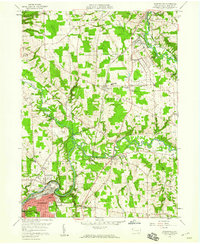
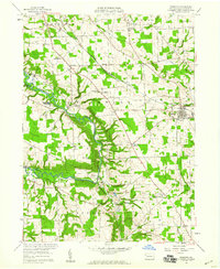
 1958 Greenfield1959 Print · USGSMercer and Lawrence Counties are shown here in the late fifties, characterized by a network of rural schoolhouses and family cemeteries. Researchers can trace local history through landmarks like Reed Sch, Zahniser Cem, and the small settlement of Hoagland along Beaver Run.2 unique versions available
 - 1958 Map of Greensville West, 1960 Print
 1958 Greensville West1960 Print · USGSWestern Pennsylvania in the late fifties shows a bustling industrial and academic hub centered on the Shenango River. Genealogists and historians can trace the foundations of Greenville, from Thiel College to the path of the historic Erie Extension Canal.4 unique versions available
 - 1958 Map of Fredonia, 1960 Print
 1958 Fredonia1960 Print · USGSMercer County in the late fifties is captured here as a landscape of rural schoolhouses, country churches, and active rail lines. Researchers can trace family roots through sites like St Johns Ch, Reichard Sch, and the riverside settlement of New Hamburg.3 unique versions available
 - 1958 Map of Greensville East, 1960 Print
 1958 Greensville East1960 Print · USGSMercer County is captured in the late fifties as a bustling crossroads of the New York Central and other major railroads. Genealogists and local researchers can trace family landmarks like Leechs Corners, Stevenson Cem, and Camp Rowland.3 unique versions available
 - 1958 Map of New Castle North, 1960 Print
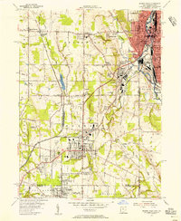
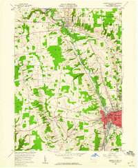
 1958 New Castle North1960 Print · USGSLawrence County was undergoing significant post-war growth in the late fifties as residential neighborhoods expanded north from New Castle toward New Wilmington. Researchers can locate long-standing institutions like Westminster College and trace family plots at Oak Park Cemetery or Neshannock Church Cemetery.5 unique versions available
 - 1958 Map of Sharon East, 1960 Print
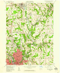
 1958 Sharon East1960 Print · USGSMercer County during the late fifties shows the steady outward growth of Sharon and Farrell into the surrounding townships. Genealogists and local historians can trace family locations through numerous sites like Morefield Cem, Township High Sch, and the West Middlesex Airport.5 unique versions available
 - 1959 Map of Warren
 1959 Warren1959 Print · USGSNorthern Pennsylvania's oil and timber country comes alive in this late-fifties study of the forest-clad plateaus. Trace the historic Cornplanter (Indian Reservation), the sprawling Oil Field, and the rail lines of the Pennsylvania RR.2 unique versions available
End of results
Showing maps 1-15 of 15
Top cities of Mercer County
- Hermitage historical maps
- Sharon historical maps
- Grove City historical maps
- Farrell historical maps
- Greenville historical maps
- Sharpsville historical maps
See more
Frequently asked questions
- What are the different types of historical maps available for Mercer County?
- What is the oldest map of Mercer County?
- Where can I purchase historical maps of Mercer County for my home or office?
- Where can I download high-res historical maps of Mercer County?
- Are there historical topographic maps available for Mercer County?
- Is there historical aerial imagery available for Mercer County?
- Where are historical maps of Mercer County sourced from?