1950s Maps of Shenango Township, Pennsylvania
Explore 6 historic maps of Shenango Township from the 1950s. These maps offer a rare glimpse into what life looked like during the 1950s — showing old roads, neighborhoods, homes, and landmarks that have changed or disappeared over time.
Whether you're researching your family's past, planning a metal detecting trip, or studying how Shenango Township's landscape evolved across the 1950s, these high-resolution maps are a powerful tool for exploring the history of this region.
- Focus on a specific era: All maps on this page are from the 1950s, giving you a focused view of this time period.
- See what’s changed: Compare century-old streets, trails, and buildings to today's modern landscape using overlays and satellite layers.
- Research with precision: Use these maps for genealogy, historical research, land use analysis, or educational projects.
- View, download, or print: Maps are fully viewable online in high resolution, and can be downloaded or printed for your own records.
Start exploring Shenango Township's history through authentic maps from the 1950s. This is your window into the past.
Shenango Township, PA maps
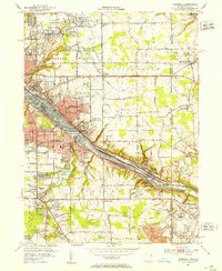
(6)- 1950 Map of Cleveland
 1950 Cleveland1950 Print · USGSCovers Shenango Township, including Cleveland, Akron, and other nearby areas
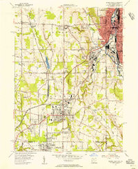
 - 1951 Map of Campbell, 1953 Print
 1951 Campbell1953 Print · USGSThe Mahoning River valley in the early fifties shows a dense industrial corridor of rails and riverside towns on the Ohio-Pennsylvania line. Genealogists can trace family landmarks like White Sch, St Johns Cem, and Holy Rosary Cem.
 - 1954 Map of Sharon West, 1956 Print
 1954 Sharon West1956 Print · USGSThe industrial heart of the Ohio-Pennsylvania border comes alive in the mid-1950s, centered on the bustling rail hubs and river towns. Researchers can trace family history through the neighborhoods of Hubbard, locate the Slope Ch, or study the grounds of Oakwood Cem.
 - 1956 Map of Cleveland, 1967 Print
 1956 Cleveland1967 Print · USGSNortheast Ohio and Western Pennsylvania are shown at their industrial height during the mid-fifties, from the steel mills to the lakeshore. Researchers can trace the massive Ravenna Arsenal, the Ohio Turnpike, and vanished rail sidings of the B & O RR.3 unique versions available
 - 1958 Map of Edinburg, 1959 Print
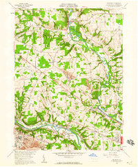 1958 Edinburg1959 Print · USGSThe Shenango and Mahoning rivers meet in the late fifties amidst a dense network of major railroads and industrial hubs. Genealogists and historians can trace local landmarks like Kings Chapel, Hopewell Cem, and the now-vanished New Castle Trade Sch.4 unique versions available
 - 1958 Map of Sharon East, 1960 Print
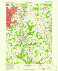 1958 Sharon East1960 Print · USGSMercer County during the late fifties shows the steady outward growth of Sharon and Farrell into the surrounding townships. Genealogists and local historians can trace family locations through numerous sites like Morefield Cem, Township High Sch, and the West Middlesex Airport.5 unique versions available
End of results
Showing maps 1-6 of 6
Top cities near Shenango Township
- Youngstown historical maps
- Boardman historical maps
- New Castle historical maps
- Hermitage historical maps
- Sharon historical maps
- Struthers historical maps
See more
Top neighborhoods of Shenango Township
Frequently asked questions
- What are the different types of historical maps available for Shenango Township?
- What is the oldest map of Shenango Township?
- Where can I purchase historical maps of Shenango Township for my home or office?
- Where can I download high-res historical maps of Shenango Township?
- Are there historical topographic maps available for Shenango Township?
- Is there historical aerial imagery available for Shenango Township?
- Where are historical maps of Shenango Township sourced from?