Old Maps of Tobyhanna Township, Pennsylvania for Hiking & Exploration
Hike through history with 67 historic maps of Tobyhanna Township. Explore old trails, ghost towns, and forgotten backroads — perfect for outdoor adventurers and local explorers.
- Rediscover forgotten places: Map out old mining camps, roads, and footpaths that no longer exist on modern maps.
- Layer with modern tools: Combine with LiDAR or satellite views to plan hikes through historical terrain.
- Made for exploration: Popular among hikers, overlanders, and local history lovers.
Use these maps to find adventure and explore the hidden past of Tobyhanna Township.
Tobyhanna Township, PA maps
(67)- 1919 Map of Pocono
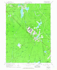
 1919 Pocono1919 Print · USGSMonroe County was a critical military and rail corridor at the close of the Great War. Researchers can trace the massive Tobyhanna Military Reservation and the early rail-centered footprints of Mount Pocono, Tannerville, and Cresco.
 - 1921 Map of Pocono, 1962 Print
 1921 Pocono1962 Print · USGSThe Pocono Mountains at the start of the 1920s reveal a landscape of military training grounds, remote mountain schools, and early summer resorts. Trace the rail lines of the Wilkes-Barre and Eastern RR or locate rural landmarks like Cherry Lane Church and Beaver Brook School.
 - 1922 Map of Stoddartsville, 1958 Print
 1922 Stoddartsville1958 Print · USGSThe Pennsylvania Poconos at the turn of the century show a landscape of high timber ridges and early mountain resorts. Genealogists and hikers can trace the original paths to Stoddartsville, identify the old Fayette School, or follow the Wilkes-Barre and Eastern rail line.2 unique versions available
 - 1923 Map of Pocono
 1923 Pocono1923 Print · USGSMonroe County was evolving into a mountain retreat in the early twenties, connected by the Delaware Lackawanna and Western RR. Researchers can trace early resort life at Lake Naomi, find rural schools like Butz School, and locate the expansive Artillery Reservation.5 unique versions available
 - 1924 Map of Stoddartsville
 1924 Stoddartsville1924 Print · USGSUpper Carbon and Monroe counties are shown in the early twenties as a landscape of timbered hills and headwater streams. Genealogists can locate old rural landmarks like Bradys Switch, the Leonardsville settlement, and the Locust Ridge School.5 unique versions available
 - 1943 Map of Scranton
 1943 Scranton1943 Print · USGSNortheastern Pennsylvania’s coal and rail corridor comes to life in the 1940s, showcasing the dense urban industrial centers of the Wyoming Valley. Genealogists can locate family landmarks like the Fayette School and Locust Ridge School or trace the early paths of the DL & W and Erie railroads.
 - 1943 Map of Stoddartsville
 1943 Stoddartsville1943 Print · USGSThe Pocono Plateau at the height of the Second World War shows a landscape defined by river valleys and developing recreation preserves. Genealogists and local historians can trace rural schoolhouses and small settlements like Stoddartsville, Albrightsville, and the Fishery Sch.
 - 1943 Map of Pocono
 1943 Pocono1943 Print · USGSMonroe County was a well-established retreat and transportation hub in the early 1940s, centered around the Delaware Lackawanna and Western railroad. Researchers can trace old mountain roads and family-named landmarks like Camelback Mountain, Naomi Pines Sch, and the Mount Pocono Airport.
 - 1950 Map of Scranton, 1952 Print
 1950 Scranton1952 Print · USGSMid-century Northeast Pennsylvania and the Hudson Valley come alive in this survey of the tri-state region. Genealogists and historians can trace the dense rail networks of the Erie RR and DL&W RR between industrial hubs like Scranton and Wilkes-Barre.
 - 1953 Map of Scranton
 1953 Scranton1953 Print · USGSNortheastern Pennsylvania and the Catskills are shown in great detail during the early fifties, a time when rail lines and river valleys dictated the region's growth. Genealogists and historians can trace the industrial hearts of Scranton and Wilkes-Barre or locate remote landmarks like High Point and Lake Wallenpaupack.
 - 1959 Map of Scranton
 1959 Scranton1959 Print · USGSThe northern coalfields and the Hudson Valley meet in this mid-century survey of the Pennsylvania and New York borderlands. Genealogists and historians can trace the intricate rail networks of the Erie Railroad and the vast waters of Lake Wallenpaupack.2 unique versions available
 - 1959 Map of Pocono
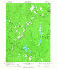
 1959 Pocono1959 Print · USGSThe Pocono Mountains region is captured here in the late fifties, showcasing its evolution from a railway-dependent timber and ice landscape to a premier resort destination. Researchers can locate dozens of country schoolhouses like Maplewood Sch and trace the paths of the Erie RR through Hawley and Kimbles.
 - 1962 Map of Scranton, 1977 Print
 1962 Scranton1977 Print · USGSThe industrial heart of eastern Pennsylvania and the New York Catskills are captured here in the early sixties. Genealogists and historians can trace the dense valley settlements from Scranton to Wilkes-Barre and the rail lines of the Erie Lackawanna Railroad.2 unique versions available
 - 1965 Map of Scranton
 1965 Scranton1965 Print · USGSThe tri-state highlands of Pennsylvania, New York, and New Jersey come alive in the mid-sixties as industry and recreation converge. Trace the intricate rail lines of the Erie Lackawanna RR or locate landmarks like the U S Military Academy.2 unique versions available
 - 1965 Map of Tobyhanna, 1967 Print
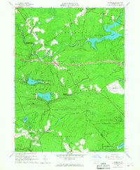
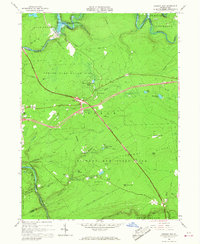
 1965 Tobyhanna1967 Print · USGSMonroe County was a hub of military logistics and emerging lakeside communities in the mid-sixties. Researchers can trace the sprawling Tobyhanna Army Depot, the Erie Lackawanna rail line, and early developments at Stillwater Lake Estates.3 unique versions available
 - 1965 Map of Thornhurst, 1967 Print
 1965 Thornhurst1967 Print · USGSThe Lehigh River corridor near Thornhurst shows a landscape of public forests and wetlands in the mid-1960s. Researchers can locate burial grounds like Pine Grove Cem and explore named swales such as City of Rome Dark Swamp.6 unique versions available
 - 1965 Map of Blakeslee, 1967 Print
 1965 Blakeslee1967 Print · USGSThe Pocono region undergoes a major shift toward recreation and transit in the 1960s as new highways bisect the forest. You can trace the footprint of Pocono International Raceway and early resorts like Big Boulder Ski Resort or Split Rock.4 unique versions available
 - 1965 Map of Pleasant View Summit, 1967 Print
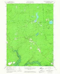 1965 Pleasant View Summit1967 Print · USGSThe Luzerne County highlands in the mid-sixties are shown here as a landscape of conservation and water management. You can trace the Francis E Walter Reservoir, the historic settlement at Stoddartsville, and an Old Railroad Grade.4 unique versions available
 - 1966 Map of Hickory Run, 1967 Print
 1966 Hickory Run1967 Print · USGSCarbon County is captured during its mid-century transition into a recreational hub as the new interstate highway system intersects old mountain roads. Trace the evolution of this landscape from the Central Railroad of New Jersey to the Boulder Field and Hickory Run State Park.3 unique versions available
 - 1966 Map of Pocono Pines, 1967 Print
 1966 Pocono Pines1967 Print · USGSThe Pocono plateau in the mid-sixties shows a landscape of rising lakeside vacation communities and vast protected woodlands. Researchers can trace the Erie-Lackawanna rail lines, the Old Railroad Grade, and local centers like Pocono Pines.6 unique versions available
 - 1976 Map of Tobyhanna, 1978 Print
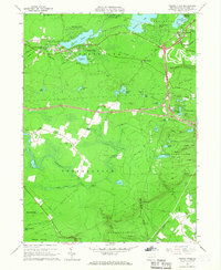
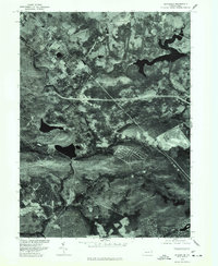
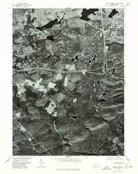
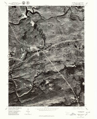
 1976 Tobyhanna1978 Print · USGSThe Monroe County landscape near the border of Lackawanna County is shown through detailed 1970s aerial photography. Researchers can examine the physical layout of Tobyhanna and Gouldsboro or trace the water levels of Tobyhanna Lake.
 - 1976 Map of Blakeslee, 1978 Print
 1976 Blakeslee1978 Print · USGSMonroe County was undergoing significant recreational growth in the mid-1970s, as captured in this detailed aerial orthophotograph. Researchers can trace the development of residential communities at Indian Mountain Lake and Split Rock or study the shoreline of Pocono Lake.
 - 1976 Map of Pocono Pines, 1978 Print
 1976 Pocono Pines1978 Print · USGSThe Pocono Mountains landscape in the mid-seventies reveals a mix of dense forest and growing recreational communities. Genealogists and local historians can trace the footprint of Pocono Pines and the early development surrounding Pocono Lake and Crescent Lake.
 - 1976 Map of Pleasant View Summit, 1979 Print
 1976 Pleasant View Summit1979 Print · USGSLuzerne County's forested heights and river valleys are captured in this mid-seventies aerial survey. Local historians can trace the early footprints of Stoddartsville and Shades Glen along the course of the Lehigh River.
 - 1976 Map of Hickory Run, 1979 Print
 1976 Hickory Run1979 Print · USGSCarbon County in the mid-seventies shows a landscape defined by its river corridors and the growing reach of highway infrastructure. Researchers can trace the layout of small settlements like Leonardsville and Saylorville along the banks of Hickory Run.
Showing maps 1-25 of 67
Top cities near Tobyhanna Township
- Scranton historical maps
- Plains Township historical maps
- Tobyhanna historical maps
- Moosic historical maps
- Jim Thorpe historical maps
- Mount Pocono historical maps
See more
Top neighborhoods of Tobyhanna Township
- Blakeslee historical maps
- Pocono Pines historical maps
- Pocono Summit historical maps
- Pocono Pines historical maps
- Wagners Forest Park historical maps
- Camelot Forest historical maps
See more
Frequently asked questions
- What are the different types of historical maps available for Tobyhanna Township?
- What is the oldest map of Tobyhanna Township?
- Where can I purchase historical maps of Tobyhanna Township for my home or office?
- Where can I download high-res historical maps of Tobyhanna Township?
- Are there historical topographic maps available for Tobyhanna Township?
- Is there historical aerial imagery available for Tobyhanna Township?
- Where are historical maps of Tobyhanna Township sourced from?