1890s Maps of Montgomery County, Pennsylvania
Explore 18 historic maps of Montgomery County from the 1890s. These maps offer a rare glimpse into what life looked like during the 1890s — showing old roads, neighborhoods, homes, and landmarks that have changed or disappeared over time.
Whether you're researching your family's past, planning a metal detecting trip, or studying how Montgomery County's landscape evolved across the 1890s, these high-resolution maps are a powerful tool for exploring the history of this region.
- Focus on a specific era: All maps on this page are from the 1890s, giving you a focused view of this time period.
- See what’s changed: Compare century-old streets, trails, and buildings to today's modern landscape using overlays and satellite layers.
- Research with precision: Use these maps for genealogy, historical research, land use analysis, or educational projects.
- View, download, or print: Maps are fully viewable online in high resolution, and can be downloaded or printed for your own records.
Start exploring Montgomery County's history through authentic maps from the 1890s. This is your window into the past.
Montgomery County, PA maps
(18)- 1890 Map of Doylestown
 1890 Doylestown1890 Print · USGSBucks County in the late nineteenth century is captured here as a landscape of established mill towns and farming crossroads. Local historians can trace early rail routes like the Doylestown Branch and discover forgotten names such as New Galena, Griers Corner, and Hinkletown.
 - 1890 Map of Quakertown
 1890 Quakertown1890 Print · USGSUpper Bucks and Montgomery counties are shown in the 1880s as a thriving corridor of rail towns and rural villages. Researchers can trace the original routes of the Perkasie and Sellersville settlements or locate family homesteads near Trumbauersville and Tylers Port.
 - 1891 Map of Doylestown
 1891 Doylestown1891 Print · USGSBucks County and the Delaware River valley are captured in the late Victorian era as the region's agricultural and industrial patterns were firmly established. Genealogists and historians can trace old homestead locations near Kellers Church, identify stops along the Penna Railroad, and find riverside hamlets like Raven Rock and Tumble.11 unique versions available
 - 1891 Map of Philadelphia
 1891 Philadelphia1891 Print · USGSPhiladelphia and its New Jersey neighbors are captured in the late Victorian era as rail and river commerce defined the region. Genealogists and historians can trace family-named sites and vanished river features like Windmill Island, Haddonfield, and the U.S. Navy Yard.
 - 1893 Map of Germantown
 1893 Germantown1893 Print · USGSThe outskirts of Philadelphia and Montgomery County are shown in the late nineteenth century as rail lines transformed rural townships. Genealogists and historians can trace old property lines and depots from Warminster P.O. to the U.S. Arsenal.
 - 1894 Map of Quakertown
 1894 Quakertown1894 Print · USGSSoutheast Pennsylvania at the close of the nineteenth century reveals a flourishing landscape of rail-linked villages and fertile creek valleys. Genealogists can trace family roots through dozens of named settlements like Trumbauersville, Zion Hill, and Applebachsville.9 unique versions available
 - 1894 Map of Chester, 1954 Print
 1894 Chester1954 Print · USGSThe Delaware River corridor near Chester was a hive of rail activity and water-powered industry at the close of the century. Genealogists and historians can trace family-named mills such as Llewellyn Mills or visit the campus of the Williamson School and the borough of Media.2 unique versions available
 - 1894 Map of Philadelphia, 1958 Print
 1894 Philadelphia1958 Print · USGSPhiladelphia and Camden are shown at the height of the Victorian era, characterized by dense rail corridors and a bustling maritime waterfront. Genealogists and researchers can trace 19th-century neighborhoods and landmarks like Fort Mifflin, Paschallville, and the Alms House.
 - 1894 Map of Norristown, 1959 Print
 1894 Norristown1959 Print · USGSSoutheast Pennsylvania at the end of the nineteenth century reveals a landscape defined by the Schuylkill River and a dense network of early railroads. Researchers can trace ancestral roots through old settlements like Skippack, Lansdale, and the rail junctions of the Perkiomen RR and Stony Creek RR.
 - 1894 Map of Germantown, 1961 Print
 1894 Germantown1961 Print · USGSThe northern Philadelphia suburbs and rural Montgomery County are captured here just as the railroad was transforming local life. Genealogists can trace family names and old property lines across Germantown, Hatboro, and the historic U.S. Arsenal.
 - 1895 Map of Norristown, 1898 Print
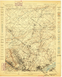
 1895 Norristown1898 Print · USGSMontgomery County at the end of the 19th century is a landscape of thriving river towns and bustling rail corridors. Researchers can trace the Victorian-era footprints of Norristown and Lansdale or locate historic landmarks like Valley Forge and Perkiomen Bridge.11 unique versions available
 - 1896 Map of Germantown
 1896 Germantown1896 Print · USGSThe northern reaches of Philadelphia and lower Bucks County are shown in the late nineteenth century as rail lines transformed rural villages into bustling suburbs. Trace early transport routes along Street Road or locate family landmarks near Hatboro, Ambler, and the U. S. Arsenal.
 - 1896 Map of Philadelphia
 1896 Philadelphia1896 Print · USGSPhiladelphia and its South Jersey neighbors appear at a peak of late-nineteenth-century industrial and maritime expansion. Genealogists and historians can trace the early layouts of Woodbury and Gloucester, or locate landmarks like Fort Mifflin and the U.S. Navy Yard along the riverfront.
 - 1896 Map of Norristown
 1896 Norristown1896 Print · USGSMontgomery County in the mid-1890s reveals a landscape of growing railroad towns and historic creek-side settlements. Genealogists can trace family footprints near Waterloo Mills, the historic Perkiomen Bridge, and across the townships from Lansdale to Norristown.
 - 1896 Map of Chester
 1896 Chester1896 Print · USGSThe industrial corridor along the Delaware River thrives at the close of the nineteenth century as railroads and mills reshape the landscape. Genealogists can trace early homesteads and institutions like the Williamson School, Sharon Academy, and Sycamore Mills.
 - 1898 Map of Chester
 1898 Chester1898 Print · USGSThe Delaware River shoreline at the end of the nineteenth century reveals a landscape of industrial riverfronts and emerging mill towns. Genealogists and historians can trace family roots through numerous small settlements and institutions like Village Green, Booth Corner, and the Williamson School.10 unique versions available
 - 1898 Map of Philadelphia
 1898 Philadelphia1898 Print · USGSPhiladelphia and Camden emerge as a Victorian-era industrial powerhouse at the turn of the century, knit together by ferry and rail. Researchers can trace ancestral roots in vanished neighborhoods like Paschallville or locate landmarks like the Alms House and Fort Mifflin.9 unique versions available
 - 1899 Map of Germantown
 1899 Germantown1899 Print · USGSPhiladelphia and its northern townships are documented in the late nineteenth century as the suburban rail network expanded. Genealogists can trace family roots through historic settlements like Hatboro, Ambler, and the neighborhood of Chestnut Hill.9 unique versions available
End of results
Showing maps 1-18 of 18
Top cities of Montgomery County
- Abington Township historical maps
- Cheltenham Township historical maps
- Norristown historical maps
- Horsham Township historical maps
- Pottstown historical maps
- Whitemarsh Township historical maps
See more
Frequently asked questions
- What are the different types of historical maps available for Montgomery County?
- What is the oldest map of Montgomery County?
- Where can I purchase historical maps of Montgomery County for my home or office?
- Where can I download high-res historical maps of Montgomery County?
- Are there historical topographic maps available for Montgomery County?
- Is there historical aerial imagery available for Montgomery County?
- Where are historical maps of Montgomery County sourced from?