1960s Maps of Montgomery County, Pennsylvania
Explore 15 historic maps of Montgomery County from the 1960s. These maps offer a rare glimpse into what life looked like during the 1960s — showing old roads, neighborhoods, homes, and landmarks that have changed or disappeared over time.
Whether you're researching your family's past, planning a metal detecting trip, or studying how Montgomery County's landscape evolved across the 1960s, these high-resolution maps are a powerful tool for exploring the history of this region.
- Focus on a specific era: All maps on this page are from the 1960s, giving you a focused view of this time period.
- See what’s changed: Compare century-old streets, trails, and buildings to today's modern landscape using overlays and satellite layers.
- Research with precision: Use these maps for genealogy, historical research, land use analysis, or educational projects.
- View, download, or print: Maps are fully viewable online in high resolution, and can be downloaded or printed for your own records.
Start exploring Montgomery County's history through authentic maps from the 1960s. This is your window into the past.
Montgomery County, PA maps
(15)- 1960 Map of Newark
 1960 Newark1960 Print · USGSThe industrial heart of the Mid-Atlantic is shown at mid-century, stretching from the dense urban centers of Newark and Philadelphia to the Blue Mountain ridges. Researchers can trace historic rail lines, coastal defenses at Fort Hancock, and the riverfront growth of Trenton and Easton.3 unique versions available
 - 1960 Map of Perkiomenville, 1963 Print
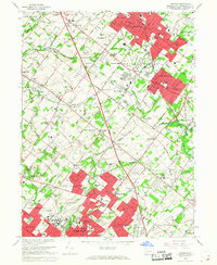
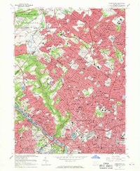
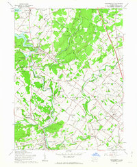 1960 Perkiomenville1963 Print · USGSNorthern Montgomery County is shown here in the early sixties as a landscape of crossroads hamlets and winding creeks. You can trace family history at Old Goshenhoppen Ch, Tylersport, and the Salford-Upper Salford Township Sch.5 unique versions available
 - 1960 Map of Telford, 1963 Print
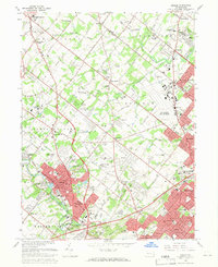
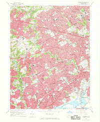
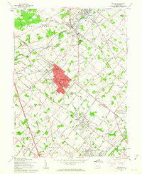 1960 Telford1963 Print · USGSThe boroughs of Souderton and Telford anchor this 1960s study of the Bucks and Montgomery county line at the height of its rail-era layout. Genealogists can trace family roots through historic sites like Schwenkfelder Ch, St Michaels Cem, and the Reading rail corridor.5 unique versions available
 - 1964 Map of Newark
 1964 Newark1964 Print · USGSGreater New Jersey and eastern Pennsylvania appear at the peak of their industrial and rail-centered development in the mid-sixties. Genealogists and historians can trace the paths of the Pennsylvania RR, identify mid-century landmarks like CAMP KILMER, or follow the Schuylkill River through READING.2 unique versions available
 - 1966 Map of Valley Forge, 1968 Print
 1966 Valley Forge1968 Print · USGSThe Main Line and Valley Forge regions are captured here in the mid-1960s as suburban growth began to surround the Revolutionary War's most famous encampment. Local historians can trace the legacy of the Schuylkill valley through Washingtons Headquarters, Great Valley Mills, and old school sites like Roberts Sch.4 unique versions available
 - 1966 Map of Collegeville, 1968 Print
 1966 Collegeville1968 Print · USGSMid-century Montgomery County comes to life as Collegeville and its neighbors expand along the Perkiomen Creek. Researchers can trace institutional history at the State Correctional Institution or find local landmarks like Ursinus College and Markleys Pond.5 unique versions available
 - 1966 Map of Norristown, 1968 Print
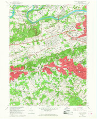
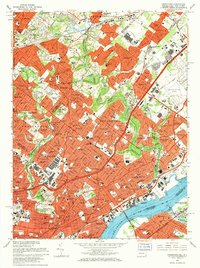
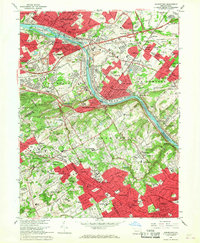 1966 Norristown1968 Print · USGSThe Schuylkill River corridor undergoes massive suburban transformation in the mid-sixties as the turnpike and expressway reshape the valley. Researchers can trace historic institutions and neighborhoods from Plymouth Meeting to Villanova University and Bryn Mawr College.3 unique versions available
 - 1966 Map of Hatboro, 1968 Print
 1966 Hatboro1968 Print · USGSMid-century Montgomery and Bucks Counties are captured here as suburban growth surrounds established towns like Hatboro and Willow Grove. Researchers can trace the sprawling U S Naval Air Development Center or locate family sites at Neshaminy Cem and Bryn Athyn Academy.3 unique versions available
 - 1966 Map of Ambler, 1968 Print
 1966 Ambler1968 Print · USGSMid-century Montgomery County is seen here during a period of rapid suburban growth and institutional expansion. Local researchers can trace the development of Ambler and Willow Grove, locating family landmarks like Hillside Cemetery and the Germantown Academy.4 unique versions available
 - 1966 Map of Wilmington, 1968 Print
 1966 Wilmington1968 Print · USGSThe Delaware Valley and Jersey Shore are seen here in the mid-1960s, documenting a landscape of dense industrial cities and emerging coastal resorts. Researchers can trace the sprawling rail networks of the Pennsylvania Railroad or locate landmarks like Fort Dix Military Reservation and Elk Neck State Park.4 unique versions available
 - 1966 Map of Lansdale, 1968 Print
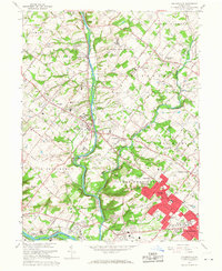
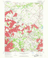
 1966 Lansdale1968 Print · USGSMontgomery County experienced significant suburban growth in the mid-sixties, as residential developments began filling the spaces between historic crossroads. Genealogists and local historians can trace the foundations of Lansdale and North Wales, or locate family sites at the St Patricks Cem and Schwenkfelder Cem.5 unique versions available
 - 1967 Map of Germantown, 1969 Print
 1967 Germantown1969 Print · USGSPhiladelphia's northern neighborhoods and the adjacent Montgomery County suburbs are shown in detail during the late sixties. Genealogists and historians can trace family locations near Germantown, locate burials in Holy Sepulchre Cemetery, or follow the rail lines through Chestnut Hill.4 unique versions available
 - 1967 Map of Lansdowne, 1969 Print
 1967 Lansdowne1969 Print · USGSDelaware County and West Philadelphia underwent significant suburban maturation during the mid-sixties. Researchers can trace family ties through numerous local landmarks like Swarthmore College, SS Peter and Paul Cemetery, and the Little Flower Institute.4 unique versions available
 - 1967 Map of Frankford, 1970 Print
 1967 Frankford1970 Print · USGSPhiladelphia's northeast reaches and the riverfront are captured here in the late sixties as urban density met heavy industry. Researchers can trace the massive Frankford Arsenal site, family plots in William Penn Cemetery, and the busy Reading Railroad corridor.5 unique versions available
 - 1967 Map of Philadelphia, 1970 Print
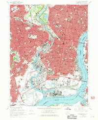 1967 Philadelphia1970 Print · USGSPhiladelphia's mid-century urban landscape is preserved here as the city adapted to new expressways and industrial shifts. Researchers can trace historic parish boundaries and landmarks like Girard College, Mt Moriah Cemetery, and the State Hospital for the Insane.6 unique versions available
End of results
Showing maps 1-15 of 15
Top cities of Montgomery County
- Abington Township historical maps
- Cheltenham Township historical maps
- Norristown historical maps
- Horsham Township historical maps
- Pottstown historical maps
- Whitemarsh Township historical maps
See more
Frequently asked questions
- What are the different types of historical maps available for Montgomery County?
- What is the oldest map of Montgomery County?
- Where can I purchase historical maps of Montgomery County for my home or office?
- Where can I download high-res historical maps of Montgomery County?
- Are there historical topographic maps available for Montgomery County?
- Is there historical aerial imagery available for Montgomery County?
- Where are historical maps of Montgomery County sourced from?