1950s Maps of Montgomery County, Pennsylvania
Explore 23 historic maps of Montgomery County from the 1950s. These maps offer a rare glimpse into what life looked like during the 1950s — showing old roads, neighborhoods, homes, and landmarks that have changed or disappeared over time.
Whether you're researching your family's past, planning a metal detecting trip, or studying how Montgomery County's landscape evolved across the 1950s, these high-resolution maps are a powerful tool for exploring the history of this region.
- Focus on a specific era: All maps on this page are from the 1950s, giving you a focused view of this time period.
- See what’s changed: Compare century-old streets, trails, and buildings to today's modern landscape using overlays and satellite layers.
- Research with precision: Use these maps for genealogy, historical research, land use analysis, or educational projects.
- View, download, or print: Maps are fully viewable online in high resolution, and can be downloaded or printed for your own records.
Start exploring Montgomery County's history through authentic maps from the 1950s. This is your window into the past.
Montgomery County, PA maps
(23)- 1950 Map of Frankford, 1953 Print
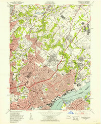 1950 Frankford1953 Print · USGSPhiladelphia in the mid-twentieth century shows a bustling industrial and institutional corridor along the Delaware River. Genealogists and historians can trace neighborhood growth through local landmarks like Montefiore Cemetery, Frankford High Sch, and the historic Frankford Arsenal.2 unique versions available
 - 1951 Map of Collegeville, 1953 Print
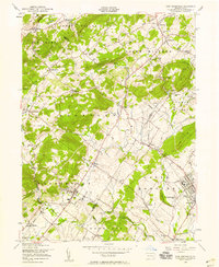
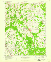
 1951 Collegeville1953 Print · USGSMontgomery County was a landscape of historic institutional grounds and creek-side villages in the early fifties. Local historians can trace the footprint of Ursinus College, locate the Eastern State Penitentiary, and find old schools like Henry R Boyer Sch.2 unique versions available
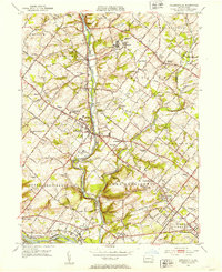
 - 1951 Map of Lansdale, 1953 Print
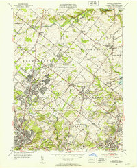
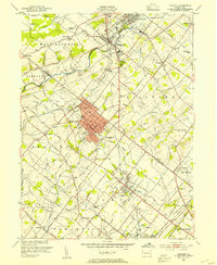
 1951 Lansdale1953 Print · USGSPost-war Montgomery County sees the transition from rural townships to growing boroughs as the rail lines hum with activity. Trace the development of Lansdale and North Wales, or find historic sites like Central Schwenkfelder Ch and the Lansdale Airport.2 unique versions available
 - 1952 Map of Valley Forge, 1953 Print
 1952 Valley Forge1953 Print · USGSThe Main Line and Valley Forge area are captured here during the early fifties suburban expansion. Genealogists and researchers can trace local landmarks like Washington Memorial Chapel, the School for Blind, and the Norbertine Monastery.3 unique versions available
 - 1952 Map of Hatboro, 1953 Print
 1952 Hatboro1953 Print · USGSGreater Hatboro and Upper Moreland are captured here in the early fifties as postwar suburban growth begins to encircle established rural hamlets. Researchers can trace the massive U S Naval Air Development Center or locate family sites at Richboro Sch and the Southampton Meetinghouse.3 unique versions available
 - 1952 Map of Ambler, 1953 Print
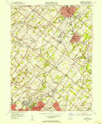
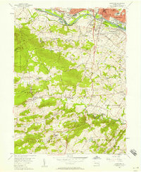
 1952 Ambler1953 Print · USGSSuburban Montgomery County was rapidly evolving in the early fifties as estates gave way to new neighborhoods. Genealogists can trace family names and local landmarks from Ambler to Spring House, including the Rose Valley Cem and the U S Naval Air Station.2 unique versions available
 - 1952 Map of Germantown, 1954 Print
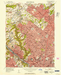 1952 Germantown1954 Print · USGSNorthwest Philadelphia and its Montgomery County suburbs are shown here in the early fifties as the region's rail-and-park network reached its peak maturity. Genealogists and local historians can locate neighborhood landmarks like Wayne Junction, Beaver College, and the many historic burial grounds including Holy Sepulchre Cemetery.2 unique versions available
 - 1952 Map of Norristown, 1954 Print
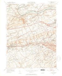
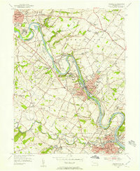
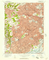
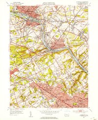 1952 Norristown1954 Print · USGSMontgomery County's river towns and Main Line colleges are captured in the early fifties during a period of rapid suburbanization. Trace the development of Villanova College and Bryn Mawr College or locate the old Patco Airport and Barbadoes Island.2 unique versions available
 - 1953 Map of Telford, 1954 Print
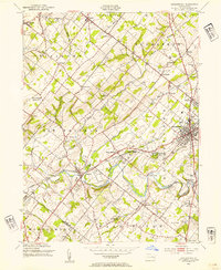
 1953 Telford1954 Print · USGSThe North Penn region comes alive in this mid-century survey, capturing the industrial heart of Souderton and Telford along the Reading railroad. Genealogists can trace family names at Jerusalem Union Ch, Franconia Sch, and the Perkasie Cem.
 - 1953 Map of Doylestown, 1954 Print
 1953 Doylestown1954 Print · USGSBucks County in the early fifties shows a landscape of growing boroughs and deep-rooted rural townships. Researchers can trace ancestral locations through numerous named schoolhouses and local institutions like the National Agricultural College and Beulah Chapel.6 unique versions available
 - 1953 Map of Perkiomenville, 1954 Print
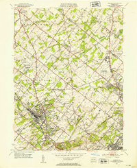
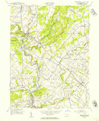 1953 Perkiomenville1954 Print · USGSCentral Montgomery County thrived as a landscape of rural villages and creekside industry in the early fifties. Genealogists and historians can trace family locations through sites like Old Goshenhoppen Ch, McLeans Station, and Harleysville.2 unique versions available
 - 1955 Map of Wilmington
 1955 Wilmington1955 Print · USGSThe Delaware Valley and Jersey Shore are seen here during the mid-fifties era of rapid suburban expansion and highway development. You can trace the path of the New Jersey Turnpike, locate the Fort Dix Military Reservation, or explore the rail networks of the Pennsylvania Railroad.
 - 1955 Map of Phoenixville, 1957 Print
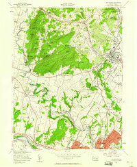
 1955 Phoenixville1957 Print · USGSPhoenixville and the surrounding townships are captured in the mid-1950s as they expanded along the winding Schuylkill River. Genealogists can trace family names through the Revolutionary Soldiers Cem, Mingo Cem, and landmarks like the Pennhurst State School.6 unique versions available
 - 1956 Map of East Greenville
 1956 East Greenville1956 Print · USGSThe Upper Perkiomen Valley thrives in the mid-fifties, centered on the boroughs of East Greenville and Pennsburg along the Reading railroad. Genealogists and local historians can locate country landmarks like New Goshenhoppen Ch, Kings Highway Sch, and the Hosensack Sta.6 unique versions available
 - 1956 Map of Newark
 1956 Newark1956 Print · USGSThe industrial heart of the Mid-Atlantic is captured here at the dawn of the highway era, tracing the dense corridors between Newark and Philadelphia. Genealogists and local historians can map the rail networks of the Reading RR or locate mid-century military life at Fort Dix Military Reservation.2 unique versions available
 - 1956 Map of Pottstown, 1957 Print
 1956 Pottstown1957 Print · USGSMid-century Pottstown and the rural townships of Chester and Montgomery counties were still deeply connected by the Reading and Pennsylvania railroads. Genealogists and local historians can trace the foundations of Nantmeal Village, the old crossroads at Titlows Corner, and historic sites like St Peters Ch.5 unique versions available
 - 1956 Map of Lansdowne, 1957 Print
 1956 Lansdowne1957 Print · USGSEastern Delaware County was reaching its mid-century peak of suburban rail-and-road density in the 1950s. Researchers can trace historic property lines near Swarthmore College, locate ancestral sites in Holy Cross Cemetery, and follow the busy Pennsylvania Railroad corridor through Lansdowne and Darby.2 unique versions available
 - 1957 Map of Wilmington
 1957 Wilmington1957 Print · USGSThe mid-Atlantic coastal plain comes alive in the mid-fifties as the New Jersey Turnpike and Garden State Parkway redefine travel. Researchers can trace the rail-to-road transition and find landmarks like Ship John Shoal Light and the Fort Dix Military Reservation.2 unique versions available
 - 1957 Map of Newark
 1957 Newark1957 Print · USGSThe industrial and military heart of the Mid-Atlantic is mapped during its post-war suburban boom. Genealogists and historians can trace the intricate rail corridors of the Reading Railroad and locate key landmarks from Princeton University to Fort Hancock.
 - 1957 Map of Sassamansville, 1958 Print
 1957 Sassamansville1958 Print · USGSNorthern Montgomery County remains a landscape of historic crossroads and farmsteads in the mid-fifties. Genealogists can trace family names at Falkner Swamp Cem or find local landmarks like Ringing Rock Park and Boyertown Airport.6 unique versions available
 - 1957 Map of Boyertown, 1958 Print
 1957 Boyertown1958 Print · USGSSoutheastern Berks County is shown here in the late fifties, where the industrial valley of the Schuylkill meets the ridges of Earl and Colebrookdale. Genealogists can locate family landmarks like Hahawas Sachem Cem, the Shanesville Chapel, and the vanished site of Woodchoppertown.6 unique versions available
 - 1957 Map of Milford Square, 1959 Print
 1957 Milford Square1959 Print · USGSUpper Bucks and Montgomery counties are captured in the late fifties as the new turnpike began to reshape rural life. Researchers can find numerous country churches and local schools, from Great Swamp Ch to the Weikel Sch and Trumbon Valley Sch.4 unique versions available
 - 1959 Map of Wilmington
 1959 Wilmington1959 Print · USGSThe Delaware Valley and Jersey Shore are seen here in the late fifties, during a period of massive suburban and highway expansion. Researchers can trace mid-century infrastructure like the N J Turnpike or locate coastal landmarks from Barnegat Bay to the Maurice River.3 unique versions available
End of results
Showing maps 1-23 of 23
Top cities of Montgomery County
- Abington Township historical maps
- Cheltenham Township historical maps
- Norristown historical maps
- Horsham Township historical maps
- Pottstown historical maps
- Whitemarsh Township historical maps
See more
Frequently asked questions
- What are the different types of historical maps available for Montgomery County?
- What is the oldest map of Montgomery County?
- Where can I purchase historical maps of Montgomery County for my home or office?
- Where can I download high-res historical maps of Montgomery County?
- Are there historical topographic maps available for Montgomery County?
- Is there historical aerial imagery available for Montgomery County?
- Where are historical maps of Montgomery County sourced from?