1940s Maps of Buffalo Township, Pennsylvania
Explore 6 historic maps of Buffalo Township from the 1940s. These maps offer a rare glimpse into what life looked like during the 1940s — showing old roads, neighborhoods, homes, and landmarks that have changed or disappeared over time.
Whether you're researching your family's past, planning a metal detecting trip, or studying how Buffalo Township's landscape evolved across the 1940s, these high-resolution maps are a powerful tool for exploring the history of this region.
- Focus on a specific era: All maps on this page are from the 1940s, giving you a focused view of this time period.
- See what’s changed: Compare century-old streets, trails, and buildings to today's modern landscape using overlays and satellite layers.
- Research with precision: Use these maps for genealogy, historical research, land use analysis, or educational projects.
- View, download, or print: Maps are fully viewable online in high resolution, and can be downloaded or printed for your own records.
Start exploring Buffalo Township's history through authentic maps from the 1940s. This is your window into the past.
Buffalo Township, PA maps
(6)- 1943 Map of Millerstown
 1943 Millerstown1943 Print · USGSMid-Pennsylvania ridge-and-valley life is captured here during the 1940s as the Juniata River corridor serves the Pennsylvania Railroad. Genealogists and historians can locate numerous rural landmarks like Beers Foundry, Arbogast Church, and the Hiester Valley School.
 - 1943 Map of Millersburg
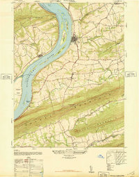
 1943 Millersburg1943 Print · USGSDauphin and Northumberland counties appear here during the mid-1940s, defined by the river-and-rail economy along the Susquehanna River. Researchers can trace the heritage of small valley towns through landmarks like St Johns Church, Morning Glory School, and the Limestone Quarries.
 - 1943 Map of Harrisburg
 1943 Harrisburg1943 Print · USGSThe Pennsylvania capital and its surrounding Susquehanna riverfront are seen here during the war years. Researchers can trace the extensive rail networks and find local landmarks like Fort Hunter, Good Hope Mills, and Wenrichs Ch.3 unique versions available
 - 1943 Map of New Bloomfield
 1943 New Bloomfield1943 Print · USGSPerry County's ridge-and-valley landscape is captured here during the Second World War as the rail-and-river corridor remained vital to the region. Genealogists can locate family landmarks like Hustons Mill, Mecks Corner, and the old Wila P O post office.
 - 1947 Map of Halifax
 1947 Halifax1947 Print · USGSThe Susquehanna River valley emerges in the post-war era as a landscape of mountain ridges and fertile river islands. Genealogists can locate family landmarks like Jacobs Church, the Shamokin School, and old riverside settlements from New Buffalo to Speeceville.3 unique versions available
 - 1947 Map of Millersburg
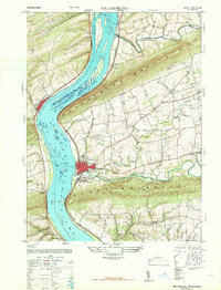 1947 Millersburg1947 Print · USGSThe Susquehanna River valley and the ridges of Central Pennsylvania are captured here just after the war. Local historians can trace family sites like Killinger School, navigate the Millersburg Ferry, and locate old river crossings such as Montgomery Ferry.2 unique versions available
End of results
Showing maps 1-6 of 6
Top cities near Buffalo Township
- Harrisburg historical maps
- Colonial Park historical maps
- Middlesex Township historical maps
- Linglestown historical maps
- Enola historical maps
- Paxtonia historical maps
See more
Top neighborhoods of Buffalo Township
Frequently asked questions
- What are the different types of historical maps available for Buffalo Township?
- What is the oldest map of Buffalo Township?
- Where can I purchase historical maps of Buffalo Township for my home or office?
- Where can I download high-res historical maps of Buffalo Township?
- Are there historical topographic maps available for Buffalo Township?
- Is there historical aerial imagery available for Buffalo Township?
- Where are historical maps of Buffalo Township sourced from?