Old Maps of Short Run, Abbott Township for Hiking & Exploration
Hike through history with 15 historic maps of Short Run. Explore old trails, ghost towns, and forgotten backroads — perfect for outdoor adventurers and local explorers.
- Rediscover forgotten places: Map out old mining camps, roads, and footpaths that no longer exist on modern maps.
- Layer with modern tools: Combine with LiDAR or satellite views to plan hikes through historical terrain.
- Made for exploration: Popular among hikers, overlanders, and local history lovers.
Use these maps to find adventure and explore the hidden past of Short Run.
Short Run, Abbott Township maps
(15)- 1947 Map of Conrad, 1952 Print
 1947 Conrad1952 Print · USGSPotter County’s timbered ridges and deep hollows are captured here just after the war, showing a rural landscape before modern development. Researchers can locate family cemeteries like Angell Cem and Reed Cem, or trace the old Jersey Shore Turnpike.4 unique versions available
 - 1947 Map of Short Run, 1956 Print
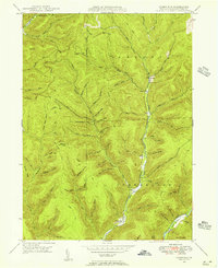 1947 Short Run1956 Print · USGSPotter County’s timbered ridges and deep hollows are documented here just after the war, showing the remote township corners and mountain trails. Trace family-named landmarks like Knickerbocker Hol and Yochum Run or find the early paths at Short Run.2 unique versions available
 - 1949 Map of Short Run
 1949 Short Run1949 Print · USGSPotter County’s high plateaus and steep hollows are caught in fine detail during the late 1940s as forest roads began replacing old upland paths. Researchers can trace historic routes like the Splash Dam Trail and locate family-named landmarks such as Knickerbocker Hol and Bunnell Ridge.
 - 1954 Map of Williamsport
 1954 Williamsport1954 Print · USGSNorth-central Pennsylvania in the mid-fifties is defined by the winding West Branch Susquehanna River and its industrial valley. Local historians can trace the massive Susquehanna Ordnance Depot and the extensive rail networks of the Pennsylvania Railroad.
 - 1960 Map of Williamsport
 1960 Williamsport1960 Print · USGSNorth-central Pennsylvania in the mid-twentieth century was a vital corridor of rail and river industry stretching from the New York line to the coal regions. Genealogists can trace the rail networks of the Pennsylvania RR and Lehigh Valley RR connecting towns like Williamsport, Towanda, and Lock Haven.
 - 1962 Map of Williamsport, 1966 Print
 1962 Williamsport1966 Print · USGSNorth-central Pennsylvania was a landscape of industrial river hubs and vast state woodlands in the early sixties. Researchers can trace the path of the Pennsylvania Railroad through Williamsport and explore the remote reaches of Bucktail State Park.5 unique versions available
 - 1965 Map of Williamsport
 1965 Williamsport1965 Print · USGSNorth-central Pennsylvania in the mid-1960s is defined by the industrial river towns and vast timberlands of the Allegheny Plateau. Researchers can trace historic rail lines like the Erie Lackawanna and Reading as they thread through Williamsport, Lock Haven, and Jersey Shore.
 - 1966 Map of Williamsport
 1966 Williamsport1966 Print · USGSThe Susquehanna Valley was a hub of transit and industry in the mid-seventies, where the river's West Branch connected major college towns and timberlands. Researchers can trace historical rail lines like the Reading or locate regional landmarks from Jersey Shore to Ricketts Glen State Park.
 - 1971 Map of Short Run, 1984 Print
 1971 Short Run1984 Print · USGSPotter County’s high Allegheny Plateau is captured here during the early 1970s, showcasing the isolated settlements and logging-era remnants of North Central Pennsylvania. Genealogists and hikers can trace old routes along the Splash Dam Trail or locate remote points like Elk Lick Knob and the small outpost at Abbott.
 - 1981 Map of Wellsboro, 1982 Print
 1981 Wellsboro1982 Print · USGSNorthern Pennsylvania in the early eighties shows a landscape of deep river gorges and vast state forests. Trace the rail lines of Conrail and explore old settlements from Coudersport to the Pine Creek Gorge.
 - 2010 Map of Short Run, 2010 Print
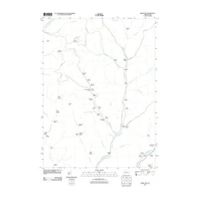 2010 Short Run2010 Print · USGSCovers Short Run, including Abbott Township, Wharton Township, and other nearby areas
 - 2013 Map of Short Run, 2013 Print
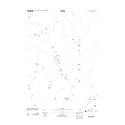 2013 Short Run2013 Print · USGSCovers Short Run, including Abbott Township, Wharton Township, and other nearby areas
 - 2016 Map of Short Run, 2016 Print
 2016 Short Run2016 Print · USGSCovers Short Run, including Abbott Township, Wharton Township, and other nearby areas
 - 2019 Map of Short Run, 2019 Print
 2019 Short Run2019 Print · USGSCovers Short Run, including Abbott Township, Wharton Township, and other nearby areas
 - 2023 Map of Short Run, 2023 Print
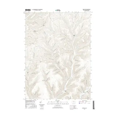
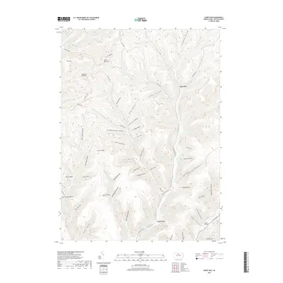
 2023 Short Run2023 Print · USGSPotter County's deep forest interior is shown here in the 2020s, featuring the remote junctions of the Susquehannock Trail System Tri. Trace the narrow valley roads to Gravel Lick, Short Run, and the high ridges of Bunnell Ridge and Elk Lick Knob.
End of results
Showing maps 1-15 of 15
Top cities near Short Run
- Galeton historical maps
- Sweden Township historical maps
- Clymer Township historical maps
- Gaines Township historical maps
- Leidy Township historical maps
- Abbott Township historical maps
See more
Frequently asked questions
- What are the different types of historical maps available for Short Run?
- What is the oldest map of Short Run?
- Where can I purchase historical maps of Short Run for my home or office?
- Where can I download high-res historical maps of Short Run?
- Are there historical topographic maps available for Short Run?
- Is there historical aerial imagery available for Short Run?
- Where are historical maps of Short Run sourced from?