Old Maps of Walker Township, Pennsylvania for Metal Detecting
Plan your next treasure hunt with 59 historic maps of Walker Township. Find old homesites, ghost towns, trails, and gathering spots that may be lost to time — perfect for identifying promising metal detecting locations.
- Locate forgotten sites: Uncover places like long-lost settlements, abandoned rail lines, or gathering spots.
- Plan better hunts: Use map overlays combined with LiDAR or satellite views to narrow in on historically rich areas.
- Made for detectorists: Thousands of hobbyists use these maps to discover relics, coins, and hidden history.
Use these historic maps to boost your research and find new opportunities beneath the surface of Walker Township.
Walker Township, PA maps
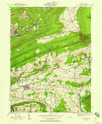
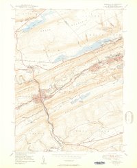
(59)- 1889 Map of Hazleton, 1956 Print
 1889 Hazleton1956 Print · USGSThe Pennsylvania coal fields are seen at their industrial height in the late 1880s, revealing a landscape defined by anthracite and iron rails. Genealogists and historians can trace the early footprints of Hazleton, the company town of Eckley, and the rail-heavy corridors of Lansford and Tamaqua.
 - 1889 Map of Pottsville, 1964 Print
 1889 Pottsville1964 Print · USGSAnthracite coal country and the complex rail networks of the late nineteenth century dominate this survey of the Schuylkill River valley. Genealogists and industrial historians can trace the early footprints of Pottsville, Schuylkill Haven, and the numerous rail branches serving New Philadelphia and Port Carbon.
 - 1891 Map of Hazleton
 1891 Hazleton1891 Print · USGSThe anthracite coal region comes alive in the late nineteenth century, showing a landscape defined by ridges and rail lines. Genealogists and historians can trace the early footprints of Hazleton, the gravity-rail heritage at Summit Hill, and the bustling yards of Lansford or Tamaqua.
 - 1891 Map of Pottsville
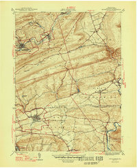
 1891 Pottsville1891 Print · USGSSchuylkill County enters its industrial height in the 1890s, when anthracite coal and iron rails reshaped the mountains. Trace the dense rail networks of the Philadelphia and Reading Railroad connecting Pottsville, St. Clair, and Schuylkill Haven.10 unique versions available
 - 1892 Map of Mahanoy
 1892 Mahanoy1892 Print · USGSSchuylkill and Luzerne counties are captured here at a peak of industrial development during the 1890s coal era. Researchers can trace the massive rail networks serving Shenandoah, Mahanoy City, and lost junctions like Silver Brook Junction.
 - 1893 Map of Hazleton
 1893 Hazleton1893 Print · USGSThe anthracite coal region of Northeastern Pennsylvania is captured here in the late nineteenth century, during its industrial peak. Genealogists and historians can trace the early rail networks and company patches like Lansford, Summit Hill, and the coal-rich village of Eckley.8 unique versions available
 - 1893 Map of Mahanoy, 1898 Print
 1893 Mahanoy1898 Print · USGSSchuylkill and Luzerne counties are shown at the height of the coal era, revealing a landscape etched by mining and rail commerce. Genealogists and industrial historians can trace the specific neighborhoods of Shenandoah, Mahanoy City, and the railway junctions at Tamanend and Delano.7 unique versions available
 - 1909 Map of Hamburg, 1957 Print
 1909 Hamburg1957 Print · USGSSchuylkill and Berks counties are captured here during the height of the steam era, showing the intricate relationship between the mountain gaps and the rail lines. Genealogists and researchers can trace old postal routes through Wessnersville Stony Run P O, locate the historic Five Locks, and identify family farms near Crystal Cave.
 - 1911 Map of Hamburg
 1911 Hamburg1911 Print · USGSBerks and Schuylkill counties are captured here at a peak of rail-driven rural life just before the Great War. Researchers can trace family roots through specific locales like New Ringgold, Dorset Sta, and the historic Five Locks along the Schuylkill River.5 unique versions available
 - 1944 Map of Orwigsburg, 1958 Print
 1944 Orwigsburg1958 Print · USGSSchuylkill County during the mid-forties reveals a landscape split between coal-valley industry and fertile lowland farming. Genealogists can locate family-named landmarks like Breiner Sch or trace the early postal routes through New Philadelphia Silver Creek P O.6 unique versions available
 - 1944 Map of Newark, 1971 Print
 1944 Newark1971 Print · USGSThe industrial corridor from Philadelphia to New York was in a period of massive transition during the mid-forties. Genealogists and researchers can trace the rail lines of the Lehigh Valley RR, locate military installations like Picatinny Arsenal, and explore the early sprawl near Levittown.5 unique versions available
 - 1947 Map of Orwigsburg
 1947 Orwigsburg1947 Print · USGSSchuylkill County in the years following the war shows a landscape shaped by coal-country railroads and river valleys. Researchers can trace the Reading rail lines connecting New Philadelphia Silver Creek P O, Orwigsburg, and local landmarks like Kunkles Dam.2 unique versions available
 - 1947 Map of Tamaqua, 1964 Print
 1947 Tamaqua1964 Print · USGSThe Panther Valley coal region is captured here at a mid-century peak of industrial activity. Researchers can trace the extensive rail networks at Arlington Yards or locate local landmarks like Odd Fellows Cem and Owl Creek Sch.5 unique versions available
 - 1949 Map of Newark
 1949 Newark1949 Print · USGSThe industrial corridor between Philadelphia and New York comes alive in this post-war survey. Genealogists and historians can trace the massive rail networks of the Reading Railroad and locate major installations like Fort Dix or Picatinny Arsenal.2 unique versions available
 - 1949 Map of Delano
 1949 Delano1949 Print · USGSSchuylkill County at the peak of its rail-and-coal era shows a landscape defined by steep ridges and vital transit junctions. Genealogists can trace family roots through St Nicholas Cem, rural schoolhouses like Lakeside Sch, and coal settlements such as Grier City and Park Crest.2 unique versions available
 - 1950 Map of Tamaqua
 1950 Tamaqua1950 Print · USGSThe anthracite coal region of Schuylkill and Carbon counties comes into sharp focus during the mid-century peak of industrial activity. Trace the dense rail networks of the Reading Co through Tamaqua and locate ancestral landmarks like the Odd Fellows Cem or Owl Creek Sch.2 unique versions available
 - 1950 Map of Harrisburg, 1952 Print
 1950 Harrisburg1952 Print · USGSMid-century Central Pennsylvania comes alive through its dense rail networks and river valley settlements during the post-war industrial era. Genealogists and historians can trace family roots through hubs like Harrisburg, locate Carlisle Barracks, or follow the Pennsylvania RR through the Lebanon Valley.
 - 1954 Map of Delano, 1956 Print
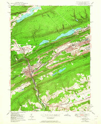
 1954 Delano1956 Print · USGSSchuylkill County at the height of its rail-and-mine era reveals an intricate landscape of industrial junctions and valley settlements. Genealogists and historians can trace the footprint of community life at the St Peters Ch, Primrose Mine, and the Lakeside Sch.5 unique versions available
 - 1955 Map of Mahanoy, 1960 Print
 1955 Mahanoy1960 Print · USGSThe anthracite coalfields of Schuylkill County are shown in full industrial operation during the mid-1950s. Researchers can locate specific colliery sites and landmarks like Harwood, the Mahanoy Tunnel, and the lone Peddlars Grave.
 - 1956 Map of Newark
 1956 Newark1956 Print · USGSThe industrial heart of the Mid-Atlantic is captured here at the dawn of the highway era, tracing the dense corridors between Newark and Philadelphia. Genealogists and local historians can map the rail networks of the Reading RR or locate mid-century military life at Fort Dix Military Reservation.2 unique versions available
 - 1956 Map of New Ringgold, 1957 Print
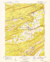
 1956 New Ringgold1957 Print · USGSSchuylkill and Berks counties are captured here in the mid-fifties, showing a landscape of ridge-top trails and valley railroads. Genealogists and historians can trace family roots through the West Penn Ch Cem, numerous rural schoolhouses like Dorset Sch, and the quiet borough of New Ringgold.6 unique versions available
 - 1956 Map of Hamburg, 1960 Print
 1956 Hamburg1960 Print · USGSPennsylvania's ridge-and-valley country comes to life in the mid-fifties, from the Schuylkill River to the Lehigh border. Genealogists and hikers can trace the Appalachian Trail over Blue Mountain or locate family roots near New Bethel Ch and Crystal Cave.2 unique versions available
 - 1957 Map of Harrisburg
 1957 Harrisburg1957 Print · USGSMid-century Central Pennsylvania comes into focus as a bustling network of rail, river, and mountain ridges. Genealogists and historians can trace the development of the State Capitol and surrounding hubs like Middletown, Columbia, and Pottsville.7 unique versions available
 - 1957 Map of Newark
 1957 Newark1957 Print · USGSThe industrial and military heart of the Mid-Atlantic is mapped during its post-war suburban boom. Genealogists and historians can trace the intricate rail corridors of the Reading Railroad and locate key landmarks from Princeton University to Fort Hancock.
 - 1960 Map of Newark
 1960 Newark1960 Print · USGSThe industrial heart of the Mid-Atlantic is shown at mid-century, stretching from the dense urban centers of Newark and Philadelphia to the Blue Mountain ridges. Researchers can trace historic rail lines, coastal defenses at Fort Hancock, and the riverfront growth of Trenton and Easton.3 unique versions available
Showing maps 1-25 of 59
Top cities near Walker Township
- Hazleton historical maps
- Pottsville historical maps
- Maxatawny Township historical maps
- Tamaqua historical maps
- Shenandoah historical maps
- Schuylkill Haven historical maps
See more
Top neighborhoods of Walker Township
- Zehners historical maps
- Lewistown historical maps
- New England historical maps
- Reynolds historical maps
- Webster historical maps
Frequently asked questions
- What are the different types of historical maps available for Walker Township?
- What is the oldest map of Walker Township?
- Where can I purchase historical maps of Walker Township for my home or office?
- Where can I download high-res historical maps of Walker Township?
- Are there historical topographic maps available for Walker Township?
- Is there historical aerial imagery available for Walker Township?
- Where are historical maps of Walker Township sourced from?