1970s Maps of Northampton Township, Pennsylvania
Explore 4 historic maps of Northampton Township from the 1970s. These maps offer a rare glimpse into what life looked like during the 1970s — showing old roads, neighborhoods, homes, and landmarks that have changed or disappeared over time.
Whether you're researching your family's past, planning a metal detecting trip, or studying how Northampton Township's landscape evolved across the 1970s, these high-resolution maps are a powerful tool for exploring the history of this region.
- Focus on a specific era: All maps on this page are from the 1970s, giving you a focused view of this time period.
- See what’s changed: Compare century-old streets, trails, and buildings to today's modern landscape using overlays and satellite layers.
- Research with precision: Use these maps for genealogy, historical research, land use analysis, or educational projects.
- View, download, or print: Maps are fully viewable online in high resolution, and can be downloaded or printed for your own records.
Start exploring Northampton Township's history through authentic maps from the 1970s. This is your window into the past.
Northampton Township, PA maps
(4)- 1977 Map of Berlin, 1978 Print
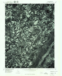 1977 Berlin1978 Print · USGSSomerset County agriculture and industry are captured in high detail in the late seventies. Genealogists and local researchers can trace family lands near Berlin and identify the specific layouts of small settlements like Macdonaldton and Shaft.
 - 1977 Map of New Baltimore, 1979 Print
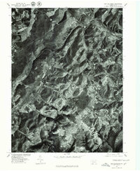 1977 New Baltimore1979 Print · USGSThe Somerset County countryside comes into focus in the late seventies, showing the intricate patchwork of farms and timber along the Raystown Branch Juniata River. Trace the rural layout of New Baltimore, Mt Zion, and the high terrain of Dividing Ridge.
 - 1977 Map of Wittenburg, 1979 Print
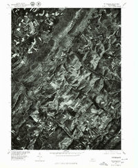 1977 Wittenburg1979 Print · USGSSomerset County agriculture and topography are captured during the late seventies, showing the intricate patterns of contour farming across the ridges. Genealogists and local historians can trace the rural layouts of Wittenberg and Philson along the banks of Wills Creek.
 - 1977 Map of Fairhope, 1979 Print
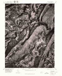 1977 Fairhope1979 Print · USGSSomerset County in the late seventies is seen through high-altitude aerial imagery, capturing the steep ridges and narrow valleys of the Allegheny Front. Local historians can trace small rural clusters like Fairhope, Pinnells Mills, and Glencoe.
End of results
Showing maps 1-4 of 4
Top cities near Northampton Township
- Cumberland historical maps
- Frostburg historical maps
- Somerset historical maps
- La Vale historical maps
- Meyersdale historical maps
- Napier Township historical maps
See more
Top neighborhoods of Northampton Township
- Foley historical maps
- Glencoe historical maps
- Johnsburg historical maps
- Philson historical maps
- Mance historical maps
Frequently asked questions
- What are the different types of historical maps available for Northampton Township?
- What is the oldest map of Northampton Township?
- Where can I purchase historical maps of Northampton Township for my home or office?
- Where can I download high-res historical maps of Northampton Township?
- Are there historical topographic maps available for Northampton Township?
- Is there historical aerial imagery available for Northampton Township?
- Where are historical maps of Northampton Township sourced from?