1990s Maps of Susquehanna County, Pennsylvania
Explore 14 historic maps of Susquehanna County from the 1990s. These maps offer a rare glimpse into what life looked like during the 1990s — showing old roads, neighborhoods, homes, and landmarks that have changed or disappeared over time.
Whether you're researching your family's past, planning a metal detecting trip, or studying how Susquehanna County's landscape evolved across the 1990s, these high-resolution maps are a powerful tool for exploring the history of this region.
- Focus on a specific era: All maps on this page are from the 1990s, giving you a focused view of this time period.
- See what’s changed: Compare century-old streets, trails, and buildings to today's modern landscape using overlays and satellite layers.
- Research with precision: Use these maps for genealogy, historical research, land use analysis, or educational projects.
- View, download, or print: Maps are fully viewable online in high resolution, and can be downloaded or printed for your own records.
Start exploring Susquehanna County's history through authentic maps from the 1990s. This is your window into the past.
Susquehanna County, PA maps
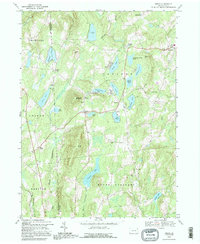
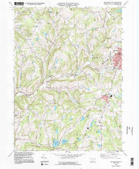
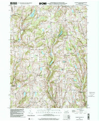
(14)- 1992 Map of Harford, 1995 Print
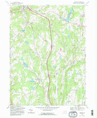 1992 Harford1995 Print · USGSNortheastern Pennsylvania’s crossroads and farm country are captured here during the 1990s as the region balanced its rural character with modern transit. Genealogists can trace family landmarks and historic hamlets from Sweet Chapel to Kentuck Corners and Steinbachs Corners.2 unique versions available
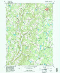
 - 1992 Map of Great Bend, 1995 Print
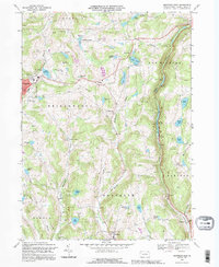
 1992 Great Bend1995 Print · USGSSusquehanna County at the New York border shows a landscape of river loops and ridges in the early 1990s. Local researchers can locate family sites near Brushville, Hickory Grove, and Highland Cem or trace the Conrail line through Hallstead.
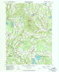
 - 1992 Map of Laurel Lake, 1995 Print
 1992 Laurel Lake1995 Print · USGSSusquehanna County highland life at the New York border is preserved here, showing a landscape defined by glacial waters and rural industry. Trace family roots at St Augustine Ch or Brackney Cem, and locate old landmarks like Fisk Mill and Silver Lake.
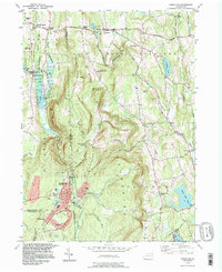
 - 1992 Map of Franklin Forks, 1995 Print
 1992 Franklin Forks1995 Print · USGSSusquehanna County near the New York border shows a landscape of small farming hamlets and active stone extraction in the mid-1990s. Genealogists and local researchers can locate Franklin Forks, Mountain Valley Cem, and the rural crossroads of Upsonville.
 - 1992 Map of Orson, 1995 Print
 1992 Orson1995 Print · USGSHigh in the lake country of Wayne County in the early nineties, this survey captures the headwaters of the Lackawanna. Genealogists can find family landmarks like Orson Cem, Hines Corners, and Orson Ch along the winding mountain roads.
 - 1992 Map of Montrose East, 1995 Print
 1992 Montrose East1995 Print · USGSSusquehanna County in the early nineties shows a landscape of clustered hill-country settlements and upland glacial lakes. Trace the paths of the Old Railroad Grade and find historic landmarks like Newton Hill Cem and East Bridgewater Ch.
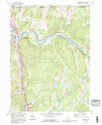
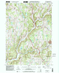
 - 1994 Map of Susquehanna, 1995 Print
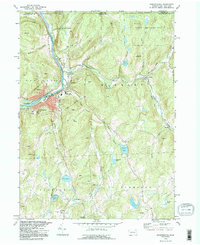 1994 Susquehanna1995 Print · USGSSusquehanna and Oakland sit at a major river bend during the late twentieth century, showing a landscape shaped by stone quarries and rail history. Trace local genealogy and industry through St Johns Cem, the Old Railroad Grade, and Lanesboro.
 - 1994 Map of Hop Bottom, 1995 Print
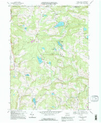
 1994 Hop Bottom1995 Print · USGSSusquehanna County in the mid-1990s reveals a landscape of high ridges and glacial ponds centered on the borough of Hop Bottom. Genealogists and researchers can locate family landmarks like Squiers Cem, Union Ch, and the old settlement at Deckertown.
 - 1994 Map of Montrose West, 1995 Print
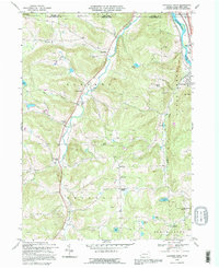
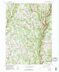
 1994 Montrose West1995 Print · USGSSusquehanna County’s ridge-and-valley landscape was well-established by the mid-1990s, centering on the administrative hub of Montrose. Researchers can trace old family sites and rural infrastructure from Bumps Corners and Snows Mill to Zaverton Airport and North Hill Cem.2 unique versions available
 - 1994 Map of Thompson, 1995 Print
 1994 Thompson1995 Print · USGSSusquehanna County in the mid-1990s retains its rural character, defined by upland ridges and historic turnpikes. Trace local family history at Jackson Cem and St Martins Ch, or follow the waters of Tunkhannock Creek through the hills.
 - 1994 Map of Clifford, 1995 Print
 1994 Clifford1995 Print · USGSIn the mid-1990s, this area of Susquehanna County maintained its quiet character among the high peaks of the Endless Mountains. Genealogists and local historians can trace family ties at Dundaff Cem, St Johns Ch, and the long-established settlement of Clifford.
 - 1994 Map of Forest City, 1996 Print
 1994 Forest City1996 Print · USGSNortheastern Pennsylvania’s high country near the turn of the millennium shows a landscape defined by the Lackawanna River and its upland reservoirs. Trace the historic Old Newburgh Turnpike and locate old family cemeteries like Maple Grove Cem and Sherwood Cem.
 - 1999 Map of Auburn Center, 2001 Print
 1999 Auburn Center2001 Print · USGSSusquehanna County remains a landscape of high ridges and rural crossroads at the close of the twentieth century. Genealogists can trace family landmarks and burial sites like Boles Cem, Jersey Hill Ch, and the settlement at Auburn Center.
 - 1999 Map of Lenoxville, 2001 Print
 1999 Lenoxville2001 Print · USGSSusquehanna County at the close of the twentieth century remains a landscape of high ridges and deep creek valleys. Genealogists and local historians can trace legacy sites like Maplewood Cem, Wright Sch, and the riverside settlement of Lenoxville.2 unique versions available
End of results
Showing maps 1-14 of 14
Top cities of Susquehanna County
- Bridgewater Township historical maps
- Clifford Township historical maps
- Lenox Township historical maps
- Springville Township historical maps
- Silver Lake Township historical maps
- Harford Township historical maps
See more
Frequently asked questions
- What are the different types of historical maps available for Susquehanna County?
- What is the oldest map of Susquehanna County?
- Where can I purchase historical maps of Susquehanna County for my home or office?
- Where can I download high-res historical maps of Susquehanna County?
- Are there historical topographic maps available for Susquehanna County?
- Is there historical aerial imagery available for Susquehanna County?
- Where are historical maps of Susquehanna County sourced from?